
Boydston


Dun (Period Unassigned)
Site Name Boydston
Classification Dun (Period Unassigned)
Canmore ID 41112
Site Number NS24SW 2
NGR NS 2195 4485
Datum OSGB36 - NGR
Permalink http://canmore.org.uk/site/41112


- Council North Ayrshire
- Parish West Kilbride
- Former Region Strathclyde
- Former District Cunninghame
- Former County Ayrshire
NS24SW 2 2195 4484.
(NS 2195 4484) Dun (NR)
OS 6" map (1971)
Fort, Boydston.
J Smith 1895
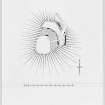
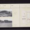
This sub-oval fort measures 18 by 14m and is situated on a promontory with steep natural slopes on th E, S and W with a ditch some 40m wide and 3m below the fort, crossing the promontory on the N. Round the N side of the fort are the remains of a stone wall, 2m wide and 1.6m high. It occupies a commanding position with an extensive view of the coast. Visited by OS (DS) 14 September 1956
A dun (RCAHMS plan, 1953), generally as described above. Excavation has revealed a short stretch of the inner wall-face. There is evidence that the dun has had an additional defence on the NE side, about 6.0m from the main wall.
Resurveyed at 1:2500.
Visited by OS (JTT) 21 October 1964
No change; a dun generally as described.
Visited by OS (JRL) 13 October 1982
Field Visit (26 May 1953)
This site was included within the RCAHMS Marginal Land Survey (1950-1962), an unpublished rescue project. Site descriptions, organised by county, are available to view online - see the searchable PDF in 'Digital Items'. These vary from short notes, to lengthy and full descriptions. Contemporary plane-table surveys and inked drawings, where available, can be viewed online in most cases - see 'Digital Images'. The original typecripts, notebooks and drawings can also be viewed in the RCAHMS search room.
Information from RCAHMS (GFG) 19 July 2013.

