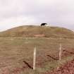
Knockrivoch Mount
Barrow (Prehistoric)(Possible)
Site Name Knockrivoch Mount
Classification Barrow (Prehistoric)(Possible)
Alternative Name(s) Motte
Canmore ID 40971
Site Number NS24NE 13
NGR NS 2534 4510
Datum OSGB36 - NGR
Permalink http://canmore.org.uk/site/40971
- Council North Ayrshire
- Parish Ardrossan
- Former Region Strathclyde
- Former District Cunninghame
- Former County Ayrshire
NS24NE 13 2534 4510.
(NS 2534 4510) Knockrivoch Mount (NAT) Motte (NR)
OS 6" map (1970)
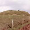
Knochrivoch Mount, a motte (information from K A Steer, RCAHMS, letter, 16 April 1954) is wholly composed of earth; in 1856 it stood 12ft high, its level top measuring about 53ft by 30ft. Smith notes that a small part of it has been removed.
Name Book 1856; J Smith 1895
Knockrivoch Mount is a motte, situated on the summit of a low ridge with a commanding view in all directions. It measures overall 30.0m E-W by 21.0m transversely, its top measuring 9.5m by 6.0m. There is the suggestion of a berm, some 5.0m wide, round the base of the mound, but no definite indication of a ditch. Its earthen construction is exposed where the grass has been removed. There is no trace of a bailey. (RCAHMS Marginal Lands TS)
Revised at 25".
Visited by OS (DS) 14 September 1956 and (WDJ) 24 November 1965
Failing any historical evidence to the contrary, the possibility of this totally artifical and remotely placed mound being a motte is untenable. Generally as described, its oval shape (approximately 30 by 24m and 3.3m high) would seem to be the result of truncation on its N side (note Smith), and it was possibly once circular and some 30m in diameter. The slight berm, most evident on the S and W, is sigificant and could represent either a general levelling of the area prior to construction or a scrape zone for the mound material.
This may be a tumulus; its form and location bears comparison with Court Hill, Dalry (NS24NE 3).
Visited by OS (JRL) 27 October 1982
Field Visit (2 June 1952)
This site was included within the RCAHMS Marginal Land Survey (1950-1962), an unpublished rescue project. Site descriptions, organised by county, are available to view online - see the searchable PDF in 'Digital Items'. These vary from short notes, to lengthy and full descriptions. Contemporary plane-table surveys and inked drawings, where available, can be viewed online in most cases - see 'Digital Images'. The original typecripts, notebooks and drawings can also be viewed in the RCAHMS search room.
Information from RCAHMS (GFG) 19 July 2013.


