Kildalvan, Burial Ground And Chapel
Burial Ground (Medieval), Chapel (Medieval)(Possible), Holy Well (Period Unassigned)(Possible), Lime Kiln (Post Medieval)
Site Name Kildalvan, Burial Ground And Chapel
Classification Burial Ground (Medieval), Chapel (Medieval)(Possible), Holy Well (Period Unassigned)(Possible), Lime Kiln (Post Medieval)
Canmore ID 40514
Site Number NS08NW 8
NGR NS 01847 89204
Datum OSGB36 - NGR
Permalink http://canmore.org.uk/site/40514
- Council Argyll And Bute
- Parish Kilmodan
- Former Region Strathclyde
- Former District Argyll And Bute
- Former County Argyll
NS08NW 8 01847 89204.
(NS 0185 8920) Burial Ground (NR) (Site of)
OS 6" map (1900)
This spot is well known as an old place of burial, said to have been used by the people in the neighbourhood. There is no tradition of a church having existed near the spot.
Name Book 1870
The remains of an oval burial ground measuring 40m NNE- SSW by 25m bounded on the N by a burn, on the W by an old field dyke, and on the E by a probably original stone bank.
Within the burial ground are the slight remains of a rectangular building measuring c.6.5m ESE-WNW by c.3.0m between turf-covered stony walls 3.0m wide and 0.3m high which is possibly the remains of a chapel.
Surveyed at 1:10,000.
Visited by OS (DWR) 21 November 1972
INVENTORY OF GRAVEYARD AND CEMETERY SITES IN SCOTLAND REFERENCE:
Address: Kildalven, Burial Ground
Postcode: PA22 3AB
Status: No longer extant
Size: N/a
TOIDs:
Number of gravestones: Not known
Earliest gravestone: Not known
Most recent gravestone: Now known
Description: Burial ground possible associated with a chapel, no longer extant
Data Sources: OS MasterMap checked 21 September 2005
Field Visit (March 1987)
These remains are situated on the NW hillside of Glendaruel, at a height of about 110m above the valley-bottom and 250m NE of Kildalvan township (No. 223). The name of the settlement is recorded, in 1491 and later, with little variation from its present form, and the dedication is uncertain (en.1).
The site is a roughly oval platform about 35m from NE to SW, bounded on the NE by the gorge of a stream, on the W by ground some 3m higher whose scarp is surmounted by a later turf dyke, and on the SE by a natural slope of some 10m to a lower terrace. In the NE part there are the turf-covered footings of a building about 6.5m from NW to SE by 4.5m internally, which may have been a chapel. A short length of stone wall extending SE from its SE angle is of uncertain purpose, and there are no identifiable burials, although in1870 the site was 'well known as an old place of burial’ (en.2).
At the NE angle of the platform there is a turf-covered stony mound with a central hollow about 2m in diameter and 1m deep, with breaks in the walls on two sides. This was probably a simple lime kiln, of a type found elsewhere in Argyll (en.3); there are numerous outcrops of limestone on the adjacent hillside, and this location may have been chosen tore-use building-material from the chapel and enclosure, as well as for its exposed position and proximity to the stream.
Local tradition refers to a nearby healing well known as 'Tobar na Suil' ('Well of the eyes') (en.4), which may have been a pool in the stream, but no evidence of artificial construction has been identified.
RCAHMS 1992, visited March 1987
Measured Survey (1987)
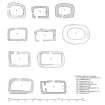
RCAHMS surveyed Kildalvan chapel and burial-ground in 1987 with plane-table and alidade producing a site plan at a scale of 1:400. The plan was redrawn in ink and published at a scale of 1:1000 (RCAHMS 1992, 104). The plan was also included in an illustration of comparative plans of early chapels published at a scale of 1:250 (RCAHMS 1992, 6F).


