
Pricing Change
New pricing for orders of material from this site will come into place shortly. Charges for supply of digital images, digitisation on demand, prints and licensing will be altered.
Bute, Muclich Hill


Shieling Hut(S) (Post Medieval), Shieling Mound(S) (Post Medieval)
Site Name Bute, Muclich Hill
Classification Shieling Hut(S) (Post Medieval), Shieling Mound(S) (Post Medieval)
Canmore ID 40490
Site Number NS07SW 24
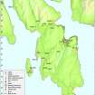
NGR NS 00931 72759
Datum OSGB36 - NGR
Permalink http://canmore.org.uk/site/40490


- Council Argyll And Bute
- Parish North Bute
- Former Region Strathclyde
- Former District Argyll And Bute
- Former County Buteshire
NS07SW 24 00931 728759.
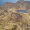
The foundations of three structures lie in the rough moorland SSW of the Bull Loch. 'A' is an oval setting of stones, some 15m x 8m. The walls, one course only, are about 1m wide. The narrow door at the WSW is made of two orthostats, 2.1m x 2m. 'B': An oval setting of stones 13m x 8m rings the top of a small knoll which may be natural or may be partly built up. It is made of smaller stones than 'A'. It has no obvious door and there is a slight hollow in the centre. 'C', a circular setting of stones 20m x 22m, lies 200m NW of 'A' and 'B'. It is made of large stones. The entrance, 4.8m wide, is made of large orthostats.
I Hopkins 1972.
A rectangular stone-walled enclosure measuring 5.0m N-S by 4.0m transversely, with an entrance defined by two orthostats in the SW. About 25.0m to the south is a circular, stone-built enclosure 4.0m in diameter, occupying the top of a small, natural knoll.
NS 008 726 Two hundred metres SW of the above features is a circular stone-walled enclosure with a small pen built into its N side. None
of the features is of any great age and it seems likely that they
were associated with agriculture in this area in recent times. (cf. NS07SW 14).
Visited by OS (BS) 21 October 1976.
NS 009 727 Oval structures: Located on small knolls near foot of SE slope of Muclich Hill. There are the wall-footings of 3 oval buildings on neighbouring knolls. One built of large stones, with orthostats forming inner wall-face, and two forming the doorway in W gable. The walling is broad and substantial. The others are similar but less well preserved. No record. Perhaps associated with pig rearing (Gaelic: Muclich).
Information from Bute Natural History Society Deserted Settlement Survey (1991-9)
(RCAHMS WP000273)
NS 009 727 Site 183 Muclich Hill
On three neighbouring natural knolls on the lower slopes of Muclich Hill are footings of three oval buildings, with many orthostats facing the inside wall, and doorways in one of the gable ends. Possibly associated with pig rearing (see Site 182, NS07SW 43) or perhaps more conventional shielings. Dating uncertain. Two buildings were noted by Hopkins (1972, 16).
E Proudfoot and A Hannah 2000
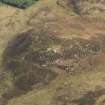
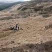
Two shieling-huts and what may be a pen or a store are situated on a narrow terrace on the SE flank of Muclich Hill, about 150m SE of the summit. The larger of the two huts measures 5m from NE to SW by 2m transversely within a low boulder wall and there is an entrance, flanked by orthostats, in the SW end. The hut has been set into the top of an oval mound measuring 11m from NE to SW by 8m transversely and up to 1m in height. The second hut, which has also been set into a mound, some 20m to the SW, measures 4m from NE to SW by 2m transversely within grass-grown wall-footings. An oval setting of boulders, measuring up to 1.7m across internally, which lies between the two huts, may be pen or some form of store. In rough ground immediately S of the huts there is a grass-grown bank. Two further shieling-huts may be indicated by mounds at NS 00909 72695 and NS 00903 72684, some 70m to the SW.
Visited by RCAHMS (GFG, LAD) 31 March 2009.
Field Visit (1972)
The foundations of three structures lie in the rough moorland SSW of the Bull Loch. 'A' is an oval setting of stones, some 15m x 8m. The walls, one course only, are about 1m wide. The narrow door at the WSW is made of two orthostats, 2.1m x 2m. 'B': An oval setting of stones 13m x 8m rings the top of a small knoll which may be natural or may be partly built up. It is made of smaller stones than 'A'. It has no obvious door and there is a slight hollow in the centre. 'C', a circular setting of stones 20m x 22m, lies 200m NW of 'A' and 'B'. It is made of large stones. The entrance, 4.8m wide, is made of large orthostats.
I Hopkins 1972.
Field Visit (21 October 1976)
A rectangular stone-walled enclosure measuring 5.0m N-S by 4.0m transversely, with an entrance defined by two orthostats in the SW. About 25.0m to the south is a circular, stone-built enclosure 4.0m in diameter, occupying the top of a small, natural knoll.
NS 008 726 Two hundred metres SW of the above features is a circular stone-walled enclosure with a small pen built into its N side. None
of the features is of any great age and it seems likely that they
were associated with agriculture in this area in recent times. (cf. NS07SW 14).
Visited by OS (BS) 21 October 1976.
Field Visit (1991 - 1999)
NS 009 727 Oval structures: Located on small knolls near foot of SE slope of Muclich Hill. There are the wall-footings of 3 oval buildings on neighbouring knolls. One built of large stones, with orthostats forming inner wall-face, and two forming the doorway in W gable. The walling is broad and substantial. The others are similar but less well preserved. No record. Perhaps associated with pig rearing (Gaelic: Muclich).
Information from Bute Natural History Society Deserted Settlement Survey (1991-9)
(RCAHMS WP000273)
NS 009 727 Site 183 Muclich Hill
On three neighbouring natural knolls on the lower slopes of Muclich Hill are footings of three oval buildings, with many orthostats facing the inside wall, and doorways in one of the gable ends. Possibly associated with pig rearing (see Site 182, NS07SW 43) or perhaps more conventional shielings. Dating uncertain. Two buildings were noted by Hopkins (1972, 16).
E Proudfoot and A Hannah 2000
Field Visit (31 March 2009)
Two shieling-huts and what may be a pen or a store are situated on a narrow terrace on the SE flank of Muclich Hill, about 150m SE of the summit. The larger of the two huts measures 5m from NE to SW by 2m transversely within a low boulder wall and there is an entrance, flanked by orthostats, in the SW end. The hut has been set into the top of an oval mound measuring 11m from NE to SW by 8m transversely and up to 1m in height. The second hut, which has also been set into a mound, some 20m to the SW, measures 4m from NE to SW by 2m transversely within grass-grown wall-footings. An oval setting of boulders, measuring up to 1.7m across internally, which lies between the two huts, may be pen or some form of store. In rough ground immediately S of the huts there is a grass-grown bank. Two further shieling-huts may be indicated by mounds at NS 00909 72695 and NS 00903 72684, some 70m to the SW.
Visited by RCAHMS (GFG, LAD) 31 March 2009.
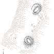
Measured Survey (14 October 2010 - 28 October 2010)
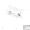
RCAHMS surveyed the shieling huts at Muclich Hill, Bute on 14 October 2010 with local volunteers Sue Hothersall and Chris Stuart-Moffat. The survey, undertaken with plane table and self-reducing alidade, produced a plan of two shieling huts at a scale of 1:200. The survey drawing was checked on-site on 28 October 2010.

