Scheduled Maintenance
Please be advised that this website will undergo scheduled maintenance on the following dates: •
Tuesday 3rd December 11:00-15:00
During these times, some services may be temporarily unavailable. We apologise for any inconvenience this may cause.
Bute, Ardnagave
Corn Drying Kiln (Period Unassigned), Farmstead (Period Unassigned)
Site Name Bute, Ardnagave
Classification Corn Drying Kiln (Period Unassigned), Farmstead (Period Unassigned)
Canmore ID 40488
Site Number NS07SW 22
NGR NS 00222 71275
Datum OSGB36 - NGR
Permalink http://canmore.org.uk/site/40488
- Council Argyll And Bute
- Parish North Bute
- Former Region Strathclyde
- Former District Argyll And Bute
- Former County Buteshire
NS07SW 22 00222 71275
There is a corn-drying kiln at the deserted farm at Ardnagave.
I D Milligan 1963.
Recorded during survey of deserted settlements, Isle of Bute: All sites are being measured and photographed, although a considerable number have still to be visited.
The majority of the settlements are post-medieval farm sites. Of several anomalous remains, some are earlier, while others, because of location and form are unlikely to be domestic structures.
The records are held in the Bute Museum, The basic list has been forwarded to NMRS.
Sponsors: Bute Antiq Natur Hist Soc; St Andrews Heritage Services.
Hannah and Proudfoot 1994.
NS 0022 7126 Settlement ruins: Located on dry sloping moorland 1km inland from Old Ferry Craig. Overgrown with heather. There is no nearby water. Substantial ruins of 3 houses, each with an adjacent enclosure and corn kiln. Oldest 5.8 x 3.3m internal, others are 12.5 x 4m and 10.5 x 3.5m with an extension 2 x 3.5m on upper end. There are traces of field system, with rig running N/S in the field below.
Information from Bute Natural History Society Deserted Settlement Survey (1991-9)
(RCAHMS WP000273)
NS 002 712 Site 173 Ardnagave
In a small lateral glen above the Altmore meadows lie the ruins of this little township, which was a butt of Kilmichael. Three houses survive as ruins, each with an adjacent yard, and there is also a well preserved corn-drying kiln. One of the houses still shows an alcove in the wall believed to have accommodated an outshot bed. The settlement is first attested by Roy (c1750), and was probably abandoned c1830.
Proudfoot and Hannah 2000
This farmstead occupies a small hanging valley on the SW flank of Ardnagave Hill, some 900m ENE of Kilmichael farmsteading. It comprises four rectangular buildings, a corn-drying kiln, and associated enclosures and cultivation remains on either side of a choked burn. The largest building (NS 00226 71252), which is situated on the E side of a small enclosure or yard, measures 13m from N to S by 5.7m transversely over walls 0.6m in thickness and up to 2.4m in height. It has opposed entrances in the side-walls and there is a byre-drain within its lower (S) end. A second, less well preserved building (NS 00224 71276), stands 10m to the N, in the SE corner of a small, roughly triangular enclosure. It measures 12.8m from N to S by 4.5m transversely over stone walls 0.7m in thickness. A bedneuk projects from the W side of the building and a short outshot is attached to its N end.
The third building (NS 00174 71223) is situated 50m SW of the first and is more ruinous still, measuring, 8m from NNW to SSE by 5m transversely over walls reduced to a rubble spread. The N end of the building has been let into the natural slope and a large accumulation of stone at the S end may indicate the presence of a kiln. The fourth building (NS 00169 71255) lies 50m W of the largest, on the SW side of a small enclosure. Rectangular on plan, it measures 10.5m from NW to SE by 5.5m transversely over walls reduced to grass-grown footings. The corn-drying kiln is situated immediately ENE of the third building. It measures about 5m in diameter by 1m in height overall and the bowl (about 2m in diameter) is partly filled with debris.
Ardnagave is depicted on Roy's Military Map (1747-55) and a contemporary estate plan (Foulis 1758-9). The latter shows two buildings and a yard surrounded by 'arable folds', mainly to the S and W. The same two buildings and yard, plus a head-dyke, are shown on Mackinlay's map of 1823. The depiction of the farmstead on the 1st edition of the OS 6-inch map is of three unroofed buildings and a yard (Argyllshire and Buteshire 1869, Sheet CXCIII).
Visited by RCAHMS (GFG, LAD) 1 April 2009.
Antiquarian Mapping (1747 - 1755)
Antiquarian Mapping (1758 - 1759)
Antiquarian Mapping (1780 - 1782)
Antiquarian Mapping (1823)
Field Visit (1864)
Field Visit (1963)
There is a corn-drying kiln at the deserted farm at Ardnagave.
I D Milligan 1963.
Field Visit (1991 - 1999)
NS 0022 7126 Settlement ruins: Located on dry sloping moorland 1km inland from Old Ferry Craig. Overgrown with heather. There is no nearby water. Substantial ruins of 3 houses, each with an adjacent enclosure and corn kiln. Oldest 5.8 x 3.3m internal, others are 12.5 x 4m and 10.5 x 3.5m with an extension 2 x 3.5m on upper end. There are traces of field system, with rig running N/S in the field below.
Information from Bute Natural History Society Deserted Settlement Survey (1991-9)
(RCAHMS WP000273)
NS 002 712 Site 173 Ardnagave
In a small lateral glen above the Altmore meadows lie the ruins of this little township, which was a butt of Kilmichael. Three houses survive as ruins, each with an adjacent yard, and there is also a well preserved corn-drying kiln. One of the houses still shows an alcove in the wall believed to have accommodated an outshot bed. The settlement is first attested by Roy (c1750), and was probably abandoned c1830.
Proudfoot and Hannah 2000
Field Visit (1 April 2009)
This farmstead occupies a small hanging valley on the SW flank of Ardnagave Hill, some 900m ENE of Kilmichael farmsteading. It comprises four rectangular buildings, a corn-drying kiln, and associated enclosures and cultivation remains on either side of a choked burn. The largest building (NS 00226 71252), which is situated on the E side of a small enclosure or yard, measures 13m from N to S by 5.7m transversely over walls 0.6m in thickness and up to 2.4m in height. It has opposed entrances in the side-walls and there is a byre-drain within its lower (S) end. A second, less well preserved building (NS 00224 71276), stands 10m to the N, in the SE corner of a small, roughly triangular enclosure. It measures 12.8m from N to S by 4.5m transversely over stone walls 0.7m in thickness. A bedneuk projects from the W side of the building and a short outshot is attached to its N end.
The third building (NS 00174 71223) is situated 50m SW of the first and is more ruinous still, measuring, 8m from NNW to SSE by 5m transversely over walls reduced to a rubble spread. The N end of the building has been let into the natural slope and a large accumulation of stone at the S end may indicate the presence of a kiln. The fourth building (NS 00169 71255) lies 50m W of the largest, on the SW side of a small enclosure. Rectangular on plan, it measures 10.5m from NW to SE by 5.5m transversely over walls reduced to grass-grown footings. The corn-drying kiln is situated immediately ENE of the third building. It measures about 5m in diameter by 1m in height overall and the bowl (about 2m in diameter) is partly filled with debris.
Ardnagave is depicted on Roy's Military Map (1747-55) and a contemporary estate plan (Foulis 1758-9). The latter shows two buildings and a yard surrounded by 'arable folds', mainly to the S and W. The same two buildings and yard, plus a head-dyke, are shown on Mackinlay's map of 1823. The depiction of the farmstead on the 1st edition of the OS 6-inch map is of three unroofed buildings and a yard (Argyllshire and Buteshire 1869, Sheet CXCIII).
Visited by RCAHMS (GFG, LAD) 1 April 2009.
Measured Survey (16 March 2010)
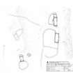
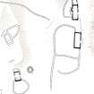
RCAHMS surveyed the farmstead at Ardnagave, Bute on 16 March 2010 with plane table and self-reducing alidade, producing a site plan at a scale of 1:500. The plan was redrawn in vector graphics software for publication (Geddes and Hale 2010, 39).


