
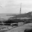
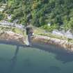
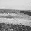
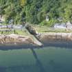
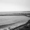
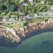
Corrie Harbour


Harbour (Period Unassigned)
Site Name Corrie Harbour
Classification Harbour (Period Unassigned)
Alternative Name(s) Firth Of Clyde
Canmore ID 40227
Site Number NS04SW 5
NGR NS 02541 43439
NGR Description Centred NS 02541 43439
Datum OSGB36 - NGR
Permalink http://canmore.org.uk/site/40227


- Council North Ayrshire
- Parish Kilbride
- Former Region Strathclyde
- Former District Cunninghame
- Former County Buteshire
NS04SW 5 centred 02541 43439
Harbour [NAT]
OS (GIS) MasterMap, March 2010.
Not to be confused with harbour (jetty) at NS 02615 42744, for which see NS04SW 29.
(Location cited as NS 024 437). Harbour, Corrie, 18th to 19th century. The quayed mouth of a stream, with an indented portion the right size for a small sailing vessel.
J R Hume 1977.

