
Arran, Monamore Glen


Burial Cairn (Bronze Age)
Site Name Arran, Monamore Glen
Classification Burial Cairn (Bronze Age)
Canmore ID 40102
Site Number NS02NW 4
NGR NS 0126 2977
Datum OSGB36 - NGR
Permalink http://canmore.org.uk/site/40102


- Council North Ayrshire
- Parish Kilbride
- Former Region Strathclyde
- Former District Cunninghame
- Former County Buteshire
NS02NW 4 0126 2977.
(NS 0127 2975) Cairn (NR).
OS 6" map, (1924)
A dilapidated mound of earth and stones about 66ft by 2 1/2ft high and about 50ft in breadth at its W end narrowing to a rounded point at the E. The N corner is marked by a boulder about 2ft high (ONB 1864). The NSA (1845), stating that this cairn is over 200ft in circumference, adds that a considerable part of it was carried away for building purposes two years ago (ie 1835 or 1838) when several cists, each composed of six stones, were found.
NSA 1845; Name Book 1864.
By the side of the mill dam, is the site of a cairn, now measuring 16 x 17ft. At its W end is an irregular upright stone 2ft 6ins high.
J Balfour 1910.
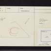
NS 0126 2977. The cairn stands on a level terrace above Monamore Burn and survives as a tapered turf-covered oblong mound orientated NE - SW with maximum dimensions of 21.0m NE-SW by 18.0m NW - SE and a height of 1.5m on the NE side. Surrounded by a sheep fold complex, its shape and appearance are the result of many mutilations and robbing. The single 1.0m high standing stone is within the suggested limits of the cairn material, but its purpose is not obvious.
Surveyed at 1:10 000.
Visited by OS (J R L) 31 October 1977.
Note (11 June 2019 - 13 June 2019)
The location, classification and period of this site have been reviewed.
HES Survey and Recording 11-13 June 2019

