
Following the launch of trove.scot in February 2025 we are now planning the retiral of some of our webservices. Canmore will be switched off on 24th June 2025. Information about the closure can be found on the HES website: Retiral of HES web services | Historic Environment Scotland
Cnoc Pollphail, Low Stillaig


Standing Stone(S) (Prehistoric)
Site Name Cnoc Pollphail, Low Stillaig
Classification Standing Stone(S) (Prehistoric)
Canmore ID 39842
Site Number NR96NW 5
NGR NR 9316 6835
Datum OSGB36 - NGR
Permalink http://canmore.org.uk/site/39842


- Council Argyll And Bute
- Parish Kilfinan
- Former Region Strathclyde
- Former District Argyll And Bute
- Former County Argyll
NR96NW 5 9316 6835.
(NR 9316 6835) Standing Stones (NR)
OS 6" map, Argyllshire, 2nd ed., (1900)
Two stones, 25' apart centre to centre. The northernmost is 10 1/2' high, and the other is 2'3" high. The broken part of the smaller stone is said to have been used as a lintel for a byre at Low Stallaig.
A standing stone in this vicinity - perhaps one of the above - is said to have Ogham lettering on it, but this can be seen only when the light is exactly right (Paterson 1970).
M Paterson 1970; Information from J G Scott to OS, June 1951.
As described. No markings were visible on the day of visit.
Visited by OS (D W R) 1 November 1972.
No change to field report of 1 November 1972.
Surveyed at 1/10,000.
Visited by OS (B S) 6 October 1976.
Field Visit (17 September 1942)
This site was included within the RCAHMS Emergency Survey (1942-3), an unpublished rescue project. Site descriptions, organised by county, vary from short notes to lengthy and full descriptions and are available to view online with contemporary sketches and photographs. The original typescripts, manuscripts, notebooks and photographs can also be consulted in the RCAHMS Search Room.
Information from RCAHMS (GFG) 10 December 2014.
Field Visit (May 1985)
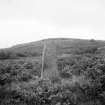
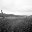
Two stones stand in open moorland 660m NNE of Low Stillaig commanding extensive views westwards across Loch Fyne. Aligned NNW and SSE, stone A is about 2.9m high and now leans at a distinct angle to the NNW; it would originally have been about 3.15m high and has straight tapering sides rising from a basal girth of 1.93m to a pointed top. Stone B is quadrangular at the base (0.5m by 0.35m), but has been broken off at a height of 0.65m. The missing part is said to have been used as a lintel for a byre at Low Stillaig.
Visited May 1985
RCAHMS 1988
Measured Survey (May 1985)
RCAHMS surveyed Cnoc Pollphail, Low Stillaig standing stones on May 1985 with plane-table and alidade producing a plan at a scale of 1:100. The plan of the standing stones was redrawn in ink and published at a scale of 1:250 (RCAHMS 1988a, 131).

