|
Photographs and Off-line Digital Images |
E 43993 CN |
RCAHMS Aerial Photography |
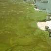
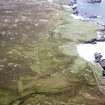
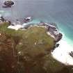
Oblique aerial view centred on the remains of the township and lazy beds with the remains of the radar station and possible nunnery adjacent, taken from the NNE. |
28/9/2004 |
Item Level |
|
|
Photographs and Off-line Digital Images |
E 43994 CN |
RCAHMS Aerial Photography |
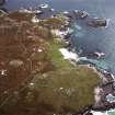
Oblique aerial view centred on the remains of the township and lazy beds with the remains of the radar station and possible nunnery adjacent, taken from the WSW. |
28/9/2004 |
Item Level |
|
|
Photographs and Off-line Digital Images |
E 43995 CN |
RCAHMS Aerial Photography |
Oblique aerial view centred on the remains of the township and lazy beds with the remains of the radar station and possible nunnery adjacent, taken from the WSW. |
28/9/2004 |
Item Level |
|
|
Photographs and Off-line Digital Images |
E 54810 CN |
RCAHMS Aerial Photography |
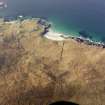
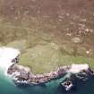
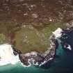
Oblique aerial view centred on the remains of the township and lazy beds with the remains of the radar station and possible nunnery adjacent, taken from the E. |
28/9/2004 |
Item Level |
|
|
Photographs and Off-line Digital Images |
E 54811 CN |
RCAHMS Aerial Photography |
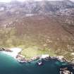
Oblique aerial view centred on the remains of the township and lazy beds with the remains of the radar station and possible nunnery adjacent, taken from the NE. |
28/9/2004 |
Item Level |
|
|
Photographs and Off-line Digital Images |
E 54812 CN |
RCAHMS Aerial Photography |
Oblique aerial view centred on the remains of the township and lazy beds with the remains of the radar station and possible nunnery adjacent, taken from the N. |
28/9/2004 |
Item Level |
|
|
Photographs and Off-line Digital Images |
E 54814 CN |
RCAHMS Aerial Photography |
Oblique aerial view centred on the remains of the township and lazy beds with the remains of the radar station and possible nunnery adjacent, taken from the NW. |
28/9/2004 |
Item Level |
|
|
Manuscripts |
MS 2626 |
|
Report: Lewis coastal chapel-sites survey: topographic survey 2005. (Glasgow University Viking and Early Settlement Archaeological Research Project). |
2006 |
Item Level |
|
|
Manuscripts |
MS 2384 |
|
Report: Lewis coastal chapel-sites survey 2004/5. (Glasgow University Viking and Early Settlement Archaeological Research Project).
|
2005 |
Item Level |
|
 |
On-line Digital Images |
SC 1171775 |
RCAHMS Aerial Photography |
Oblique aerial view centred on the remains of the township and lazy beds with the remains of the radar station and possible nunnery adjacent, taken from the NNE. |
28/9/2004 |
Item Level |
|
 |
On-line Digital Images |
DP 110798 |
RCAHMS Aerial Photography Digital |
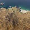
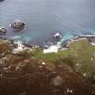
Oblique aerial view of the remains of the head dykes, lazy beds and buildings at Mealista, taken from the E. |
15/11/2011 |
Item Level |
|
 |
On-line Digital Images |
DP 110799 |
RCAHMS Aerial Photography Digital |
Oblique aerial view of the remains of the head dykes, lazy beds and buildings at Mealista, taken from the ENE. |
15/11/2011 |
Item Level |
|
 |
Digital Files (Non-image) |
WP 003958 |
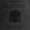
Publications by the Royal Commission on the Ancient and Historical Monuments of Scotland |
Ninth report with inventory of monuments and constructions in the Outer Hebrides, Skye and the Small Isles |
1928 |
Item Level |
|
 |
On-line Digital Images |
SC 1691826 |
RCAHMS Aerial Photography |
Oblique aerial view centred on the remains of the township and lazy beds with the remains of the radar station and possible nunnery adjacent, taken from the NNE. |
28/9/2004 |
Item Level |
|
 |
On-line Digital Images |
SC 1691827 |
RCAHMS Aerial Photography |
Oblique aerial view centred on the remains of the township and lazy beds with the remains of the radar station and possible nunnery adjacent, taken from the WSW. |
28/9/2004 |
Item Level |
|
 |
On-line Digital Images |
SC 1691828 |
RCAHMS Aerial Photography |
Oblique aerial view centred on the remains of the township and lazy beds with the remains of the radar station and possible nunnery adjacent, taken from the WSW. |
28/9/2004 |
Item Level |
|
 |
On-line Digital Images |
SC 1691833 |
RCAHMS Aerial Photography |
Oblique aerial view centred on the remains of the township and lazy beds with the remains of the radar station and possible nunnery adjacent, taken from the E. |
28/9/2004 |
Item Level |
|
 |
On-line Digital Images |
SC 1691834 |
RCAHMS Aerial Photography |
Oblique aerial view centred on the remains of the township and lazy beds with the remains of the radar station and possible nunnery adjacent, taken from the NE. |
28/9/2004 |
Item Level |
|
 |
On-line Digital Images |
SC 1691835 |
RCAHMS Aerial Photography |
Oblique aerial view centred on the remains of the township and lazy beds with the remains of the radar station and possible nunnery adjacent, taken from the N. |
28/9/2004 |
Item Level |
|
 |
On-line Digital Images |
SC 1691837 |
RCAHMS Aerial Photography |
Oblique aerial view centred on the remains of the township and lazy beds with the remains of the radar station and possible nunnery adjacent, taken from the NW. |
28/9/2004 |
Item Level |
|
 |
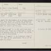
On-line Digital Images |
SC 2344928 |
Records of the Ordnance Survey, Southampton, Hampshire, England |
Lewis, Mealista, NA92SE 1, Ordnance Survey index card, Recto |
c. 1958 |
Item Level |
|
 |
On-line Digital Images |
SC 2344929 |
Records of the Ordnance Survey, Southampton, Hampshire, England |
Lewis, Mealista, NA92SE 1, Ordnance Survey index card, Recto |
c. 1958 |
Item Level |
|
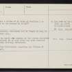 |
On-line Digital Images |
SC 2344930 |
Records of the Ordnance Survey, Southampton, Hampshire, England |
Lewis, Mealista, NA92SE 1, Ordnance Survey index card, page number 2, Verso |
c. 1958 |
Item Level |
|
|
All Other |
551 166/1/1 |
Records of the Ordnance Survey, Southampton, Hampshire, England |
Archaeological site card index ('495' cards) |
1947 |
Sub-Group Level |
|


