|
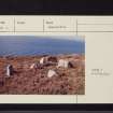
Photographs and Off-line Digital Images |
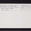
A 78961 CN |
Records of the Ordnance Survey, Southampton, Hampshire, England |
General view |
13/10/1977 |
Item Level |
|
 |
On-line Digital Images |
SC 1590313 |
Records of the Ordnance Survey, Southampton, Hampshire, England |
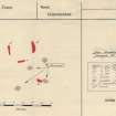
Plan, copied from Ordnance Survey Record Card |
13/10/1977 |
Item Level |
|
 |
On-line Digital Images |
SC 1946649 |
Historic Environment Scotland |
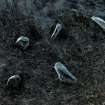
Oblique view of Leacach Bhreac stone setting created from laser scan data |
1/2020 |
Item Level |
|
|
Digital Files (Non-image) |
GV 007599 |
Historic Environment Scotland |
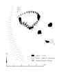
Plan of Leacach Bhreac stone settings |
1/2020 |
Item Level |
|
 |
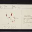
On-line Digital Images |
SC 1963756 |
Historic Environment Scotland |
Plan of Leacach Bhreac stone settings |
1/2020 |
Item Level |
|
 |
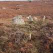
On-line Digital Images |
DP 326700 |
Historic Environment Scotland |
View from N |
31/10/2019 |
Item Level |
|
 |
On-line Digital Images |
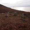
DP 326701 |
Historic Environment Scotland |
View from E |
31/10/2019 |
Item Level |
|
 |
On-line Digital Images |
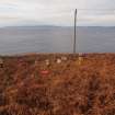
DP 326702 |
Historic Environment Scotland |
View from N |
31/10/2019 |
Item Level |
|
 |
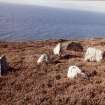
On-line Digital Images |
DP 326703 |
Historic Environment Scotland |
View from NE |
31/10/2019 |
Item Level |
|
 |
On-line Digital Images |
DP 326704 |
Historic Environment Scotland |
View from SE |
31/10/2019 |
Item Level |
|
 |
On-line Digital Images |
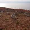
DP 326705 |
Historic Environment Scotland |
View from E |
31/10/2019 |
Item Level |
|
 |
On-line Digital Images |
DP 326706 |
Historic Environment Scotland |
View from W |
31/10/2019 |
Item Level |
|
|
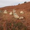
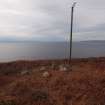
Photographs and Off-line Digital Images |
DP 326707 |
Historic Environment Scotland |
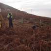
General view |
31/10/2019 |
Item Level |
|
|
Prints and Drawings |
DC 57808 |
Historic Environment Scotland |
Survey drawing. Plan of Leacach Bhreac, Arran, stone setting. |
31/10/2019 |
Item Level |
|
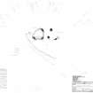 |
On-line Digital Images |
SC 2028240 |
Historic Environment Scotland |
Survey drawing. Plan of Leacach Bhreac, Arran, stone setting. |
31/10/2019 |
Item Level |
|
 |
On-line Digital Images |
SC 2261495 |
Records of the Ordnance Survey, Southampton, Hampshire, England |
General view |
13/10/1977 |
Item Level |
|
 |
On-line Digital Images |
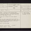
SC 2418705 |
Records of the Ordnance Survey, Southampton, Hampshire, England |
Arran, Leacach Bhreac, NR92NW 21, Ordnance Survey index card, Recto |
c. 1958 |
Item Level |
|
 |
On-line Digital Images |
SC 2418706 |
Records of the Ordnance Survey, Southampton, Hampshire, England |
Arran, Leacach Bhreac, NR92NW 21, Ordnance Survey index card, page number 1, Recto |
c. 1958 |
Item Level |
|
 |
On-line Digital Images |
SC 2418707 |
Records of the Ordnance Survey, Southampton, Hampshire, England |
Arran, Leacach Bhreac, NR92NW 21, Ordnance Survey index card, Recto |
c. 1958 |
Item Level |
|
 |
On-line Digital Images |
SC 2418708 |
Records of the Ordnance Survey, Southampton, Hampshire, England |
Arran, Leacach Bhreac, NR92NW 21, Ordnance Survey index card, page number 1, Recto |
c. 1958 |
Item Level |
|
 |
On-line Digital Images |
SC 2418709 |
Records of the Ordnance Survey, Southampton, Hampshire, England |
Arran, Leacach Bhreac, NR92NW 21, Ordnance Survey index card, page number 2, Verso |
c. 1958 |
Item Level |
|
|
Digital Files (Non-image) |
TM 002335 |
Historic Environment Scotland |
Leacach Bhreac stone setting: Laser scan data collected to record the shape of the cave and the locations of the carvings |
31/10/2019 |
Item Level |
|
|
All Other |
551 166/1/1 |
Records of the Ordnance Survey, Southampton, Hampshire, England |
Archaeological site card index ('495' cards) |
1947 |
Sub-Group Level |
|


