
Following the launch of trove.scot in February 2025 we are now planning the retiral of some of our webservices. Canmore will be switched off on 24th June 2025. Information about the closure can be found on the HES website: Retiral of HES web services | Historic Environment Scotland
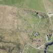
Dunadd


Cup And Ring Marked Rock (Prehistoric)(Possible), Cup Marked Rock (Prehistoric)(Possible)
Site Name Dunadd
Classification Cup And Ring Marked Rock (Prehistoric)(Possible), Cup Marked Rock (Prehistoric)(Possible)
Canmore ID 39597
Site Number NR89SW 4
NGR NR 83770 93559
Datum OSGB36 - NGR
Permalink http://canmore.org.uk/site/39597


- Council Argyll And Bute
- Parish Kilmichael Glassary
- Former Region Strathclyde
- Former District Argyll And Bute
- Former County Argyll
NR89SW 4 8377 9356.
NR 837 936. A cup and ring mark is situated on the NE side of Dunadd, overlooking the present farm and the cottage E of the site, c. 40' above the latter, and is passed if the NE route of ascent is used. A single cup, 2" in diameter, is surrounded by a roughly pecked ring, average diameter 11", carved on a rough surface and only visible in favourable conditions. There is also a single cup, 5" x 7" x c. 3" deep, cut on the flat surface of smooth rock below the S entrance to the main enclosure and on the lowest natural terrace on S of the hill.
Source: M Campbell 1965.
NR 8377 9356: The markings on the rock to the NE are indistinct and similar to natural marks in the area. Not an antiquity. The single cup could not be located though its size is more suggestive of a "knocking stone".
Visited by OS (DWR) 26 April 1973.
Field Visit (July 1980)
At various points outside the fort on the S and E, the rock outcrop bears pecked markings of prehistoric date: a flat outcrop at the base of the rocky massif on the S (f) bears a cup-marking, which measures 150mm in diameter and 50mm in depth; on a flat rock surface (g) a little o the E of the entrance there is a rather more oval cup-marking, 80mm by 70mm and 40mm deep; on an outcrop 40m to the ENE of g and a little to the NNW of the modern entrance wicket-gate, there is a third cup measuring 70mm in diameter and 20mm in depth within an oval ‘ring’ 380mm by 320mm overall and up to 50mm broad.
RCAHMS 1988, visited July 1980
[see RCAHMS 1988, fig. 153A for location of f and g]
Watching Brief (19 March 2014)
NR 8378 9354 A watching brief was maintained, on 19 March 2014, during the replacement of an information board. There were no finds or features of archaeological significance.
Archive: RCAHMS (intended)
Funder: Historic Scotland
Gordon Ewart – Kirkdale Archaeology
(Source: DES)
Note (27 February 2019)
Date Fieldwork Started: 27/02/2019
Compiled by: ScRAP
Location Notes: Although an extensive search was undertaken in the field, supported by a variety of existing documentary evidence from numerous sources, none of the three previously record cup or cup and ring markings reported at Dunadd were traceable.

