
Ballymeanoch


Barrow (Prehistoric)
Site Name Ballymeanoch
Classification Barrow (Prehistoric)
Canmore ID 39495
Site Number NR89NW 51
NGR NR 83522 96373
Datum OSGB36 - NGR
Permalink http://canmore.org.uk/site/39495


- Council Argyll And Bute
- Parish Kilmichael Glassary
- Former Region Strathclyde
- Former District Argyll And Bute
- Former County Argyll
NR89NW 51 83522 96373
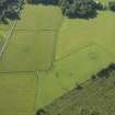
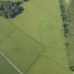
(NR 835 964) A grassy mound c. 90' in diameter by 3' high, close to the road at Ballymeanoch had a small section dug into it by Craw. The mound consisted chiefly of earth, with a large number of irregularly placed boulders. A charcoal layer was found on the original ground surface, but nothing else was found, as far as the excavation went.
J H Craw 1929; M Campbell and M Sandeman 1964
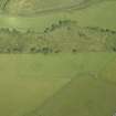
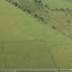
NR 8353 9637. Situated on flat arable ground this turf-covered mound, artificial in appearance, is the probably remains of a denuded cairn. It has a maximum diameter of 26.0m and a high stony content.
Surveyed at 1/2500.
Visited by OS (IA) 3 May 1973
NR 8352 9637. A turf-covered mound 30.0m in diameter and 1.4m high. Except for a small heap of large stones in the SW quadrant (possibly modern field clearance) no other stone is evident. The apparent lack of stone seems to preclude this from being a cairn, but as it is obviously artificial, it seems likely that it is the remains of a barrow.
Surveyed at 1/10,000.
Visited by OS (TRG) 1 April 1977
Field Visit (June 1979)
Situated between the public road and the henge monument (NR89NW 18), there is a large turf-covered mound, which appears to be a prehistoric barrow; measuring about 30 m in diameter and 1.4 m in height, it was the subject of exploratory excavation by Craw in 1928, who showed that it 'consisted chiefly of earth, but a large number of boulders irregularly placed was met with'. Beneath the boulders, at a depth of about 1 m, a layer of charcoal covered the old ground surface, but no cists or burials were encountered (Craw 1929, 189; Campbell and Sandeman 1964).
Visited June 1979
RCAHMS 1988

