Inverneill
Road Bridge (18th Century)
Site Name Inverneill
Classification Road Bridge (18th Century)
Canmore ID 39418
Site Number NR88SW 10
NGR NR 8486 8147
Datum OSGB36 - NGR
Permalink http://canmore.org.uk/site/39418
- Council Argyll And Bute
- Parish South Knapdale
- Former Region Strathclyde
- Former District Argyll And Bute
- Former County Argyll
Field Visit (March 1985)
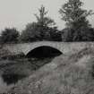
This bridge, which until 1939 carried the A83 close to the shore of Whitehouse Bay, crosses the Inverneil Burn on a single segmental arch of 13.6m span. It is constructed of random rubble masonry with radially set slab-voussoirs 0.7m long and, within parapets 1m high and 0.45m wide, the crown of the carriageway rises to a height of 5m above the bed of the burn. There are angled approaches from N and S. This is probably the bridge, across the 'Water of Inverneil', for which the Commissioners of Supply in 1768 granted £60towards the estimated cost of £65. It appears to have been completed in 1770 (en.1).
RCAHMS 1992, visited March 1985


