
Following the launch of trove.scot in February 2025 we are now planning the retiral of some of our webservices. Canmore will be switched off on 24th June 2025. Information about the closure can be found on the HES website: Retiral of HES web services | Historic Environment Scotland
Fair Isle, Pund


Burnt Mound (Prehistoric), Planticrub (19th Century)(Possible)
Site Name Fair Isle, Pund
Classification Burnt Mound (Prehistoric), Planticrub (19th Century)(Possible)
Alternative Name(s) Fair Isle, Site 230
Canmore ID 3937
Site Number HZ27SW 8
NGR HZ 20700 71613
Datum OSGB36 - NGR
Permalink http://canmore.org.uk/site/3937


- Council Shetland Islands
- Parish Dunrossness
- Former Region Shetland Islands Area
- Former District Shetland
- Former County Shetland
HZ27SW 8 2070 7161
See also HZ27SW 4.
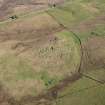
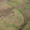
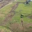
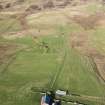
Area: HZ 206 715) Two mounds of burnt stones lie about 150 yards north of Pund. (In addition to no.1196 - Burnt Mound - HZ27SW 4).
RCAHMS 1946, visited 1930.
HZ 2068 7161. Two small turf-covered mounds of burnt stones set close together and both 1.0m high.
Surveyed at 1/2500.
Visited by OS(WDJ) 1 June 1968.
Burnt mound (or possibly two burnt mounds) quarried at centre. Total dimensions c.17 x 9m, with maximum surviving height c.1.5m. Composition of small burnt stones.
Individual dimensions, to N c.8.5 x 7.5m and to S c.9 x 8m. Royal Commission inventory (RCAHMS 1946 no. 1200) denotes site as representing two mounds although it seems equally likely that present form is result of quarrying from the centre of a single large mound.
J R Hunter, 1984.
One unroofed structure, which may be a planticrub located on the site of the burnt mound, is depicted on the 1st edition of the OS 6-inch map (Orkney and Shetland (Shetland) 1881, sheet lxix), but it is not shown on the current edition of the OS 1:10000 map (1973).
Information from RCAHMS (AKK) 21 March 2001.
Field Visit (19 August 1930)
Pund. There are two burnt mounds about 150 yds N of Pund.
RCAHMS 1946, visited 19 August 1930
Field Visit (1 June 1968)
HZ 2068 7161. Two small turf-covered mounds of burnt stones set close together and both 1.0m high.
Surveyed at 1/2500.
Visited by OS(WDJ) 1 June 1968.
Field Visit (1984)
Burnt mound (or possibly two burnt mounds) quarried at centre. Total dimensions c.17 x 9m, with maximum surviving height c.1.5m. Composition of small burnt stones.
Individual dimensions, to N c.8.5 x 7.5m and to S c.9 x 8m. Royal Commission inventory (RCAHMS 1946 no. 1200) denotes site as representing two mounds although it seems equally likely that present form is result of quarrying from the centre of a single large mound.
J R Hunter, 1984.
Note (21 March 2001)
One unroofed structure, which may be a planticrub located on the site of the burnt mound, is depicted on the 1st edition of the OS 6-inch map (Orkney and Shetland (Shetland) 1881, sheet lxix), but it is not shown on the current edition of the OS 1:10000 map (1973).
Information from RCAHMS (AKK) 21 March 2001.

