
Caisteal Torr


Dun (Prehistoric)
Site Name Caisteal Torr
Classification Dun (Prehistoric)
Canmore ID 39025
Site Number NR77NE 7
NGR NR 7856 7807
Datum OSGB36 - NGR
Permalink http://canmore.org.uk/site/39025


- Council Argyll And Bute
- Parish South Knapdale
- Former Region Strathclyde
- Former District Argyll And Bute
- Former County Argyll
NR77NE 7 7856 7807.
(NR 7855 7806) Caisteal Torr (NR) Fort (NR)
OS 6" map, Argyllshire, 2nd ed., (1924)
Caisteal Torr occupies a small stop near the summit of a long steep ridge. A good deal of walling including a small citadel, but robbed for dykes and confused.
M Campbell and M Sandeman 1964.
The summit of Caisteal Torr is occupied by the remains of a circular dun measuring up to 13.0m in diameter. The severly ruined walls utilise natural rock to the N and S but are best preserved in the W where a wall survives up to 2.4m in width and is five courses high. Although no entrance is apparent, it was probably in the E, where the dun is most approachable. The sloping interior is featureless.
Surveyed at 1:10,000.
Visited by OS (IA) 20 June 1973.
NR 7856 7807. No change to the report of 20 June 1973.
Surveyed at 1/10,000.
Visited by OS (BS) 27 January 1977.
Field Visit (May 1983)
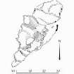
This dun and its outworks (Campbell and Sandeman 1964) are situated at the NE end of an elongated rocky ridge about 680m NE of Achahoish church.
Perched upon the craggy boss that forms the highest point of the ridge, the dun enjoys strong natural protection on all sides, but particularly on the NW, where there are sheer rock faces 13.5m high; relatively easy access to the summit is possible only on the NE by means of a sinuous route between the numerous outcrops.
The dun is roughly D-shaped on plan, measuring about 16m by 12m within a much-wasted drystone wall. Except on the W, where it has been destroyed by a collapse of the rock face, the wall survives as a heavy band of core material or a stony scarp, in which occasional outer facing-stones can still be seen. The best-preserved sector of the outer face is on the SSE, where it stands 1m high in six courses, although the lowest course lies as much as 3m below the level of the summit area. The entrance probably lay on the NE, where the weight of wall-debris is appreciably lighter.
The outworks, for the most part, comprise short lengths of drystone walling of relatively slight construction, drawn along the outer edge of rocky shelves lying below the dun on the NE and SW, their purpose being to impede immediate access to the summit; the lowest stretches on the ENE, however, have been constructed in a rather irregular fashion of peculiarly massive slabs and boulders - a feature of outworks at several prehistoric defensive sites in other parts of Argyll.
Visited May 1983
RCAHMS 1988
Measured Survey (3 May 1983)
RCAHMS surveyed Caisteal Torr dun on 03 May 1983 with plane-table and alidade producing a plan at a scale of 1:100. The plan of the dun was redrawn in ink and published at a scale of 1:250 (RCAHMS 1988a, 177).

