
Achadh Na Cille, Ardminish


Burial Ground (Medieval), Chapel (Medieval)
Site Name Achadh Na Cille, Ardminish
Classification Burial Ground (Medieval), Chapel (Medieval)
Canmore ID 38991
Site Number NR76SW 13
NGR NR 73875 60100
Datum OSGB36 - NGR
Permalink http://canmore.org.uk/site/38991


- Council Argyll And Bute
- Parish South Knapdale
- Former Region Strathclyde
- Former District Argyll And Bute
- Former County Argyll
NR76SW 13 7386 6009.
(NR 7385 6010) Chapel and Burial Ground (NR) (Site of) (Achadh na Cille) (NAT)
OS 6" map, (1924)
The remains of a chapel, situated within the walls of a burial ground, are situated a short way SE of the summit of Ardminish Hill. The walls of the chapel and burial ground are now nearly levelled. No tradition remains except that it was used as a place of burial by the inhabitants of Gigha and Islay. There are no signs of any graves except a small, nearly levelled cairn near the NE end of the chapel.
Name Book 1868.
Achadh na Cille: A small stony area, overgrown with elder bushes, with an oval enclosure 18' long at the SW corner. The enclosure has a probable entrance at NW, larger entrance at S, and may have a small hut against the N wall. Turf dyke surrounds the whole complex and extends to a dam on burn to W. The tradition quoted above may imply that a Gigha fisherman had been buried here - but local custom is to bury drowned men at sea.
M Campbell and M Sandeman 1964.
The remains consist of a denuded earth-and-stone dyke 2.0m wide, enclosing an area 18.0m N-S by 15.0m. Abutting the W wall of the enclosure are the remains of a sub-square stone-walled building measuring 6.0m E-W by 5.0m with an entrance in the S. The building has slightly rounded corners with walls 1.4m thick and 1.2m high. The whole is heavily overgrown with bracken, making an accurate interpretation difficult, but the tradition that men from Gigha were buried here was confirmed locally, and Mr Coates (Carse) states that the bay to the S is known as the Bay of Coffins.
Surveyed at 1:10,000.
Visited by OS (I A) 4 July 1973.
NR 7388 6009. The remains of a small building within an associated pentagonal enclosure, generally as described. The size, shape and substantial nature of these remains in comparison with nearby field walls, suggest them to be those of a chapel and burial ground rather than a dwelling. The chapel is situated within the burial ground, and not against the west wall, as stated in the previous report, and has what appears to be a relatively modern sheep pen built into its NE corner. The burial ground occupies an area approximately 30m by 30m.
Surveyed at 1/10,000.
Visited by OS (B S) 9 March 1977.
See also Archaeology Notes.
Field Visit (May 1985)
This site lies in a valley on the SE flank of Ardminish Hill, 0.7km S of the deserted settlement of Ardminish, and 430m NE of a small inlet on the shore of the Sound of Jura. It comprises a pentagonal enclosure measuring about 35m from N to S by 30m transversely, bounded by a turf-and-stone dyke 1.8m in maximum thickness. The NW side of the enclosure is formed by a low rock-face, surmounted at its SW end by walling which returns across an area of boggy ground marking the position of a seasonal stream. In the E section the dyke has been only a revetment at the base of ground sloping from the NE, but elsewhere lengths of both inner and outer facing-stones survive, in places to a height of 1m. The entrance, in the SW section, appears to have been enclosed within a subrectangular structure of later date of which only slight traces now remain, and there are also traces of a small circular feature against the inner face of the boundary-wall immediately N of the entrance.
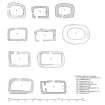
In the S part of the enclosure, close to the entrance, there is a subrectangular building measuring 5.6m from ENE to WSW by 4.2m transversely within turf-grown walls up to 0.8m in height. Its entrance was in the W wall, and a twinning pen has been built in the SE angle at a recent date. A low stony mound about 2.5m in diameter, near the E boundary wall, is presumably the 'small cairn, now nearly level' that was recorded in 1868 (en.1*). The site is indicated as an embanked oval, named 'Tayintagart' (Tigh an t-Sagairt, 'the Priest's House'), on a farm-plan of 1780 (en.2), but only the name Achadh na Cilte (‘Field of the Burial-ground') was recorded by the Ordnance Survey in 1868 (en.3) Although no dedication has been preserved, the building and enclosure resemble other chapels and burial-grounds of probable Early Christian date in Argyll.
RCAHMS 1992, visited May 1985
Measured Survey (14 May 1985)
RCAHMS surveyed Achadh na Cille chapel on 14 May 1985 with plane-table and alidade producing a site plan and plan at a scale of 1:400 and 1:100 respectively. The site plan was redrawn in ink and published at a scale of 1:1000 (RCAHMS 1992, 45). The plan of the chapel was also redrawn in ink and published at a scale of 1:250 as part of illustration of comparative plans of early chapels (RCAHMS 1992, 6A).

