
Carse


Standing Stone(S) (Prehistoric), Plate(S) (Bronze)(Period Unknown)
Site Name Carse
Classification Standing Stone(S) (Prehistoric), Plate(S) (Bronze)(Period Unknown)
Alternative Name(s) Loch Stornoway
Canmore ID 38987
Site Number NR76SW 1
NGR NR 7425 6163
NGR Description NR 7425 6163 and NR 7414 6166
Datum OSGB36 - NGR
Permalink http://canmore.org.uk/site/38987


- Council Argyll And Bute
- Parish South Knapdale
- Former Region Strathclyde
- Former District Argyll And Bute
- Former County Argyll
NR76SW 1 7425 6163 and 7414 6166.
(A and B: NR 7425 6163; C:NR 7414 6166) Standing Stones (NR)
OS 6" map, (1924)
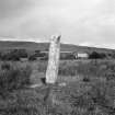
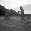
Two stones, A and B, stand 8' apart, in a line N-S, with C a short distance away. A measures 10' x 2'6" x 1'6"; B is 7'8" x 4' x 1'2", while C is 7'6" x 1'7" x 1'2". Fragments of Bronze Age bronze plates oshowing traces of small projecting embossed ornaments of Vandyke pattern, knobs, etc, found at the base of one of these stones, were donated to the National Museum of Antiquities of Scotland [NMAS] in 1864 by Mrs Campbell of Carse, but they have apparently disintegrated. (See also NR76SW 10).
M Campbell and M Sandeman 1964; Proc Soc Antiq Scot 1865.
As described.
Resurveyed at 1:2500.
Visited by OS (I A) 2 July 1973.
No change to the previous information.
Surveyed at 1/10,000.
Visited by OS (B S) 2 July 1973.
There is a prostrate stone 37.5m NE of the pair Partly buried; visible part measures 1.66x.40x.23m.
Information contained in letter from M A M Van Koek to OS, 1980. (Hoek?)
Barbed-and-tanged arrowhead of flint or chert found in tree-planting, 1988.
The Kist 1988.
Field Visit (21 September 1942)
This site was included within the RCAHMS Emergency Survey (1942-3), an unpublished rescue project. Site descriptions, organised by county, vary from short notes to lengthy and full descriptions and are available to view online with contemporary sketches and photographs. The original typescripts, manuscripts, notebooks and photographs can also be consulted in the RCAHMS Search Room.
Information from RCAHMS (GFG) 10 December 2014.
Field Visit (April 1984)
Situated in level fields SW of Carse House at the head of Loch Stornoway, there are three standing stones, a pair (A, B) and a single stone (C) 110m to the WNW (Campbell and Sandeman 1964). Stone A, which is aligned N and S, is 2.4m high, 1.25m broad and 0.4m thick; it rises to a rounded top on the N and to an angled top on the S. Stone B situated 2.5m to the S and is also aligned N and S, measures 0.65m by 0.45m at the base and 3.2m in height; it rises with straight sides for 1.5m, then its sides converge, finally outcurving to a point on the N. The surface has distinct veins of white quartz. The third stone (C) has been surrounded by field-gathered boulders, but some of the original packing-stones of the stone-hole are also visible. Aligned approximately NE and SW, and now leaning a little to the NE, it is lozenge-shaped at the base, measuring 1.85m in girth and rising to a height of 2.3m.
In 1864 'fragments of Bronze Plates found at the base of a Standing Stone on the estate of Carse' were presented to the Society of Antiquaries of Scotland, but they have not survived; they are decribed as showing 'traces of small projecting embossed ornaments of Vandyke pattern, and knobs etc' (Proc Soc Antiq Scot 1865).
Visited April 1984
RCAHMS 1988
Measured Survey (24 April 1984)
RCAHMS surveyed Carse standing stones on 24 April 1984 with plane-table and alidade producing a plan at a scale of 1:100. The plan of the standing stones was redrawn in ink and published at a scale of 1:250 (RCAHMS 1988a, 131).

