
Jura, Inverlussa, Killchianaig


Cemetery (Medieval), Chapel (Early Medieval) - (Medieval)(Possible), Cross Slab (Medieval)
Site Name Jura, Inverlussa, Killchianaig
Classification Cemetery (Medieval), Chapel (Early Medieval) - (Medieval)(Possible), Cross Slab (Medieval)
Canmore ID 38647
Site Number NR68NW 1
NGR NR 6447 8706
Datum OSGB36 - NGR
Permalink http://canmore.org.uk/site/38647


- Council Argyll And Bute
- Parish Jura
- Former Region Strathclyde
- Former District Argyll And Bute
- Former County Argyll
NR68NW 1 6447 8706.
(NR 6447 8706) Killchianaig (NAT)
OS 6" map (1900)
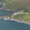
This name applies to an enclosed burial ground about 3/4 mile S of Ardlussa.
Name Book 1878
Kilchianaig graveyard is typical of burying places now on the sites of former Celtic churches.
D Budge 1960
There was a chapel of St Catan on Jura.
H Scott 1923
Kilchianaig (local spelling) graveyard is enclosed by a modern wall and is still in use. The earliest dated graveslabs are plain and undecorated, of the mid to late 18th century. There are no visible remains of a chapel, but it is traditionally believed that one existed here.
Surveyed at 1/10,000.
Visited by OS (JB) 11 May 1978
Field Visit (August 1974)
NR 644 870. There are no visible remains of a chapel and the burial-ground, which is of oblong plan, is enclosed by a wall of 19th-century date. The earliest identifiable memorial is a small roughly-shaped cruciform stone of local slate, 1.02m in height, which now serves as a headstone. The shaft tapers towards the head, where it has a width of 0.23m, while the maximum width across the arms is 0.40m; the base of the shaft is tapered for fixing into the ground. This stone is probably of medieval date. The earliest inscribed stone now visible is a recumbent slab of slate commemorating Malkum Buie, who died in 1746. There are also a number of headstones of local slate.
The chapel appears to have been dedicated to a saint bearing the Irish name Cianag.
Visited August 1974
RCAHMS 1984

