 |
On-line Digital Images |
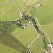
DP 108555 |
RCAHMS Aerial Photography Digital |
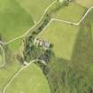
Oblique aerial view of South Beachmore centred on the roofless Free Church, taken from the ESE. |
9/8/2011 |
Item Level |
|
 |
On-line Digital Images |
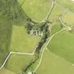
DP 108556 |
RCAHMS Aerial Photography Digital |
Oblique aerial view of South Beachmore centred on the roofless church, taken from the ENE. |
9/8/2011 |
Item Level |
|
 |
On-line Digital Images |
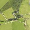
DP 108557 |
RCAHMS Aerial Photography Digital |
Oblique aerial view of South Beachmore centred on the roofless church, taken from the NNE. |
9/8/2011 |
Item Level |
|
 |
On-line Digital Images |
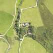
DP 108558 |
RCAHMS Aerial Photography Digital |
Oblique aerial view of South Beachmore centred on the roofless church, taken from the WSW. |
9/8/2011 |
Item Level |
|
 |
On-line Digital Images |
DP 108559 |
RCAHMS Aerial Photography Digital |
Oblique aerial view of South Beachmore centred on the roofless church, taken from the SW. |
9/8/2011 |
Item Level |
|
 |
On-line Digital Images |
SC 2415987 |
Records of the Ordnance Survey, Southampton, Hampshire, England |
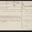
South Beachmore, NR64SE 13, Ordnance Survey index card, page number 1, Recto |
1958 |
Item Level |
|
|
All Other |
551 166/1/1 |
Records of the Ordnance Survey, Southampton, Hampshire, England |
Archaeological site card index ('495' cards) |
1947 |
Sub-Group Level |
|


