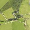
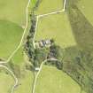
Accessibility

Font Size

100% 150% 200%

Background Colour

Default Contrast
Close Reset

South Beachmore

Motte (Medieval)(Possible)

Site Name South Beachmore

Classification Motte (Medieval)(Possible)

Canmore ID 38559

Site Number NR64SE 13

NGR NR 6833 4144

Datum OSGB36 - NGR

Permalink http://canmore.org.uk/site/38559

Ordnance Survey licence number AC0000807262. All rights reserved.
Canmore Disclaimer. © Bluesky International Limited 2025. Public Sector Viewing Terms

Toggle Aerial | View on large map

Digital Images

Oblique aerial view of South Beachmore centred on the roofless church, taken from the SW.
Oblique aerial view of South Beachmore centred on the roofless church, taken from the SW.South Beachmore, NR64SE 13, Ordnance Survey index card, page number 1, RectoOblique aerial view of South Beachmore centred on the roofless Free Church, taken from the ESE.Oblique aerial view of South Beachmore centred on the roofless church, taken from the ENE.Oblique aerial view of South Beachmore centred on the roofless church, taken from the NNE.Oblique aerial view of South Beachmore centred on the roofless church, taken from the WSW.

Administrative Areas

  • Council Argyll And Bute
  • Parish Killean And Kilchenzie
  • Former Region Strathclyde
  • Former District Argyll And Bute
  • Former County Argyll

Archaeology Notes

NR64SE 13 683 415.

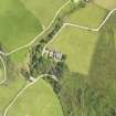
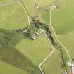
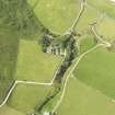
NR 683 415. A square motte or stack fort. A' Chleit.

Information from E J Talbot Ts 'Mottes'.

There is no trace of a motte in the area indicated. The only fortification identified is a dun on a stack some 700m to the south (see Dun Domhnuill NR64SE 20).

Visited by OS (N K B) 14 February 1978.

Not confirmed; but members of the Kintyre Society have stated a traditional medieval association in the area of the grid reference.

Information from E J Talbot, Glasgow University to OS, 10 November 1978.

References

MyCanmore Image Contributions


Contribute an Image

MyCanmore Text Contributions