
Kilchenzie, Old Parish Church And Churchyard


Burial Ground (Period Unassigned), Church (Period Unassigned), Churchyard (Period Unassigned)
Site Name Kilchenzie, Old Parish Church And Churchyard
Classification Burial Ground (Period Unassigned), Church (Period Unassigned), Churchyard (Period Unassigned)
Alternative Name(s) St Kenneth's Chapel
Canmore ID 38402
Site Number NR62SE 12
NGR NR 67372 24879
Datum OSGB36 - NGR
Permalink http://canmore.org.uk/site/38402


- Council Argyll And Bute
- Parish Killean And Kilchenzie
- Former Region Strathclyde
- Former District Argyll And Bute
- Former County Argyll
Field Visit (21 October 1959)
Surveyed at 1:2500.
Visited by OS (WDJ) 21 October 1959
Field Visit (1964)
Old Parish Church, Kilchenzie: This church stands in ruins within its graveyard upon a small knoll on the S side of the main Tarbert - Campbeltown road about 6 km NW of Campbeltown. The building is roofless, but the walls are fairly entire, except at the E end, where considerable portions of the N and S walls are missing. Most of the wall surfaces are very much overgrown, making detailed examination difficult. It is not known when it was finally abandoned for worship, but a drawing of 1833 (W Dobie 1833) indicates that the structure was then is very much the same condition as it is today. The dedication was to St Kenneth.
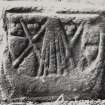
The church measures 22.5m from E to W by about 6.7m transversely over walls which have an average thickness of 0.94m at the E gable. The oldest part of the building is the W end, which may be ascribed to the 12th century. In all probability this portion originally existed as a free- standing-single chambered church having and overall length of 13.3m. This building was subsequently extended eastwards for a distance of 9.1m, the original E gable, however, being partially retained as a chancel division. The junction of the earlier and later work is clearly visible in the external masonry of the S wall, whose alignment changes abruptly at this point. To judge by the character of the window in the E gable-wall, the extension of the church was probably carried out some time in the 13th century. Few subsequent alterations appear to have been made to the fabric while the church remained in use for worship, but a number of burial-enclosures have been erected in and about the building within the past century or so. (The RCAHMS give architectural details). Captain White describes and illustrates a natural boulder in the vicinity of the church, on which the outline of a wheel-cross (Early Christian) is represented by means of a broad band or beading in low relief. This stone, 1.2m long cannot now be found.
A number of grave-slabs and other carved stones (also scheduled) dating from the 13th to 18th centuries, within and in the vicinity of the church are also described.
RCAHMS 1971, visited 1964
Reference (2001)
Medieval church of St Cainnech.
(1) In the churchyard, White recorded a boulder 1.2 m long, now lost. A Latin cross was outlined by a raised moulding, with ring-quadrants above the side-arms.
T P White 1873; I Fisher 2001.
Note
NR62SE 12 67372 24879
NMRS REFERENCE
Kilchenzie, Old Parish Church.
NMRS Drummond Drawings of 4 slabs at. AntMss.

