Jura, Keils
Field System (Period Unassigned), Field System (Period Unassigned), Head Dyke (Post Medieval), Township (Period Unassigned)
Site Name Jura, Keils
Classification Field System (Period Unassigned), Field System (Period Unassigned), Head Dyke (Post Medieval), Township (Period Unassigned)
Alternative Name(s) Kilearnadill; Cill Earnadill; Cathar Nan Clach
Canmore ID 38235
Site Number NR56NW 21
NGR NR 525 683
NGR Description Centred NR 525 683
Datum OSGB36 - NGR
Permalink http://canmore.org.uk/site/38235
- Council Argyll And Bute
- Parish Jura
- Former Region Strathclyde
- Former District Argyll And Bute
- Former County Argyll
NR56NW 21.00 centred 525 683
NR56NW 21.01 Cancelled: see NR56NW 41.01
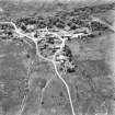
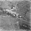
A township comprising one unroofed building, two partially roofed buildings, twenty-six roofed buildings, one of which is T-shaped, thirteen enclosures, a head-dyke and a field-system is depicted on the OS 1st edition 6-inch map (Argyllshire 1882, sheet cxcix). To the E of the buildings there is a large expanse of narrow strip-fields stretching from the Abhuinn a' Mhinisteir in the N to the school in the S.
Six unroofed, twelve roofed buildings, thirteen enclosures, a head-dyke and a field-system are shown on the current edition of the OS 1:10000 map (1981).
Information from RCAHMS (SAH), 4 November 1998.


