|
Photographs and Off-line Digital Images |
AG 8538 |
RCAHMS Aerial Photography |
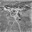
Jura, Keils, general.
Oblique aerial view from North. |
1977 |
Item Level |
|
|
Photographs and Off-line Digital Images |
AG 8539 |
RCAHMS Aerial Photography |
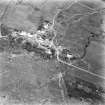
Jura, Keils, general.
Oblique aerial view from South. |
1977 |
Item Level |
|
|
Manuscripts |
MS 726/195 |
Records of CFA Archaeology Ltd, archaeologists, Musselburgh, East Lothian, Scotland |
Craighouse Water Treatment Works, Isle of Jura, Argyll and Bute, Archaeological Watching Brief. Data Structure Report No 532, by Ian Suddaby, CFA Archaeology Ltd, November 2000.
|
11/2000 |
Item Level |
|
|
Digital Files (Non-image) |
GV 005138 |
Records of the Royal Commission on the Ancient and Historical Monuments of Scotland (RCAHMS), Edinbu |
Adobe Illustrator illustration showing Strip fields at Keils, Jura Field-system plans extracted from OS first edition maps. Fig 13.3 from page 41 of "But the Walls Remained" |
2002 |
Item Level |
|
 |
On-line Digital Images |
SC 1683242 |
RCAHMS Aerial Photography |
Jura, Keils, general.
Oblique aerial view from North. |
1977 |
Item Level |
|
 |
On-line Digital Images |
SC 1723763 |
RCAHMS Aerial Photography |
Jura, Keils, general.
Oblique aerial view from South. |
1977 |
Item Level |
|
 |
On-line Digital Images |
SC 2415296 |
Records of the Ordnance Survey, Southampton, Hampshire, England |
Jura, Keils, NR56NW 21, Ordnance Survey index card, Recto |
c. 1958 |
Item Level |
|


