Pricing Change
New pricing for orders of material from this site will come into place shortly. Charges for supply of digital images, digitisation on demand, prints and licensing will be altered.
Upcoming Maintenance
Please be advised that this website will undergo scheduled maintenance on the following dates:
Thursday, 9 January: 11:00 AM - 3:00 PM
Thursday, 23 January: 11:00 AM - 3:00 PM
Thursday, 30 January: 11:00 AM - 3:00 PM
During these times, some functionality such as image purchasing may be temporarily unavailable. We apologise for any inconvenience this may cause.
Colonsay, Riasg Buidhe
Burial Ground (Medieval), Chapel (Early Medieval)
Site Name Colonsay, Riasg Buidhe
Classification Burial Ground (Medieval), Chapel (Early Medieval)
Alternative Name(s) Kiloran
Canmore ID 38212
Site Number NR49NW 8
NGR NR 4057 9544
Datum OSGB36 - NGR
Permalink http://canmore.org.uk/site/38212
- Council Argyll And Bute
- Parish Colonsay And Oronsay
- Former Region Strathclyde
- Former District Argyll And Bute
- Former County Argyll
Desk Based Assessment (2 August 1972)
NR49NW 8 4057 9544 and 4058 9542.
(NR 4059 9544) Burial Ground (NR)
OS 6" map, Argyllshire, 2nd ed., (1900)
The site of a chapel, still identifiable in 1881 as having measured 18' x 12' internally, with evidence of burials surrounding it.
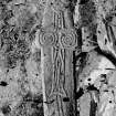
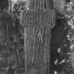
A sculptured 'face-cross' (see NR49NW 8.01) formerly stood at the E end of the chapel, after having served for some time as a cover for a well near the church it was removed to the garden of Colonsay House (NR 395 967), where it now stands beside Tobar Oran (see NR39NE 3.08; NR 3957 9680). About a foot of the shaft of the cross has been broken off, its original height having been 4'5". Thomas (1971) dates it to the 7th century. Other carved stones are said to have been built into neighbouring houses.
A round hole or basin cut in a rock in the middle of the burial ground is classed as a 'knocking stone' (Stevenson 1881).
W Stevenson 1881; A C Thomas 1971; J de V Loder 1935.
Information from OS (ES) 2 August 1972.
Field Visit (19 April 1974)
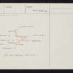
This site is now very ruined and little is to be seen except for the vague footings of the chapel which measure internally about 6.0m E-W by 3.8m. The entrance is not apparent.
The burial ground occupies the flat top of a low rocky ridge and is enclosed by the slight remains of a rubble wall. Within it are traces of a rectangular building oriented NW-SE, an uninscribed headstone and the knocking stone.
No carved stones are to be seen in the nearby houses but a small inscribed cross, on an ashlar block, measuring about 0.2m high, was found in the wall of a small building at NR 4058 9542 by Mr Alexander in January 1974; it remains in his possession (see NR49NW 8.02).
Surveyed at 1:10,000.
Visited by OS (JP) 19 April 1974; Information from D Alexander, Glen Cottage, Scalasaig.
Field Visit (May 1975)
NR 405 954. According to tradition (en.1) this site lies about 35m S of the main group of ruinous houses at Riasg Buidhe (RCAHMS 1984, No.426; NR49NW 26) and partly occupies the summit of a low rocky ridge which runs E-W. The vestiges of a transverse wall near the E end of the ridge may represent one of the boundaries of the cemetery, but there are no clearly identifiable remains of a chapel (en.2). The surface of the area in question is covered by a number of boulders, some of which may mark the positions of burials, and near the crest of the ridge there is a hollowed basin or mortar cut from a rock outcrop. There are the remains of a well in the gully immediately to the S of the burial-ground.
CARVED STONES. Number 1 (NR49NW 8.01) formerly stood 'at the east end of the chapel' (en.3), and was removed about 1870 to the grounds of Colonsay House, where it stands beside Tobar Odhrain (see NR39NE 3.08). Number 2 (NR49NW 8.02) was discovered in 1974, reused in the wall of an outbuilding close to the burial-ground (en.4), and is now in the National Museum of Antiquities of Scotland.
(1) Cruciform slab of local Torridonian flagstone, broken obliquely at the foot. It measures 1.37m in height by 0.36m across the arms, which have a maximum projection of 45mm. The slab is roughly triangular in section, having a maximum thickness of 120mm, while the side-arms are about 70 mm in thickness and are set towards the front. The back appears to be undressed, but the front, the edges and the backs of the arms show traces of peeking. The front is carved in low relief with a Latin cross, terminating at the foot in a fish-like forked tail, and at the top in a human face with prominent eyebrows, thick lips framing a down-turned mouth, and a ridge round the chin which may indicate a beard. The upper part of the slab is tapered so that the top of the head is carved in the round, the division being marked by a moulded collar which begins below the ears and continues onto the back, where it splits to enclose a lozenge-shaped hollow. The cross is outlined by a roll-moulding, continuous except where it adjoins the head, and the upper arm contains two parallel inner mouldings which divide into spirals in the side-arms. In the centre and lower arm of the cross a series of curving mouldings suggest the legs of a figure. The lower part of the slab, below the side-arms, is bordered by a pecked margin, (the engraving in Stevenson 1881 and Allen and Anderson 1903, which represents the margin returning horizontally at the foot of the slab, misrepresents Mackenzie's photograph of about 1870 showing the cross in its present condition) and a vertical band supporting the base of the cross is interrupted by the break at the foot of the slab. This carving is probably of 7th- or 8th-century date. For further discussion see p. 00. (NMAS cast (front only); photo by Revd J B Mackenzie in NMRS; PSAS, 15 (1880-1), 121-2; ibid, 34 (1899-1900), 331; ECMS, 3, p. 396 and fig. 413; Grieve, Colonsay, 2, fig. 27 opp. p.232; Loder, Colonsay, 78-9 and pl. xx; JRSAI, 90 (1960), 195-6 and fig. 1 d on p.193; Thomas, Early Christain Archaeology, fig. 61 on p.129).
(2) Part of a slab of Torridonian flagstone, possibly trimmed for reuse, and broken at the foot; it measures 0.37m in length by 0.14m in width and 65mm in thickness. On one face it bears the lightly pecked outline of a Latin cross, with a circular boss at the centre and a smaller circle at the end of each limb. Certain features, notably the irregular outline of the cross-shaft and the fact that the carving is not on the natural cleavage-plane but on a cut face, suggest that it is of fairly recent origin.
RCAHMS 1984, visited May 1975
(en.1) OS Name Book (en.2)Stevenson 1881; Loder 1935 (en.3) Stevenson 1881 (en.4) information from Mr D Alexander, formerly of Scalasaig
Note (19 October 2020)
A fragment of a carved stone, probably the lower part of a cross, was found lying on the ground by Peter Madden, Strontian, in August 2019 at NR 40559 95466, near the site of the chapel and burial ground of Riasg Buidhe, Colonsay (RCAHMS 1975, No. 389; Canmore 38212). Obliquely broken at the top, it measures approximately 0.85m in height by 0.25m and is about 8cm thick. The foot of the stone has been shaped into a tenon to sit in a socket and the face bears an inscribed design showing part of a cross shaft set within a pecked margin, and the top and left side of a rectangular pedestal..
Both the design and the dimensions of this new discovery suggest that it is the lower part of the well-known cross slab from the site (Ibid: Fisher 2001, 140; Canmore 319764), now located at Colonsay House. That fragment has been dated, on art-historical grounds, to the 7th or 8th century AD.
Information from HES (GFG) 19 October 2020.


