|
Prints and Drawings |
DC 40 |
Records of the Royal Commission on the Ancient and Historical Monuments of Scotland (RCAHMS), Edinbu |
Topographical map of islands Jura, Islay, Colonsay, Oronsay.
Inv.p.1. RCAHMS Copy in library.
(Currently missing - 31/5/96) |
|
Item Level |
|
|
Photographs and Off-line Digital Images |
DC 45 P |
Records of the Royal Commission on the Ancient and Historical Monuments of Scotland (RCAHMS), Edinbu |
Distribution map of forts, broch, duns. Inv. p.21. RCAHMS |
c. 1984 |
Item Level |
|
|
Photographs and Off-line Digital Images |
DC 287 P |
Records of the Royal Commission on the Ancient and Historical Monuments of Scotland (RCAHMS), Edinbu |
Plan ink 1:400 RCAHMS Inv. no. 225
Photographic copy |
1976 |
Item Level |
|
|
Prints and Drawings |
DC 288 |
Records of the Royal Commission on the Ancient and Historical Monuments of Scotland (RCAHMS), Edinbu |
PTS pencil 1:400 RCAHMS |
1976 |
Item Level |
|
 |
On-line Digital Images |
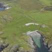
DP 095496 |
RCAHMS Aerial Photography Digital |
Oblique aerial view of the raised beaches, rig, clearance cairns, field boundaries and fish artwork at Port Sgibinis, taken from the SW |
1/9/2010 |
Item Level |
|
 |
On-line Digital Images |
SC 2415192 |
Records of the Ordnance Survey, Southampton, Hampshire, England |
Colonsay, Port An Obain, NR49NW 18, Ordnance Survey index card, Recto |
c. 1958 |
Item Level |
|
 |
On-line Digital Images |
SC 2415193 |
Records of the Ordnance Survey, Southampton, Hampshire, England |
Colonsay, Port An Obain, NR49NW 18, Ordnance Survey index card, Recto |
c. 1958 |
Item Level |
|
|
Prints and Drawings |
DC 45 |
Records of the Royal Commission on the Ancient and Historical Monuments of Scotland (RCAHMS), Edinbu |
Distribution map of forts, broch, duns. Inv. p.21. RCAHMS |
c. 1984 |
Item Level |
|
|
Prints and Drawings |
DC 287 |
Records of the Royal Commission on the Ancient and Historical Monuments of Scotland (RCAHMS), Edinbu |
Plan ink 1:400 RCAHMS Inv. no. 225 |
1976 |
Item Level |
|
|
All Other |
551 166/1/1 |
Records of the Ordnance Survey, Southampton, Hampshire, England |
Archaeological site card index ('495' cards) |
1947 |
Sub-Group Level |
|


