
Colonsay, Port An Obain


Dun (Later Prehistoric)
Site Name Colonsay, Port An Obain
Classification Dun (Later Prehistoric)
Canmore ID 38177
Site Number NR49NW 18
NGR NR 40940 99663
Datum OSGB36 - NGR
Permalink http://canmore.org.uk/site/38177


- Council Argyll And Bute
- Parish Colonsay And Oronsay
- Former Region Strathclyde
- Former District Argyll And Bute
- Former County Argyll
NR49NW 18 4094 9966
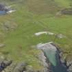
NR 4094 9966 Situated on the end of a rocky ridge overlooking Port an Obain are the remains of a small oval dun.
Its E side has been destroyed, but it originally measured 12.0m NE-SW by about 10.0m overall. On the W the outer face remains up to two courses high and the rubble core measures about 2.5m in width.
No entrance is visible and the interior is disturbed.
Surveyed at 1:2500.
Visited by OS (DWR), 7 April 1974.
Field Visit (June 1976)
NR 409 996. This dun is situated on a grassy knoll overlooking the shore at the S end of Port an Obain. Oval on plan, it measures 8m by 6m within a wall which has been reduced to a low stone mound. Several stretches of outer facing-stones can be seen on the N and W, reaching a maximum height of 0.5m in two courses. The position of the entrance is not certain, but it probably lay on the S. The interior has been much disturbed by rabbit-burrows.
RCAHMS 1984, visited June 1976.
Measured Survey (1976)
RCAHMS surveyed the dun at Port an Obain in 1976 at 1:400. The plan was redrawn in ink and published at a reduced scale (RCAHMS 1984, fig. 120A).

