
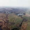
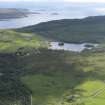
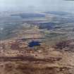
Islay, Loch Lossit, Eilean Mhic Iain


Building (17th Century) - (18th Century), Cruck Framed Building (17th Century) - (18th Century), Island Dwelling (Medieval) - (Post Medieval)
Site Name Islay, Loch Lossit, Eilean Mhic Iain
Classification Building (17th Century) - (18th Century), Cruck Framed Building (17th Century) - (18th Century), Island Dwelling (Medieval) - (Post Medieval)
Canmore ID 38111
Site Number NR46NW 18
NGR NR 40997 65269
Datum OSGB36 - NGR
Permalink http://canmore.org.uk/site/38111


- Council Argyll And Bute
- Parish Killarow And Kilmeny
- Former Region Strathclyde
- Former District Argyll And Bute
- Former County Argyll
Field Visit (August 1975)
NR409 652. This island is situated about 100m from the NE shore of Loch Lossit. It is composed of vertically bedded slates, visible at several points around the shore, and is heavily wooded as the result of ornamental planting of sycamores, but there is little undergrowth. The island measures 56m from N to S by 42m transversely, rising to a maximum height of about 3m, and it is encircled by a massive drystone wall having an average thickness of about 3.5m. This originally rose directly from the water, and the outer kerb of boulders is visible in several places, although overlain elsewhere by tumbled stone. The masonry is roughly constructed of igneous rubble, with occasional blocks of limestone; these materials are not native to the island, and must have been transported from the adjacent shores of the loch. The perimeter wall returns inwards at the N to form a boat-landing, protected on the E by a breakwater, but there is no evidence for a causeway, and the water separating the island from the shore is of considerable depth.
The perimeter wall is overlain for much of its length by an inner wall 1.2m thick, which stands in places to a height of about 1m. A well-formed opening in the inner wall is situated about 10m W of the boat-inlet, but its purpose is not apparent. Within the enclosure there are the remains of three rectangular buildings, two of which comprise an L-shaped block, although their chronological relationship is uncertain. One, measuring 6m by 2.4m within 0.8m walls, preserves a single cruck-recess in the E wall, but is so ruinous that the position of its entrance cannot be identified. The second building measures 8.4m by 3.4m internally and has a single entrance in the S, while the third building, whose NE angle is situated about 1.5m from the end-wall of the previous one, is slightly larger, but its side-walls are fragmentary. None of these buildings appears to be of great age, but at some points they overlie older footings.
The name Eilean Mhic Iain ('MacIan's island') appears in a feu-charter of the early 1570's and is shown in Pont's map as 'Elan na kean', while Martin, writing about 1690, classed 'Ilan Viceain', with the island in Loch Gorm, as fort. Since the perimeter wall is probably of late medieval date, it is possible that the island takes its name from John MacIan of Ardnamurchan, who in the 1490's became bailie of Islay and received large grants there. However, 'Lossit with the island' was grouped among church lands in the crown rental of 1509, and the feu-charter mentioned above was granted by John, Bishop of the Isles, as commendator of Iona Abbey, to Hector, son of ?Allan MacLean, bailie of ?the Rinns. The grant comprised the extensive Iona Abbey lands of Moychilis, including 'Lossett with the ile their of callit Ellan Moyborg alias ellan Vekkayne', and Loch Lossit can therefore be identified with Monro's 'Loch Moyburg, quhairin thair lyis an Ile pertaining to the Bishops of the Iles'. The surviving buildings on the island are probably of 17th- or 18th-century date, and the inner perimeter wall may have been constructed at the same period.
RCAHMS 1984, visited August 1975.
Measured Survey (1975)
RCAHMS surveyed the island-dwelling at Eilean Mhic Iain at a scale of 1:200. The plan was redrawn in ink and published at the reduced scale of 1:1000 (RCAHMS 1984, fig. 154A).
Field Visit (19 April 1979)
A minor deserted settlement comprising the ruins of three rectangular buildings, the largest 9m by 3.3m, which survive to a maximum height of 0.9m. The island, which is natural, has a wall drawn around its periphery.
OS field visit (NKB) 19 April 1979.

