Colonsay, Dun Gallain
Fort (Later Prehistoric)
Site Name Colonsay, Dun Gallain
Classification Fort (Later Prehistoric)
Canmore ID 37978
Site Number NR39SW 1
NGR NR 3486 9314
Datum OSGB36 - NGR
Permalink http://canmore.org.uk/site/37978
- Council Argyll And Bute
- Parish Colonsay And Oronsay
- Former Region Strathclyde
- Former District Argyll And Bute
- Former County Argyll
NR39SW 1 3486 9314.
(NR 3487 9314) Dun Gallain (NR) (Site of)
OS 6" map (1900)
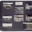
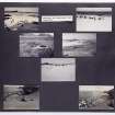
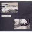
Dun Ghallain, a promontory fort formed by two lines of defence cutting off approach from the east, and having precipitous drops on the other three sides. The walls, whose plan is not now clear, have been well built of dry-stone masonry incorporating many large stones. Traces of possible huts are visible inside the fort, and great quantities of fallen debris lying all round the hill testify to the former strength of the defences.
S Piggott and C M Piggott 1948
This fort measures internally 30.0m E-W by 25.0m and is generally as described. The inner wall, which encircles the top of the promontory, has outer facing stones visible throughout the whole of its circumference. The entrance is in the NE and the interior is featureless apart from abundance of loose stone; no huts can be distinguished within the fort. The outer wall cuts off approach from both the E, where it is built on top of a natural wall of rock, and the S.
Surveyed at 1:10,000.
Visited by OS (BS) 5 April 1974
Field Visit (June 1976)
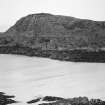
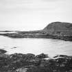
NR 348 931. This fort occupies a commanding position at the w end of a rocky promontory 1.8km W of Machrins. The summit is defended by an oval wall, enclosing an area about 30m by 20m with an outer wall on the E and s sides. The main wall is best preserved on the E and S sides, where it is about 3m thick and 0.7m high in five courses; at one point on the NE a stretch of medial face is visible a short distance S of the entrance, which faces NE. Two of the facing-stones of the NW side-wall of the passage appear to be still in position. There is a modern marker cairn (a on RCAHMS plan) on the highest point of the interior.
The outer wall runs along the crest of a rocky ridge on the E side and along the lower flanks of the summit on the SE, where long stretches of the outer face are visible; its course on the S, however, is largely masked by rubble, and on the W and N the sheer cliffs made any secondary defence unnecessary. There is a gap in the wall-debris on the NE in line with the entrance through the main wall, but a single large outer facing-stone shows that the outwork continued to the cliff-edge.
RCAHMS 1984, visited June 1976
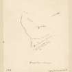
Measured Survey (1976)
RCAHMS surveyed the fort at Dùn Gallain using plane-table and alidade at a scale of 1:400. The resultant plan was redrawn in ink and published at a reduced scale (RCAHMS 1984, fig. 91A).
Note (2 October 2014 - 18 October 2016)
This fort occupies the summit of a coastal headland. Oval on plan, it measures 30m from NE to SW by 20m transversely within a wall 3m in thickness; a long stretch of the outer face is visible around the E and S, in places standing 0.7m high in five courses. A medial wall-face within the thickness of the wall on the E possibly indicates multiperiod construction. The entrance is on the NE, opening onto a terrace on the cliff-edge, which has also been utilised for the entrance through an outer wall that extend from the cliff here round the E and S to the cliffs on the W; Of slighter construction it also retains several runs of outer facing-stones.
Information from An Atlas of Hillforts of Great Britain and Ireland – 18 October 2016. Atlas of Hillforts SC2166


