
Oronsay, Druim Mor


Cairnfield (Period Unknown), Enclosure (Period Unknown), Field System (Period Unknown)
Site Name Oronsay, Druim Mor
Classification Cairnfield (Period Unknown), Enclosure (Period Unknown), Field System (Period Unknown)
Alternative Name(s) Rubha Caol
Canmore ID 377206
Site Number NR38NE 13.01
NGR NR 3505 8716
Datum OSGB36 - NGR
Permalink http://canmore.org.uk/site/377206


- Council Argyll And Bute
- Parish Colonsay And Oronsay
- Former Region Strathclyde
- Former District Argyll And Bute
- Former County Argyll
Field Visit (20 April 1974)
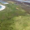
NR 351 871. Situated on the S of Oronsay on flat ground on the edge of the 25' raised beach are some fifty clearance cairns and several field banks. Most of the area is now covered by a layer of peat which is as much as 20cm thick on the clearance cairns. The cairns are composed of large sea-washed stones. An area to the SE of the system is less well cleared and supports a growth of grass and bracken. The banks measure up to 4.0m wide and 0.7m high with the cairns up to 1.2m high. There is no hut circle within this field system but 200m to the NE is a well- preserved hut.
Visited by OS (JP) 20 April 1974
Measured Survey (1978)
RCAHMS surveyed the hut-circle, field-system and cairns at Druim Mor at a scale of 1:1000. The plans, covering some 55 hectares, were redrawn in ink and published at a reduced scale (RCAHMS 1984, opp p.136).
Field Visit (April 1979)
Formerly recorded under Canmore ID 37802
See also Canmore ID 377195, 377205-377210
Situated on Druim Mor, the broad peninsula that forms the SW limb of Oronsay, there are the extensive remains of a
multiperiod field-system, several groups of cairns and a hut-circle. The various elements are described as they occur from SW to NE (see plan RCAHMS 1984, opp 136).
(3) The largest and most impressive group of remains is situated on the crest of the upper raised-storm-beach and extends for some distance on the raised beach to the NE (C). It comprises at least fifty-five cairns and stretches of banking belonging to at least two periods, and is overlain by rig-and-furrow cultivation which except for two outlying cairns has probably destroyed the northward extension of this group. The earliest features appear to be a series of stony banks, measuring between 2m and 5m in thickness and up to 0.6m in height, which form part of a field-system made up of a number of relatively small enclosures. In addition, there is a larger enclosure (D), built up against a bank which flanked the groups on the w and s with a spur extending towards (2). The interior of D is largely soil-less, being composed of raised-beach pebbles. In at least two instances cairns have been built on top of the banks, and it is therefore possible that the majority of the cairns are later than the banks. The cairns measure up to 6.5m in diameter and 0.8m in height. Later ploughing and stone-clearing has elongated some of them, and a few may be of comparatively recent date. Possibly contemporary with the rig-and-furrow cultivation is a stretch of earth-and-stone dyke which has been built on top of the earlier bank forming the E side of enclosure D. It then continues northwards along the line of the earlier flanking banks and forms part of an extensive enclosure-system.
RCAHMS 1984, visited April 1979.

