
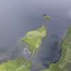
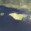
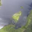
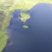
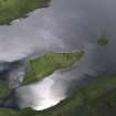
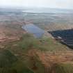
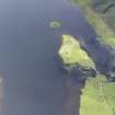
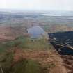
Islay, Loch Finlaggan, Eilean Na Comhairle


Building(S) (Medieval), Hall House (Medieval)(Possible), Midden (Period Unassigned), Polished Axehead (Stone)(Period Unknown), Unidentified Flint(S) (Flint)(Period Unassigned)
Site Name Islay, Loch Finlaggan, Eilean Na Comhairle
Classification Building(S) (Medieval), Hall House (Medieval)(Possible), Midden (Period Unassigned), Polished Axehead (Stone)(Period Unknown), Unidentified Flint(S) (Flint)(Period Unassigned)
Alternative Name(s) Council Island
Canmore ID 37691
Site Number NR36NE 20
NGR NR 38771 68017
Datum OSGB36 - NGR
Permalink http://canmore.org.uk/site/37691


- Council Argyll And Bute
- Parish Killarow And Kilmeny
- Former Region Strathclyde
- Former District Argyll And Bute
- Former County Argyll
NR36NE 20 3876 6801
(NR 3876 6801) Remains of buildings were noted on the circular Eilean na Comhairle, traditionally regarded as the "council" island (associated with castle NR36NE 6, on Eilean Mor). There is no evidence to suggest that Eilean n Comhairle is a crannog, nor any causeway from it to Eilean Mor. Three flint flakes were picked up on the shore, one had been artificially struck.
F Celoria 1959.
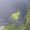
There are two building footings, turf-covered and measuring 7.5 by 5.0m and 9.0 by 5.0m on Eilean na Comhairle. The island, from the old beach level, is 2.5m high and 27.0 by 22.0m on plan; it has a regular outline and shows medium stone at base, but overall is probably too high to be considered as a crannog. Stones protude above present water level from the opposing shore of Eilean Mor, but nothing else apparent that might indicate a causeway.
Surveyed at 1:10 000.
Visited by OS (JM), 7 June 1978.
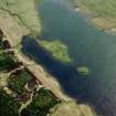
Eilean na Comhairle is circular, about 30m in diameter, and seperated from the top of Eilean Mor by a 50m-wide stretch of water, formerly crossed by a causeway. The island appears largely or totally to be of artificial construction. The RCAHMS survey traced three structures, buildings a, b and c. Trench 16 covered part of a and b and showed them to have clay-bonded stone walls. There was evidence of site clearance in in the 19th century.
Building a was a sub-rectangular building, unicameral (contrary to the RCAHMS plan), with opposed doorways in its long walls and a central hearth. It was possibly a hall with building b serving as a private chamber. Both buildings sat over the flattened remains of a large structure with lime mortar walls 1.5m thick. This is tentatively identified as the remains of a small rectangular enclosure castle. The island effectively consists of its ruins, which appear to be the result of systematic dismantling and removal of stonework.
D H Caldwell 1993.
One of the main aims of continued excavation on Eilean na Comhairle was to define further the massive lime-mortared walls found in 1993, supposed to be the remains of a medieval castle. This may have been a hall-house, on the basis of the pottery, built in the 13th century. Building (a), planned by the RCAHMS, and overlying it, may have been the meeting place for the Council of the Isles. An archaeomagnetic determination from its hearth, provided by GeoQuest Associates, suggests that it was occupied in the 15th century and not the 16th as previously supposed.
The walls of the castle were founded on rubble with numerous voids, retained around at least the S and W sides of the island by a thick drystone wall, evidently the remains of a dun or broch which forms the main mass of the island. Part of a cist or stone-lined box with deposits of cramp was viewed but not excavated. A polished stone axe was recovered nearby.
Limited work in June by The Scottish Trust for Underwater Archaeology demonstrated the presence of extensive midden deposits containing animal bone and medieval pottery on the side of the island adjacent to Eilean Mor. From the shore of the island at this point was recovered a 14th-century Roman pilgrim's badge.
D H Caldwell 1994.
NR 3878 6802 In 1994 limited reconnaissance work by the Scottish Trust for Underwater Archaeology demonstrated the presence of medieval midden deposits on the side of the island adjacent to Eilean Mor. In 1997 it was possible to sample these, thanks to the co-operation of the Army, particularly the Edinburgh OTC, in building a dam and pumping the water out from an area of about 80m2. It is estimated that the midden may spread over a total area of about 400m2. Refuse may have settled here because this side of the island is sheltered. The causeway to Eilean Mor, and possibly a jetty, may have helped to trap it.
The midden is sealed by gravel and iron pan. From the gravel have been recovered medieval artefacts, perhaps mostly eroded from the island edge. They include two short cross pennies of the first half of the 13th century.
The midden was sampled in a number of small test-pits. It had an organic, sandy, fibrous matrix, packed with considerable quantities of animal bone, hazelnut shells, and pieces of wood, including round wood, twigs and offcuts of worked timber. Sherds of pottery, leather shoes and a broken stone mortar confirm its medieval (?12th-13th century) date.
This deposit had a maximum depth of 400mm before giving on to a layer of blocks and boulders, in which were two empty post-settings. Excavation to deeper levels was limited but showed that the stones sealed another organic-rich deposit, similar to the upper one, but with noticeably greater quantities of wood, especially withies, and pieces of peat. There was no apparent structure to this but the stubs of three birch stakes were encountered in situ. This woodwork, with the overlying stone layer, probably represents the remains of an artificial platform, the date of which has still to be established. An earlier artificial platform was represented by an underlying sequence of stone layer, midden and wood-rich organic deposit, resting on the bottom of the loch.
A thorough programme of wet sieving, flotation and taking of samples for other environmental work was undertaken.
Sponsors: National Museums of Scotland, Russell Trust, Schroder Charity Trust, The Army, Society of Antiquaries of Scotland.
D H Caldwell 1997.
Measured Survey (1963 - 1976)
Between 1963 and 1976 RCAHMS produced a series of measured drawings at Castle Finlaggan, including a site plan of Eilean na Comhairle and Eilean Mor as well as detailed plans of buildings A, C and Q (the chapel) all on Eilean Mor. The pencil drawings were redrawn in ink and published at reduced scales (RCAHMS 1984, figs. 33(K), 276, 277B, 278C, 279A).
Field Visit (May 1981)
Eilean Na Comhairle ('council isle'). This island is separated from Eilean Mor by a channel measuring about 45m at its minimum width. Access between the two islands was obtained by means of a stone causeway of which considerable traces still remain at its centre and N end. In these areas, where the water is fairly shallow, the causeway can be seen to have a width of about 2m, each side being defined by large boulders. One or two of the stones protruded above water-level at the date of visit.
The channel deepens considerably at its SW end and there are now no traces of a causeway at this point; it is possible that this part of the channel was spanned by a timber bridge but no traces of a such a structure are now visible. In addition to the causeway there are the remains of two small jetties, one on the W shore of the island and the other on the E shore; both are formed of large boulders.
the centre of the island rises above the level of the loch to a height of about 2.4m, the central area being defined on its W, S and E sides by a steeply sloping bank. Although now turf-covered, it seems likley that this bank is artificail, either in whole or in part, for at several points on its circumference fragments of masonry can be seen, one of them showing traces of lime mortar in the interstices. The scanty remains of three sub-rectangular buildings (a-c) can be seen within the central area. The largest of them (a), which measures about 11m from NW to SE by 6.7m transversely over all, appears to have contained two rooms, each served by its own doorway in opposite side-walls. Monro's account identifies this island as the site of the Council-house, or place of assembly, of the Council of the Isles, but none of the existing buildings appears well-suited to that purpose. A table of stone, 'where this council sat in the Isle of Finlaggan', is said to have been 'carried away by Argyle with the bells that were in Icolumkill', probably during an expedition by the Marquess of Argyll about 1642.
RCAHMS 1984, visited May 1981

