
Pricing Change
New pricing for orders of material from this site will come into place shortly. Charges for supply of digital images, digitisation on demand, prints and licensing will be altered.
Upcoming Maintenance
Please be advised that this website will undergo scheduled maintenance on the following dates:
Thursday, 9 January: 11:00 AM - 3:00 PM
Thursday, 23 January: 11:00 AM - 3:00 PM
Thursday, 30 January: 11:00 AM - 3:00 PM
During these times, some functionality such as image purchasing may be temporarily unavailable. We apologise for any inconvenience this may cause.
Islay, Duisker


Burial Ground (Medieval), Chapel (Medieval)
Site Name Islay, Duisker
Classification Burial Ground (Medieval), Chapel (Medieval)
Alternative Name(s) Duisker 1
Canmore ID 37679
Site Number NR36NE 1
NGR NR 36627 66432
Datum OSGB36 - NGR
Permalink http://canmore.org.uk/site/37679


- Council Argyll And Bute
- Parish Killarow And Kilmeny
- Former Region Strathclyde
- Former District Argyll And Bute
- Former County Argyll
NR36NE 1 3662 6643.
(NR 3662 6643) Chapel (NR) (In ruins) Burial Ground (NR)
OS 6" map, Argyllshire, 2nd ed., (1900)
The turf-covered founds of an ancient chapel stand about 1 1/2ft in height in the centre of its burial ground. Nothing is known of the history of the site.
(The facts that the burial ground lies at the SE corner of Buaile na L Eaglaise - Fold of the Church - and that the stones of the chapel are undressed and dry-built, have been partially obliterated from the report).
Name Book 1878.
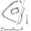
The chapel measures internally 6.5m ENE-WSW by 3.5m within a wall, 1.2m to 1.5m wide and 0.9m high, now over-grown with turf but with some facing stones exposed. The entrance was in the SSW wall. The burial ground, enclosing the chapel, is roughly triangular in shape, and measures 22.0m by 16.0m, the wall is similar in state to that of the chapel, but on the NW extent it is more substantial, being 1.2m high and 3.5m broad. In the east, the wall is incorporated in the line of a field wall. Inside the ESE angle of the burial ground are footing of a buiding.
Surveyed at 1:10 000.
Visited by OS (J M) 2 June 1978.
Field Visit (September 1975)
(NR 366 664) The footings of this chapel stand within a burial-ground about 700m SE of Duisker farmhouse and 600m ESE of the chapel NS36NE 2. The building measures about 6.5m from ENE to WSW by 3.5m transversely within what appear to have been drystone walls about 1m in thickness; the entrance is centrally placed in the ESE wall. The burial-ground is roughly triangular on plan, measuring about 22m from N to S by 23m transversely within a drystone wall about 1m in thickness; the entrance was probably situated close to the s corner.
There are no identifiable tombstones.
RCAHMS 1984, visited September 1975.
Measured Survey (September 1975)
RCAHMS surveyed the chapel and burial-ground at Duisker 1 at a scale of 1:100. The plan of the chapel was redrawn in ink and published at a reduced scale (RCAHMS 1984, fig. 26L), with a site plan including the burial-ground at a smaller scale (fig. 170C).

