|
Photographs and Off-line Digital Images |
B 36915 |
Records of the Royal Commission on the Ancient and Historical Monuments of Scotland (RCAHMS), Edinbu |
4 Survey drawings.
1) Bruichladdich, Chapel and Burial Ground, Islay. Plan. c.1975
2) Islay, Craigens, Cill Eileagain, Chapel and Burial Ground, Islay. Plan. c.1975
3) Cill Mhoire, Lagavulin, Burial ground, Islay. Plan.
4) Duisber chapel and Burial Ground, plan c.1975.
|
10/5/1976 |
Item Level |
|
|
Prints and Drawings |
AGD 973/1 |
Records of the Royal Commission on the Ancient and Historical Monuments of Scotland (RCAHMS), Edinbu |
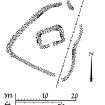
Chapel and Burial Ground, Duisker I, Islay.
Plan of site.
Titled: 'Chapel and Burial Ground, Duisker I, Islay'. |
|
Item Level |
|
|
Prints and Drawings |
AGD 973/2 |
Records of the Royal Commission on the Ancient and Historical Monuments of Scotland (RCAHMS), Edinbu |
Chapel and Burial Ground, Duisker II, Islay. |
|
Item Level |
|
|
Prints and Drawings |
DC 3419 |
Records of the Royal Commission on the Ancient and Historical Monuments of Scotland (RCAHMS), Edinbu |
4 Survey drawings of chapel site plan.
Bruichladdich Chapel; Duisker; Cill Mhoire; Craigens, Cill Eilehean. |
|
Item Level |
|
 |
On-line Digital Images |
SC 427368 |
Records of the Royal Commission on the Ancient and Historical Monuments of Scotland (RCAHMS), Edinbu |
Publication drawing. Chapel and burial-ground, Dusiker 1, Islay; plan
|
1975 |
Item Level |
|
 |
On-line Digital Images |
SC 2414219 |
Records of the Ordnance Survey, Southampton, Hampshire, England |
Islay, Duisker, NR36NE 1, Ordnance Survey index card, page number 1, Recto |
1958 |
Item Level |
|
 |
On-line Digital Images |
SC 2414220 |
Records of the Ordnance Survey, Southampton, Hampshire, England |
Islay, Duisker, NR36NE 1, Ordnance Survey index card, page number 1, Recto |
1958 |
Item Level |
|
 |
On-line Digital Images |
SC 2414221 |
Records of the Ordnance Survey, Southampton, Hampshire, England |
Islay, Duisker, NR36NE 1, Ordnance Survey index card, page number 2, Recto |
1958 |
Item Level |
|
|
All Other |
551 166/1/1 |
Records of the Ordnance Survey, Southampton, Hampshire, England |
Archaeological site card index ('495' cards) |
1947 |
Sub-Group Level |
|


