
Pricing Change
New pricing for orders of material from this site will come into place shortly. Charges for supply of digital images, digitisation on demand, prints and licensing will be altered.
Islay, Dun Athad


Fortification (Medieval) - (Post Medieval), Promontory Fort (Prehistoric)(Possible)
Site Name Islay, Dun Athad
Classification Fortification (Medieval) - (Post Medieval), Promontory Fort (Prehistoric)(Possible)
Alternative Name(s) Mull Of Oa
Canmore ID 37290
Site Number NR24SE 3
NGR NR 28470 40686
Datum OSGB36 - NGR
Permalink http://canmore.org.uk/site/37290


- Council Argyll And Bute
- Parish Kildalton And Oa
- Former Region Strathclyde
- Former District Argyll And Bute
- Former County Argyll
NR24SE 3 2849 4070
(NR 2849 4070) Dun Athad (NR)
OS 6" map (1900)
A dun on a promontory which is linked to the mainland by a natural causeway. The remains of the fortifications crowning the ascent from the causeway on the promontory side belong to at least two periods. The early part consists of a chamber, 39ft NW-SE by 19 1/2ft NE-SW, with an entrance in the NW wall opening on the narrow freeway giving access from causeway to promontory. Later the landward wall of this chamber was continued across the freeway to the cliff face (W Lamont 1959). 'Just within the fortifications are two open ports, presumably for dropping rubbish over the cliffs on either side. At the point where the Trig Station is marked on the map there is a depression which looks as though it had been surrounded by drystone'.
Information from W D Lamont letter, 2 October 1957.
A narrow promontory fort 90.0m NE-SW by 15.0m defended on the landward side by a ruined wall and elsewhere by vertical cliffs. The wall, which has intermittent outer facing-stones intact, is 20.0m long and is spread to a maximum of 6.5m. The entrance is collapsed and no longer visible. Immediately behind the wall is a level area apparently rock-cut and measuring 15.0m by 12.0m which may be the main living area of the fort. There is no trace of any structure at the site of the OS Trig.
The promontory is approached by a sunken way, lined with earthen banks, and a natural causeway 3.0m wide. The whole of the surface of the fort is under rig and furrow and it seems probable that the sunken way is associated with this later use.
Surveyed at 1:10 000.
Visited by OS (BS) 31 May 1978
Field Visit (May 1978)
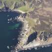
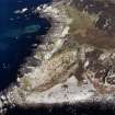
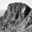
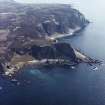
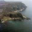
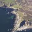
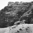
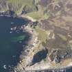
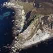
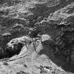
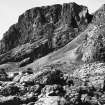
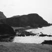
NR 284 407. These remains occupy the summit of a large and impressive coastal promontory which is situated about 2 km SE of the Mull of Oa. The position is one of considerable natural strength and commands an extensive prospect as far as the Antrim coast and the Mull of Kintyre. Rocky cliffs rise sheer on each flank of the promontory to a height of over 105m and the summit-area is an irregular linear platform measuring 90m in maximum extent from NE to SW and varying in width from 6m to 23m. The approach from the landward or NE side is across a narrow neck of land about 2m in minimum width, and thence obliquely by a sloping ascent along the W edge of the main ridge, skirting the remains of a massive forework. The forework, which measures 17.8m in length from E to W and is returned at each end, has a well-defined outer kerb of facing-stones, but is otherwise reduced to a bank of stony debris some 5.8m in maximum ascertainable thickness. The rubble core of this wall contains the remains of one (and possibly a second) small circular hut of intramural construction. It may have served as an annexe to building A which lies behind the forework. This building is of rectangular plan and measures 11m in length from E to W by 3m transversely within low turf-covered walls; the entrance is located in the W end-wall. Building or enclosure B (RCAHMS 1984 plan) is of roughly ovoid plan measuring 5m in maximum length from E to W within low scarped banks; it has an entrance in the W sector and is partly overlaid by rigs. Structures A and B lie within a relatively sheltered and hollowed interior circumscribed by traces of a dyke and upstanding rock-cut walls. The remainder of the summit is a narrow and exposed plateau which contains much evidence of rig-cultivation, and retains portions of turf dykes along the W flank and the SW boundary. A short distance down the rocky sw slope there is a level grassy platform (D) which also incorporates the remains of an outer turf bank. The oval depression at C possibly marks the site of a well or cistern for the supply of fresh water.
The approach track across the adjacent headland is flanked by turf banks, and there are traces of other field-banks and structures on the E side of the headland. On the boulder-strewn foreshore around the base of the promontory there are a number of rock-shelters and caves, some of which are fronted by enclosure-walls of boulder construction. One of the caves contains deposits of manganese ore.
The natural advantages of this site may have invited fortification from prehistoric or Early Historic times, but the existing defences and associated buildings appear to date from an otherwise unrecorded refortification of the 16th or early 17th century. It may have served as one of the beacon-stances used by the supporters of Sir James MacDonald in 1615. A slightly later topographical account refers to the 'great fortress called Dunaynt,' which with 'small expensis . . might be maid ane Invincible strength'. (Geog Coll)
RCAHMS 1984, visited May 1978.
Measured Survey (1978)
RCAHMS surveyed Dun Athad at 1:1000. The plan drawing was reproduced in ink and published at a reduced scale (RCAHMS 1984, fig. 265B).
Note (10 September 2014 - 23 May 2016)
One of the most spectacular promontory works in Scotland, Dun Athad is a narrow finger of land, which projects SW from the cliffs of the Oa and drops away almost sheer along both sides to the foreshore 105m below. The defences comprise a single thick wall 17.8m in length commanding the slope that drops into a narrow coll on the landward side; a well defined outer face can be traced, returning at either end, and though the line of the inner face is unknown the rubble core is spread about 5.8m in thickness, extending up to the rear wall of a large rectangular building set roughly E and W across the top of the promontory; in the course of a visit by the HFSG a piece of vitrified stone was identified in the wall core. The entrance was probably between the terminal of the wall and the NW margin of the promontory, where the modern path gains access to the roughly level interior on the top of the promontory. This measures about 90m from NE to SW by between 6m and 23m transversely (0.1ha), and while there are traces of structures at the NE end, it is mostly covered with cultivation rigs.
Information from An Atlas of Hillforts of Great Britain and Ireland – 23 May 2016. Atlas of Hillforts SC1877

