|
Prints and Drawings |
DC 40 |
Records of the Royal Commission on the Ancient and Historical Monuments of Scotland (RCAHMS), Edinbu |
Topographical map of islands Jura, Islay, Colonsay, Oronsay.
Inv.p.1. RCAHMS Copy in library.
(Currently missing - 31/5/96) |
|
Item Level |
|
|
Photographs and Off-line Digital Images |
DC 45 P |
Records of the Royal Commission on the Ancient and Historical Monuments of Scotland (RCAHMS), Edinbu |
Distribution map of forts, broch, duns. Inv. p.21. RCAHMS |
c. 1984 |
Item Level |
|
|
Photographs and Off-line Digital Images |
AG 10818 |
Records of the Royal Commission on the Ancient and Historical Monuments of Scotland (RCAHMS), Edinbu |
RCAHMS |
1979 |
Item Level |
|
|
Photographs and Off-line Digital Images |
AG 10819 |
Records of the Royal Commission on the Ancient and Historical Monuments of Scotland (RCAHMS), Edinbu |
RCAHMS |
1979 |
Item Level |
|
|
Photographs and Off-line Digital Images |
DC 159 P |
Records of the Royal Commission on the Ancient and Historical Monuments of Scotland (RCAHMS), Edinbu |
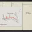
Plan ink 1:400 RCAHMS Inv no. 155 |
1975 |
Item Level |
|
|
Prints and Drawings |
DC 160 |
Records of the Royal Commission on the Ancient and Historical Monuments of Scotland (RCAHMS), Edinbu |
PTS pencil 1:400 RCAHMS |
1975 |
Item Level |
|
|
Photographs and Off-line Digital Images |
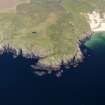
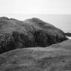
E 63507 CN |
RCAHMS Aerial Photography |
General oblique aerial view looking across the remains of the fort and Lossit Bay towards the S coast of Islay, taken from the NW. |
12/5/2005 |
Item Level |
|
|
Photographs and Off-line Digital Images |
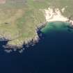
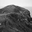
E 63508 CN |
RCAHMS Aerial Photography |
Oblique aerial view centred on the remains of the fort, taken from the SW. |
12/5/2005 |
Item Level |
|
|
Photographs and Off-line Digital Images |
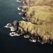
PA 246/11/1 |
Photographs by Violet Banks, professional photographer, Edinburgh, Scotland |
General view of Lossit Bay, Islay from above
|
c. 1920 |
Item Level |
|
|
Photographs and Off-line Digital Images |
PA 246/11/3 |
Photographs by Violet Banks, professional photographer, Edinburgh, Scotland |
General view of Lossit Bay, Islay
|
c. 1920 |
Item Level |
|
 |
On-line Digital Images |
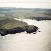
DP 112355 |
RCAHMS Aerial Photography Digital |
General oblique aerial view of fort at Dun Na Faing, Lossit Point, Islay, taken from the WSW. |
3/5/2011 |
Item Level |
|
 |
On-line Digital Images |
DP 112356 |
RCAHMS Aerial Photography Digital |
General oblique aerial view of Lossit Bay, taken from the W. |
3/5/2011 |
Item Level |
|
 |
On-line Digital Images |
SC 1723730 |
RCAHMS Aerial Photography |
General oblique aerial view looking across the remains of the fort and Lossit Bay towards the S coast of Islay, taken from the NW. |
12/5/2005 |
Item Level |
|
 |
On-line Digital Images |
SC 1723731 |
RCAHMS Aerial Photography |
Oblique aerial view centred on the remains of the fort, taken from the SW. |
12/5/2005 |
Item Level |
|
 |
On-line Digital Images |
SC 2254370 |
Records of the Royal Commission on the Ancient and Historical Monuments of Scotland (RCAHMS), Edinbu |
RCAHMS |
1979 |
Item Level |
|
 |
On-line Digital Images |
SC 2254371 |
Records of the Royal Commission on the Ancient and Historical Monuments of Scotland (RCAHMS), Edinbu |
RCAHMS |
1979 |
Item Level |
|
 |
On-line Digital Images |
SC 2413325 |
Records of the Ordnance Survey, Southampton, Hampshire, England |
Islay, Lossit Point, Dun Na Faing, NR15NE 3, Ordnance Survey index card, page number 1, Recto |
c. 1958 |
Item Level |
|
 |
On-line Digital Images |
SC 2413326 |
Records of the Ordnance Survey, Southampton, Hampshire, England |
Islay, Lossit Point, Dun Na Faing, NR15NE 3, Ordnance Survey index card, page number 2, Recto |
c. 1958 |
Item Level |
|
 |
On-line Digital Images |
SC 2413327 |
Records of the Ordnance Survey, Southampton, Hampshire, England |
Islay, Lossit Point, Dun Na Faing, NR15NE 3, Ordnance Survey index card, Recto |
c. 1958 |
Item Level |
|
 |
On-line Digital Images |
SC 2413328 |
Records of the Ordnance Survey, Southampton, Hampshire, England |
Islay, Lossit Point, Dun Na Faing, NR15NE 3, Ordnance Survey index card, Recto |
c. 1958 |
Item Level |
|
|
Prints and Drawings |
DC 45 |
Records of the Royal Commission on the Ancient and Historical Monuments of Scotland (RCAHMS), Edinbu |
Distribution map of forts, broch, duns. Inv. p.21. RCAHMS |
c. 1984 |
Item Level |
|
|
Prints and Drawings |
DC 159 |
Records of the Royal Commission on the Ancient and Historical Monuments of Scotland (RCAHMS), Edinbu |
Plan ink 1:400 RCAHMS Inv no. 155 |
1975 |
Item Level |
|
|
All Other |
551 1/4/1/22/1/73 |
Records of the Royal Commission on the Ancient and Historical Monuments of Scotland (RCAHMS), Edinbu |
Fort, Dùn na Faing, Lossit Point, Islay |
|
Batch Level |
|
|
All Other |
551 166/1/1 |
Records of the Ordnance Survey, Southampton, Hampshire, England |
Archaeological site card index ('495' cards) |
1947 |
Sub-Group Level |
|


