
Scheduled Maintenance
Please be advised that this website will undergo scheduled maintenance on the following dates: •
Tuesday 3rd December 11:00-15:00
During these times, some services may be temporarily unavailable. We apologise for any inconvenience this may cause.
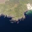
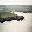
Islay, Lossit Point, Dun Na Faing


Fort (Period Unassigned)
Site Name Islay, Lossit Point, Dun Na Faing
Classification Fort (Period Unassigned)
Canmore ID 37243
Site Number NR15NE 3
NGR NR 1714 5655
Datum OSGB36 - NGR
Permalink http://canmore.org.uk/site/37243


- Council Argyll And Bute
- Parish Kilchoman
- Former Region Strathclyde
- Former District Argyll And Bute
- Former County Argyll
NR15NE 3 1714 5655
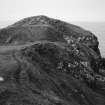
(NR 1714 5655) A fort (RCAHMS) lies at the extremity of Lossit Point. Some three to four acres are cut off by a barrier wall, 10ft wide and about 175ft long, and on the landward, ie the S, side, by a wide depression or ditch which may be largely natural. To the S a slighter wall runs parallel to the ditch and barrier. The E wall, at the entrance 8ft wide, is inturned to the N and continued to the foot of a scarp to enclose about an acre, within which, backing onto the main wall near the entrance, is a D-shaped enclosure 24ft by 36ft. Immediately to the W of the entrance, a much heavier D-shaped building 42ft across both axes, con- tains a similar outline 10ft across within a strong stone wall. To the E and W of this small cells are inset in the barrier wall.
F Newall 1964
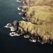
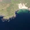
A promontory fort along the top of a steep and rocky E-W slope guards the only landward approach to Lossit Point and effectively encloses an area of nearly 2.0ha.
It comprises a contoured stone wall, 60.0m long and now tumbled to a width of 6.0m and a height of 1.0m. Several lengths of outer facing blocks survive and show the wall to have been partly built out over the slope, but no inner facing blocks were found. The stone-faced entrance gives access on its W side to the 'D shaped enclosure', an undulating tumbled mass of turf covered stone, measuring 12.0m by 10.0m, enclosed by a curving wall. This could be a stratetgically placed 'guard-house' built onto the fort wall. On the E side of the entrance and extending northwards to a steep outcrop is 2.0m wide tumbled partion wall; apparently contemporary. No habitation traces were found elsewhere on the headland.
The 'outer ditch' referred to is a natural hollow, and the parallel wall to the S, is a modern boundary.
Surveyed at 1:10 000.
Visited by OS (JRL) 23 May 1978
Field Visit (July 1975)
NR 171 565. A substantial drystone wall cuts off the promontory of Lossit Point (see inset, a in RCAHMS plan [RCAHMS 1984]) and secures an area measuring about 180m by 140m. The wall, which runs from NE to SW, is on the crest of a ridge and survives as a band of stones about 3.5m in thickness with several long stretches of outer facing-stones surviving to a height of 1.7m. The entrance is at the centre of the wall, but only the stones of the s side of the passage survive. The wall has been severely robbed to provide material for adjacent field-boundaries and buildings of comparatively recent date, and there is no trace of any continuation at its N end, where the grassy slope on this flank would not in itself have provided adequate defence. The interior is featureless and the grassy patches between the rocky outcrops have been heavily cultivated.
RCAHMS 1984, visited July 1975
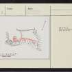
Measured Survey (1975)
RCAHMS surveyed the fort at Dùn na Faing using plane-table and alidade at a scale of 1:400. The resultant plan was redrawn in ink and published at a reduced scale (RCAHMS 1984, fig. 93A).
Note (23 September 2014 - 4 August 2016)
A large rocky promontory on the W coast of the Rhins of Islay immediately N of the mouth of Lossit Bay is cut off by a substantial drystone wall. Largely reduced to a band of rubble about 3.5m thick, with occasional inner facing-stones and several longer stretches of the outer face; which in one place still stands 1.7m high. The interior measures about 180m from NW to SE by 140m transversely (2.4ha), but a substantial part of this along the western flank is bare rock descending to the sea, leaving an area of about 1.4ha under grass amongst the outcrops. Most of this latter area has been cultivated in rigs, and the wall has also been robbed to provide material for adjacent field-banks and enclosures. The entrance is on the SE, midway along the line of the wall.
Information from An Atlas of Hillforts of Great Britain and Ireland – 04 August 2016. Atlas of Hillforts SC2062

