
Pricing Change
New pricing for orders of material from this site will come into place shortly. Charges for supply of digital images, digitisation on demand, prints and licensing will be altered.
Scheduled Maintenance Notice
Please be advised that this website will undergo scheduled maintenance starting on Thursday, 30th January at 11:00 AM and will last until Friday, 31st January at 10:00 AM.
During this time, the site and certain functions may be partially or fully unavailable. We apologise for any inconvenience this may cause.
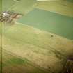
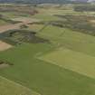
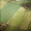
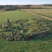
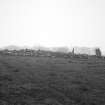
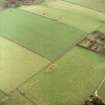
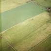
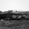
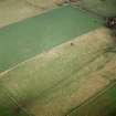
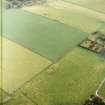
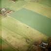
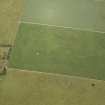
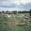
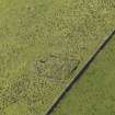
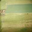
Old Bourtreebush


Cairn (Period Unassigned), Cup Marked Stone (Prehistoric), Stone Circle (Neolithic) - (Bronze Age)
Site Name Old Bourtreebush
Classification Cairn (Period Unassigned), Cup Marked Stone (Prehistoric), Stone Circle (Neolithic) - (Bronze Age)
Alternative Name(s) Old Bourtree Bush
Canmore ID 37197
Site Number NO99NW 2
NGR NO 9035 9608
Datum OSGB36 - NGR
Permalink http://canmore.org.uk/site/37197


- Council Aberdeenshire
- Parish Banchory-devenick
- Former Region Grampian
- Former District Kincardine And Deeside
- Former County Kincardineshire
Field Visit (March 1983)
NO99NW 2 9035 9608.
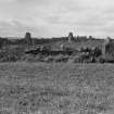
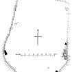
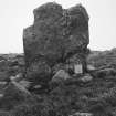
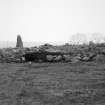
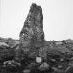
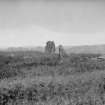
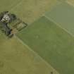
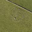
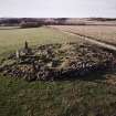
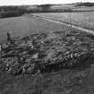
A stone circle enclosing a cairn (possibly a ring-cairn) is situated on the crest of a low rise 240m W of Old Bourtreebush farmhouse. The circle measures about 26m in diameter and has been reduced to an arc of five stones (four upright, one fallen) running from the SW round to the E, with a possible sixth stone lying embedded in the ground on the W; the status of a prostrate block on the E is unknown but it is unlikely to be a recumbent. The tallest of the upright stones (2.7m high) is on the SW and the smallest (1.2m high) is on the E; except for a rectangular slab on the S, which measures 1.8m by 0.6m at the base and 2.4m in height, all the stones are pointed. The cairn is visible as a low stony mound strewn with field-cleared stones.
RCAHMS 1984, visited March 1983.
(Statistical Account (OSA) 1792; A Thomson 1865; Name Book 1864; R A Smith 1880; F R Coles 1900; A Thom, A S Thom and A Burl 1980)
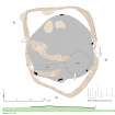
Measured Survey (12 June 2003)
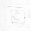
RCAHMS surveyed Old Bourtreebush stone circle on 12 June 2003 with plane table and alidade producing a plan and sections at a scale of 1:100. The plan and sections were used as the basis for an illustration, produced in ink and finished in vector graphics software, that was published at a scale of 1:250 (Welfare 2011, 536).
Field Visit (23 September 2007)
NO 9035 9608 Identified on 23 September 2007. On the southernmost upright stone of Old Bourtreebushstone, a cup mark slightly W of centre and 0.96m above ground level.
George Currie, 2007.
Publication Account (2011)
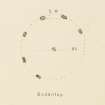
This stone circle encloses the remains of a cairn on a low rise in the field about 200m west of Old Bourtreebush. It measures about 25m in diameter and may originally have comprised as many as fifteen orthostats if the spacing of fallen and upright stones on the south-east quarter was repeated around the rest of the circumference. In all, only four of these remain upright (1, 2, 4 & 6), but three other large stones lie prone around the margin of the cairn (3, 5 & 8), while a fourth may be represented by a loose stone that is possibly a stump on the north (7). In addition, William Lukis’ plan of 1884 suggests another two fallen stones may lie hidden beneath the turf and field clearance elsewhere on the northern arc (GM 7829.38). The fallen orthostats include a long boulder (5) some 3.5m in length embedded in the cairn material on the east, which for the last 150 years has been interpreted as a recumbent (below). The heights of the upright orthostats suggest that the circle was graded, with the tallest stone standing 2.9m high on the south-west (1) and the rest reducing in height round to the stone 1.45m high on the east-north-east (6). By and large the orthostats are pointed, with the notable exception of one on the south (2), which is a much more rectangular slab, albeit with a jagged top. The cairn within the interior has been heavily disturbed by stone robbing and excavations, and its surface is also strewn with field-cleared stones and boulders. The identification of Old Bourtreebush as a recumbent stone circle has a long history rooted in James Garden’s correspondence with John Aubrey in 1692. The relevant passages are quoted in the Gazetteer entry for nearby Aquhorthies; suffice it to say here that it is not possible to distinguish Aquhorthies from Old Bourtreebush in Garden’s description and that at one point he implies that only one had a recumbent, even though he subsequently revised this to both. As he perceived them, one comprised two circles of stones and the other three, which at least throws some light on the shattered cairn within the interior of Old Bourtreebush. The concentric rings of orthostats and kerbstones surviving at Aquhorthies provide a yardstick, and kerbed cairn has been lost from the interior of Old Bourtreebush. The general spacing of the orthostats of the surrounding circle, however, leaves little scope for a recumbent setting in the southern half of the ring, and ever since Alexander Thomson excavated here in 1858, general opinion has tended to accept that the large prostrate stone on the east (5) is a recumbent. Thomson, incidentally, provides a sequence of measurements for the four upright stones, but while those for the first two roughly reconcile to orthostats 1 and 2, the rest are way adrift (1864, 134). Nevertheless, bar the addition of some more field clearance, little seems to have changed here since Thomson’s day. The first OS surveyors show the same stones in 1865 (Name Book, Kincardineshire, No. 2, p 110; Kincardineshire 1868, viii), and some 20 years later in 1884 Lukis produced a metrically accurate plan and elevations of the stones that are instantly recognisable and infinitely superior to Coles’ efforts in 1899 (Lukis 1885, 307–8; Coles 1900, 141–4, figs 2–4). Therefore, we can be confident that the stone now tentatively identified on the north of the ring as a stump (7) is not one of the two on the north that Lukis annotates down & buried out of sight (GM 7829.38). Lukis also shows the stone at the centre that Thomson mentions, though when the excavation party turned it in 1858 they found nothing underneath. Ironically this stone is the sole feature of the circle that Christian Maclagan managed to get right on her patently unreliable sketch plan (1875, 73, pl xxvii). For reasons best known to herself, she annotated this Bodentoy, showing six evenly spaced stones around the west, south and east, and reconstructing the position of a recumbent between the two on the south-west. In this last respect she may have been of one mind with Lukis, who partly on the strength of Garden’s letters also believed that a recumbent had been removed (1885, 308). Old Bourtreebush seems to have been the first circle that Coles recorded in his great survey and he did not have the weight of experience that he was to accumulate over the next few years. Had he surveyed it rather later he might have been more critical than his description implies: ‘The long stone on the south E point is doubtless the Recumbent Stone, so striking a feature in many of these circles’ (ibid 143). There is an expectation in his description that is also eloquently captured in the composition of a photograph of this fallen stone taken by James Ritchie in October 1904 (RCAHMS KC294). Unfortunately Coles' identification has exerted a persistent influence and Old Bourtreebush is routinely listed as a recumbent stone circle (eg Burl 1976a, 360, Knc 13, 360; Barnatt 1989, 295–6, no. 6:72; Ruggles 1999, 188, no. 85), despite the note of caution that Burl has introduced in some of his other works (Thom et al 1980, 229; Burl 1995, 140; 2000, 429, Knc 16). The present survey has taken an altogether more critical stance. Garden is not a reliable source for the presence of a recumbent setting here (contra Barnatt 1989, 295–6), and the position of the stone on the east does not conform to that of any other surviving recumbent; nor does it have any evidence of flankers to complete a setting. Other types of stone circles enclosing cairns are sufficiently numerous that there is no imperative that there should have been a recumbent setting here. With the southern focus that occurs in so many of these monuments, it is the contrast between the rectangular slab (2) set up on the south and the pointed pillars elsewhere that is perhaps the salient point of significance.
Visited 12 June 2003

