Pricing Change
New pricing for orders of material from this site will come into place shortly. Charges for supply of digital images, digitisation on demand, prints and licensing will be altered.
Upcoming Maintenance
Please be advised that this website will undergo scheduled maintenance on the following dates:
Thursday, 9 January: 11:00 AM - 3:00 PM
Thursday, 23 January: 11:00 AM - 3:00 PM
Thursday, 30 January: 11:00 AM - 3:00 PM
During these times, some functionality such as image purchasing may be temporarily unavailable. We apologise for any inconvenience this may cause.
Campstone Hill, Raedykes
Ring Cairn (Neolithic) - (Bronze Age)
Site Name Campstone Hill, Raedykes
Classification Ring Cairn (Neolithic) - (Bronze Age)
Alternative Name(s) Raedykes South-east; Raedykes 1
Canmore ID 37185
Site Number NO89SW 9
NGR NO 83301 90600
Datum OSGB36 - NGR
Permalink http://canmore.org.uk/site/37185
- Council Aberdeenshire
- Parish Fetteresso
- Former Region Grampian
- Former District Kincardine And Deeside
- Former County Kincardineshire
NO89SW 9 83301 90600
See also NO89SW 6, NO89SW 7, NO89SW 8.
This ring-cairn is situated on the crest of Campstone Hill 280m NW of Raedykes farmhouse. It measures 3.9m in diameter within a band of cairn material at least 5.5m thick and 0.4m high; the inner kerb appears to have been rebuilt, probably following partial excavation in 1964-5. Set in a straight line on the SSW there are three large kerbstones (measuring up to 1.1m in length by 0.6m in height) but, although three other possible kerbstones extend round to the W and there are several others on the N and E, the perimeter of the cairn cannot be identified with certainty. Surrounding the ring-cairn there is a stone circle measuring 17m in diameter, the nine surviving stones range from 0.7m to 1m in height.
Name Book 1864; J Ritchie 1923; A S Henshall 1963; A Thom, A S Thom and A Burl 1980; A Small 1965; RCAHMS 1984, visited April 1984.
Visible on air photographs AAS/93/07/G17/9-14. Copies held by Grampian Regional Council.
Information from M Greig, Grampian Regional Council, March 1994.
Field Visit (2 May 1957)
There is another cairn SE of No. 1 (i.e. the largest of the "circles " marked on the OS map) which has been of the same type but is even more disturbed. Stones A-H presumably represent the remains of an outer ring of independent stones while J -L, which are laid on edge, may have taken the place of the recumbent stone. All these stones however have been linked by dry walling to make a stell, while a smaller stell (M) has been formed in the interior. The cairn and peristalith have been removed, but the central chamber i s represented by a hollow with three stones on the perimeter. The chamber has no doubt been plundered.
Visited by RCAHMS 2 May 1957 (sketch plan in MS)
Field Visit (April 1984)
NO89SW 9 8330 9060
This ring-cairn is situated on the crest of Campstone Hill 280m NW of West Raedykes farmhouse. It measures 3.9m in diameter within a band of cairn material at least 5.5m thick and 0.4m high; the inner kerb appears to have been rebuilt, probably following partial excavation in 1964-5. Set in straight line on the SSW there are three outer kerbstones (the largest measuring 1.1 m in length by 0.6m in height) and although there are three possible kerbstones farther to the W with several others on the N and E, the perimeter of the cairn cannot be identified with certainty. Surrounding the ring-cairn there is a stone circle measuring 17m in diameter; the nine surviving stones range from 0.7m to 1m in height.
RCAHMS 1984, visited April 1984.
(Name Book 1864; J Ritchie 1923; A S Henshall 1963; A Thom, A S Thom and A Burl 1980; A Small 1965)
Publication Account (1996)
Strung along the crest of Campstone Hill at c 190m 00, this important group of early ritual sites has open views to the east. The first feature, 280m north-west of West Raedykes, is a fine ring cairn, 9.4m in diameter and 0.4m high, with the kerbed open central area, 3.9m in diameter, clearly visible. Nine stones up to 1m high survive in the surrounding stone circle, 17m in diameter. 20m to the west-north-west is an oval cairn, 8.5m by 7.7m nd 0.5m high, which is either a ring cairn or a robbed round cairn. The third site, 15m further to the west-north-west, is very similar. The fourth feature stands higher than the others and 80m north-west of the first; it comprises another ring cairn, 10.2m in diameter and 0.6m high, within a stone circle 13.9m in diameter, of which five of the possible 13 stones remain. A close relationship with the recumbent stone circle tradition can be seen on the south-south-west arc of the cairn, where two tall stones are set close together (the western is 1.7m and the eastern is 1.1m tall) with the stump of another in between. Other pillar stones protrude at intervals from the kerb. This emphasis on the south-west was echoed in the surrounding stone circle. (The Roman temporary camp, no. 68, may be visited from here.)
Information from ‘Exploring Scotland’s Heritage: Aberdeen and North-East Scotland’, (1996).
Field Visit (14 April 2005)
A group of at least two ring-cairns, and possibly as many as four, is strung out over a distance of some 100m on the summit of Campstone Hill. Two of them have formal kerbs and are surrounded by stone circles (see also NO89SW 6), but the other two are little more than featureless ring-banks measuring about 8m in overall diameter (NO89SW 7-8). By and large, the cairns command an open aspect, which on the SE extends to the coast around Stonehaven, but the view from the ring-cairn at the SE end of the group is restricted by the rising ground to the NW, and is hidden from the summit. All lie in rough grazing, now partly colonised by gorse, amidst extensive remains of field-banks and clearance cairns.
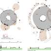
This ring-cairn (NO89SW 9), the southern of the two surrounded by a stone circle, lies at the SE end of the group, but is set on slightly lower ground than the others, and has been badly damaged by stone robbing and the construction of a later enclosure, possibly a sheepfold, on its E side. The cairn is slightly oval on plan, and measures 15m from NNW to SSE by 13.5m transversely, though the line of its perimeter is difficult to determine. Nevertheless, a row of seven kerbstones survives on the SSW, and single kerbstones can be identified on the NNW, NNE, ENE, SSE and ESE. The row on the SSW includes three forming a straight line, which are more impressive than the rest, measuring between 0.8m and 1.07m in length, 0.21m and 0.43m in thickness and 0.51m and 0.64m in height. The internal court measures 4m in diameter, though only the kerbstones on the S appear to be in situ. Those demarcating the N side of the court appear to be modern walling, perhaps reconstituted after the excavation of 1965 (DES 1965, 24), and they do not appear in Henshall’s published account (1963a, Fig.105, 401).
The stone circle surrounding the cairn measures about 18.5m in diameter and may originally have comprised at least sixteen stones. Of those that now remain, all are grey in colour save for three that are pink granite. Where best preserved on the N, the stones are set between 2.2m and 2.6m apart, and range in height from 0.5m to 1.09m, though they do not appear to be graded regularly in height. Thirteen are in situ, two of them now reduced to stumps, and six are displaced, with a further two possible stones missing on the SE. On the NE, three of the stones are accommodated within the outer wall of the sheepfold, and the lower courses of a later wall can be seen linking those from the NE to the SW. This wall may continue on the SSE as a short stretch of grass-grown stony bank, joining the circle to another field-bank. The circle does not appear to be concentric with the outer kerb of cairn, and the two appear to converge on the NNE. A lot of loose stone lies scattered outside the circle on the SSW, and a small upright block of pink granite situated 12.5m to the WSW lies amongst a small heap of field-clearance.
Visited by RCAHMS (ARG) 14 April 2005
Measured Survey (15 April 2005)
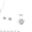
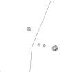
RCAHMS surveyed the Campstone Hill, Raedykes ring cairns on 15 April 2005 with plane table and self-reducing alidade producing a site at a scale of 1:500. The survey drawing was later used as the basis for an illustration produced in ink and finished in vector graphics software at a scale of 1:1000.
Measured Survey (14 April 2005)
RCAHMS surveyed the Campstone Hill, Raedykes ring cairn (NO89SW 9) on 14 April 2005 with plane table and alidade producing a plan and section a scale of 1:100. The plan and section were used as the basis for an illustration, produced in ink and finished in vector graphics software, that was published at a scale of 1:250 (Welfare 2011, fig. 7.16).


