Accessibility

Font Size

100% 150% 200%

Background Colour

Default Contrast
Close Reset

Drumtroddan 4

Cup And Ring Marked Rock (Neolithic) - (Bronze Age)

Site Name Drumtroddan 4

Classification Cup And Ring Marked Rock (Neolithic) - (Bronze Age)

Canmore ID 368492

Site Number NX34SE 146

NGR NX 36278 44722

Datum OSGB36 - NGR

Permalink http://canmore.org.uk/site/368492

Ordnance Survey licence number AC0000807262. All rights reserved.
Canmore Disclaimer. © Bluesky International Limited 2025. Public Sector Viewing Terms

Toggle Aerial | View on large map

Digital Images

Digital photograph of panel to south, from Scotland’s Rock Art Project, Drumtroddan 4, Dumfries and Galloway
Digital photograph of panel to south, from Scotland’s Rock Art Project, Drumtroddan 4, Dumfries and GallowayDigital photograph of close ups of motifs, from Scotland’s Rock Art Project, Drumtroddan 4, Dumfries and GallowayScanned image of rock art location sketch, Scotland's Rock Art Project, Drumtroddan 1-4, Dumfries and GallowayScanned image of rock art location sketch, from Scotland’s Rock Art Project, Drumtroddan 4, Dumfries and GallowayDigital photograph of rock art panel context, Scotland's Rock Art Project, Drumtroddan 4, Dumfries and GallowayDigital photograph of panel to north, from Scotland’s Rock Art Project, Drumtroddan 4, Dumfries and GallowayDigital photograph of panel in context without scale, from Scotland’s Rock Art Project, Drumtroddan 4, Dumfries and GallowayDigital photograph of perpendicular to carved surface(s), from Scotland’s Rock Art Project, Drumtroddan 4, Dumfries and GallowayDigital photograph of panel in context with scale, from Scotland’s Rock Art Project, Drumtroddan 4, Dumfries and GallowayDigital photograph of rock art panel context, Scotland's Rock Art Project, Drumtroddan 4, Dumfries and GallowayDigital photograph of panel to west, from Scotland’s Rock Art Project, Drumtroddan 4, Dumfries and GallowaySnapshot of 3D model, from Scotland’s Rock Art Project, Drumtroddan 4, Dumfries and GallowayDigital photograph of rock art panel context, Scotland's Rock Art Project, Drumtroddan 4, Dumfries and GallowayDigital photograph of rock art panel context, Scotland's Rock Art Project, Drumtroddan 4, Dumfries and GallowayDigital photograph of panel to south-east, from Scotland’s Rock Art Project, Drumtroddan 4, Dumfries and GallowayScanned image of rock art panel sketch, Scotland's Rock Art Project, Drumtroddan, general location sketch with site numbers, Dumfries and GallowayScanned image of rock art panel sketch, from Scotland’s Rock Art Project, Drumtroddan 4, Dumfries and GallowayScanned image of rock art location sketch, from Scotland’s Rock Art Project, Drumtroddan 1, 2, 3 and 4, Dumfries and GallowaySnapshot of 3D model, from Scotland’s Rock Art Project, Drumtroddan 4, Dumfries and GallowayDigital photograph of rock art panel context, Scotland's Rock Art Project, Drumtroddan 4, Dumfries and GallowayDigital photograph of rock art panel context, Scotland's Rock Art Project, Drumtroddan 4, Dumfries and GallowayDigital photograph of panel to north-east, from Scotland’s Rock Art Project, Drumtroddan 4, Dumfries and Galloway

Administrative Areas

  • Council Dumfries And Galloway
  • Parish Mochrum
  • Former Region Dumfries And Galloway
  • Former District Wigtown
  • Former County Wigtownshire

Activities

Note (29 April 2019)

Date Fieldwork Started: 29/04/2019

Compiled by: ScRAP Team

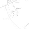
Location Notes: Drumtroddan 4 is part of a group of cup-and-ring marked rocks (Drumtroddan 1 - 4) located within a fenced-off area in a field approximately 200m S of Drumtroddan Farm. Further rock art panels are located within a similarly fenced-off enclosure approximately 20m to the NW (Drumtroddan 8-13), and within a wooded area approximately 70m to the W (Drumtroddan 5-7). Drumtroddan 1 - 4 are part of the same Canmore ID (62794) and HER record (MDG2466) and, together with the panels in the other fenced-off enclosure and within the wooded area, are included within the same scheduled monument designation (SM90101), and are properties in care.

The two enclosures lies at the highest point of the field, and are part of a larger outcrop ridge. There are views in all directions, and particularly to the N, E and W, with the Galloway Hills visible in the distance to the NE. The enclosure within which Drumtroddan 4 is located contains four panels, Drumtroddan 1 - 4. Drumtroddan 4 lies in the W part of the enclosure, approximately 3m to the W of the most northerly of the panels, Drumtroddan 1.

Panel Notes: Drumtroddan 4 is a rectangular-shaped panel with a pointed W end. It measures 1.3 x 0.6m and rises to 0.2m at its highest point. The panel displays numerous fissures across its surface, and a large natural hollow.

The panel has been carved with three (or possibly four) cup-and-ring motifs. In the centre towards the SW end there is a cup with three rings. To the W of this there is a cup with two partial rings, and at the W end a cup with one partial ring. The possible cup and one partial ring with a tail is located on the N side, in the middle part of the panel.

References

MyCanmore Image Contributions


Contribute an Image

MyCanmore Text Contributions