
North Ronaldsay, Broch Of Burrian


Broch (Iron Age), Settlement (Pictish)
Site Name North Ronaldsay, Broch Of Burrian
Classification Broch (Iron Age), Settlement (Pictish)
Alternative Name(s) Burrian Broch; Strom Ness; Stromness; Burrian Brough
Canmore ID 3679
Site Number HY75SE 3
NGR HY 76274 51380
Datum OSGB36 - NGR
Permalink http://canmore.org.uk/site/3679


- Council Orkney Islands
- Parish Cross And Burness
- Former Region Orkney Islands Area
- Former District Orkney
- Former County Orkney
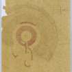
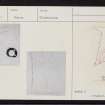
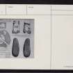
Burrian, Broch of Burrian 1, North Ronaldsay, cross-slab
Measurements: H 0.75m, W 0.38m tapering to 0.28m, D 0.05m
Stone type: clay slate
Place of discovery: HY 7627 5138
Present location: National Museums Scotland, Edinburgh (GB.1)
Evidence for discovery: found in a secondary level within the broch during excavations in 1870.
Present condition: the surface has suffered from flaking, and some of the carving of the cross has been lost.
Description
This tapering slab bears a very lightly incised cross and ogham inscription on one broad face. The cross is carved towards the right-hand side of the slab as if to allow space for the inscription. The cross has an equal-armed head with four expanded rectangular terminals and wide circular armpits. The shaft is weathered and incomplete. The inscription is ‘the only extant sentence in Pictish’, recording the making of the cross (Forsyth 1996, 202).
Date: seventh or eighth century.
References: Traill 1890; MacGregor 1974, no 279, 96; Forsyth 1996, 187-205; Fisher 2002, 49, 52; Scott & Ritchie 2014, no 15.
Compiled by A Ritchie 2016.
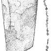
Burrian, Broch of Burrian 2, North Ronaldsay, carved pebble
Measurements: L 150mm, W 58mm
Stone type: sandstone
Place of discovery: HY 7627 5138
Present location: National Museums Scotland, Edinburgh (GB.9)
Evidence for discovery: found in a secondary level within the broch during excavations in 1870.
Present condition: the surface has suffered from flaking and wear.
Description
This oval pebble has two flattish faces and both are carved. On one side there is a pecked and smoothed pentacle containing small circles and curved lines, while on the other side there is an incised hexagram, both of approximately the same size.
Date: sixth to eighth centuries.
References: Traill 1890; MacGregor 1974, no 278, 96.
Compiled by A Ritchie 2017
HY75SE 3.00 7627 5138
(HY 7627 5138) Burrian Brough (NR).
OS 6" map, Orkney, 2nd ed.,(1900).
HY75SE 3.01 HY 7627 5138 Incised pebble; incised bone
HY75SE 3.02 HY 7627 5138 Cross-slab: ogam-inscribed
See also HY75SE 2 and HY75SE 19.
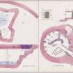
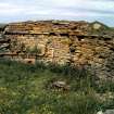
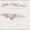
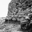
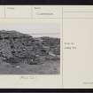
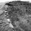
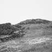
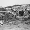
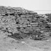
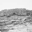
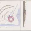
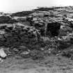
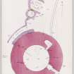
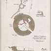
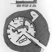
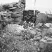
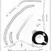
A broch, excavated by Dr Wm Traill in 1870 (and described in The Orkney Herald in October 1870) showed two phases of occupation, and possibly a third - Celtic ecclesiastical. The wall is 15' thick, enclosing a courtyard 32' in diameter, with an entrance in the SE and a mural cell in the NE arc. A peculiarity of the construction is a 4' high 'intake' above a scarcement 3' above the original occupation floor. It is defended by the remains of four ramparts on the landward side. In the second phase the broch was converted into a sort of wheelhouse with septal divisions. Buttressing on the outer face of the NW arc may belong to this period, as may the remains of several small buildings on the north.
The outer face of the wall is obscured, being incorporated in/a later wall on the east and SE and largely hidden by a 9'-10' high mass of debris on the north and NW. There is a well in the courtyard.
What Radford takes to be evidence of the existence of a Celtic christian community - ie, a monastery or hermitage - is provided by an early cross with an Ogham inscription, an ox-bone with Pictish symbols and a pebble with Celtic designs which he compares with the pebble-cut votive crosses of St Ninian's Cave, Whithorn (NX43NW 8). A Celtic bell of the earlier type (5th - 9th c) was also found and 3 bone dice. (D V Clarke 1970).
Dr Traill donated the finds from the site to the National Museum of Antiquities of Scotland (NMAS) in 1872.
Proc Soc Antiq Scot 1875 (Donations); J R Allen and J Anderson 1903; RCAHMS 1946, visited 1928; C A R Radford 1962; R W Feachem 1963; C Thomas 1963; A MacGregor 1975.
Burrian broch as described and planned. A perforated bronze needle 3 1/2" long was found in the field to the W centred HY 762 514, and is now in the possession of Mr J Seatter of Howar, North Ronaldsay.
Surveyed at 1/2500.
Visited by OS (NKB) 22 July 1970.
RMS GB 230: Fragment. Intact side numbered 6 with four of the dots enclosed by two concentric circles. The damaged sides both have two dots, on one side enclosed by single circles and on the other by two concentric circles.41 x 21mm.
RMS GB 231: Numbered 3, 4, 5, 6: the '3' and '4' sides damaged. All dots enclosed by poorly executed single circles. 44 x 17mm. Bad restoration of this broken piece has caused the anomalous cross-section. RMS GB 229: No markings are certainly discernible on the worn and damaged surfaces. 43 x 16mm. Find spot unknown.
D V Clarke 1970. E J MacKie 1971.
Historic Scotland, delisted 20 March 2000.
(Undated) information from Historic Scotland.
Scheduled as Burrian, broch and settlement.
Information from Historic Scotland, scheduling document dated 3 March 2000.
'The Saturday Herald and Shetland Gazette' in 1871 briefly mentions that an Oghan stone from the site had been donated to the S A S Museum.
M Howe 2006
Excavation; geophysical survey HY 7627 5138 Slumped deposits were cleared and excavated in September 2005 over a section at the Broch of Burrian (HY75SE3) during dyke repairs. Truncated undisturbed archaeological deposits of ash and a pit or gully were revealed, but there was no need to excavate them. Most of the material cleared by the work
was derived from a spoil heap from William Traill's excavations of 1870-71. Finds from this material include three bone pins and a Pictish painted quartz pebble. Orkney College Geophysics Unit conducted a gradiometer survey over c 1ha around the site. The results indicated differences in construction between the broch ramparts, identified the remains of structures outwith the ramparts, and located other anomalies of archaeological significance often corresponding with extant earthworks, some of which continued beyond the Scheduled area. Anomalies relating to the medieval/
post-medieval site of Burrigar farmstead were also located.
Reports to be lodged with Orkney SMR and NMRS.
Sponsor: HS.
P Sharman 2005.
Iron Age comb; stone spindle whorl HY 763 514 Fragment of bone or antler weaving comb and a stone spindle whorl found eroding from a wall adjacent to the Broch of Burrian. The comb, which has lost most of its handle, retains nine teeth. The biconical whorl is 29.1mm in diameter. Claimed as Treasure Trove (TT.15/05) and allocated to NMS, where they join similar objects from the 1870-71 excavations at Broch of Burrian.
A Heald 2005.
Historic Scotland - delisted 20.3.2000.
Note (1980)
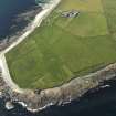
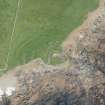
Burrian, North Ronaldsay HY 7627 5138 HY75SE 3
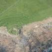
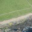
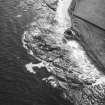
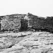
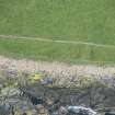
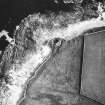
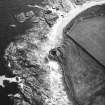
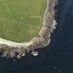
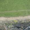
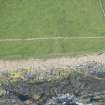
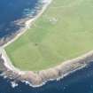
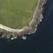
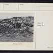
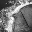
Very impressive broch and outbuildings within multivallate earthworks which constitute a promontory fort. Site is of special historical interest for Pictish and Early Christian associations. Sea erosion vigorous and imminently devastating; broch wall stands on wavecut platform and is undercut by 0.4m for half of circumference, threatening collapse very soon.
RCAHMS 1980
(Traill 1890; plans in NMRS; Anderson 1881, 173-5; RCAHMS 1946, ii, pp. 45-7, No. 193; p. 51, No. 201; Stevenson 1955; Radford 1962; MacGregor 1974; OR 217)
Publication Account (1996)
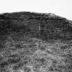
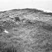
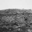
The seaward side of the broch has suffered inevitable erosion, compounded by the fact that it has been incorporated into the island's sheep dyke, the wall that keeps the seaweed-eating sheep on the foreshore. But the broch is still an impressive monument, its wall more than 3m high, and traces on the landward side of four concentric ramparts. There appear not to have been guard-cells flanking the passage leading into the broch, only a small cell opening from the interior at ground level. Oddly, the ledge on which the first floor would have been supported is at a height of only 1m above the floor, and about 1.3m above the ledge the wall is stepped inwards, both features difficult to explain in terms of how the interior of the broch was arranged. There is also an underground well or storage chamber.
Excavations in the early 1870s were of a better standard than was often the case, and they produced a large collection of artefacts, spanning iron-age and Pictish times, as well as bones of cattle, sheep, pig, dog and horse. There was clearly re-use of the site in the 7th and 8th centuries AD, not only within the broch but also in domestic structures outside.
Information from ‘Exploring Scotland’s Heritage: Orkney’, (1996).
Field Visit (1999)
This broch, which was excavated in the 19th C, lies on the coast edge and is eroding. It is located on a small headland, separated from the hinterland by a series of defensive earthworks, forming a promontory fort of sorts. A large number of artefacts, including an extensive assemblage of worked bone objects, were recovered during excavation. In addition, a number of artefacts of early historic or Pictish date were found. These include a cross-slab with ogham inscription, painted pebbles and part of an iron bell of Celtic type. Part of a Pictish house was uncovered to the north east side of the broch and there are topographical indications that further structural remains may survive in the surrounding area. The site is very badly undermined by coastal erosion and is vulnerable to largescale collapse. A number of small exposures containing archaeological deposits occur along the seaward side and there are numerous rabbit scrapes in the broch interior and surroundings. Ref.: Traill, W (1880) 'Results of excavations at the broch of Burrian, North Ronaldsay, Orkney, 1870-1871', Arch Scotica 5, 2, 1880, 341-64 ;RCAHMS (1946), #201; MacGregor, A (1975) 'The Broch of Burrian, North Ronaldsay, Orkney', PSAS 105, 1972-4, 63-118; RCAHMS (1980), #68; Hedges, JW (1987) 'Bu, Gurness and the brochs of Orkney, Part 3', BAR, Brit series 165, 105-8.
Moore & Wilson 1999.
Coastal Zone Assessment Survey, 1999
Publication Account (2002)
HY75 1 BURRIAN 5
HY/76275138
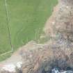
A probable solid-based broch on North Ronaldsay (Cross and Burness parish) which stands next to the rocky shore.
The name evidently comes from the Norse Borg-in, “the fortress”. It was thoroughly excavated (by digging down into the top of the mound) by Dr. William Traill, proprietor of the island, in 1870 and 1871 after the sea had exposed part of a circular wall in the large, turf-covered mound. The wall footing is still visible above the beach and has sustained little damage since. The site was left open but, since (in sharp contrast, for example, with Burray East – ND49 1) there is hardly any rubble inside it now, the wall heads were evidently partly re-built and turfed over.
The outer defences consist of the remains of four concentric ramparts on the landward side, the second innermost now being very short. Some earlier work was evidently done at the site but the only evidence for this consists of a few artefacts from the site which were in the Orkney Museum when it was sold off in 1862 [7, 106].
The site is particularly important because it was the first broch in which clear primary and secondary occupations were observed and described, and in which finds were specifically allocated to these phases. Thus the fundamental distinction between the middle and late stages of the Atlantic Iron Age material cultural sequence was first recognised with the aid of information from this site [9].
1. Description
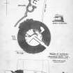
Since no door was apparent. Dr. Traill's method of excavation was to dig downwards into the centre of the mound and in this way two separate occupation levels were found inside the broch. The bottom level was a paved floor -- presumably the original one -- with "various rude implements" on it and covered by 30-60 cm (1-2 ft.) of rubbish. The second was an upper layer of paving on top of this rubbish, covering only part of the interior, and with partition walls, made of stone slabs on edge, resting on this.
From a distance the site still has the appearance of a green mound, being situated at the edge of a field and just above the shore. The grassy floor of the cleared interior is still almost completely free of debris. Because the south part of the wall is occasionally reached by high tides, some of the underlying soil has been washed away, and it can be seen that the outer face of the broch is built on top of a slightly projecting plinth of heavy stone slabs laid flat; these in turn rest on a thin subsoil of reddish earth close to the rock.
When excavated the wall was standing about 3.66 m (12 ft.) high and there were no intra-mural features apparent in it except for a cell at 3 o'clock. No guard cell was found in the entrance passage which was 4.58 m (15 ft.) long, 0.99 m (3 ft. 3 in.) wide at the outer end and 1.42 m (4 ft. 8 in.) at the inner end. Recessed checks for a door, faced with slabs on edge, were about 2.44 m (8 ft.) from the outer end (measured from the plan [4, pl. xlv]). The outer end of this passage is now immediately above the beach and blocked by modern masonry. A slab of masonry has been added against the passage wall behind the left check, making the left side into a continuous straight face; this is shown on Dryden’s plan. This wall continues into the interior for a short distance, where it rests against the first of the two radial slabs which continue the left side into the interior. Two similar slabs form an extension of the right side.
A deep well or cellar was found in the lower floor. It was covered with flagstones when discovered, was about 1.8 m (6 ft.) deep with rock-cut steps down into it but contained no water. The opening to this underground chamber was overrun by a massive secondary wall, presumably on top of the upper paving, so the later occupants seem either to have been unaware of its existence or not to have needed it. Another secondary wall, still visible, runs along and against the broch wall from about 2-5 o'clock [5, fig. 89] and conceals the entrance to the mural cell. This cell had a corbelled roof when found, though this collapsed before the end of the operation. It is probable that there was a void above the door to this cell [6, 65].
It is difficult now to be sure about which structural features belonged to the upper and which to the lower floor levels. Hedges’ recent discussion reviews the evidence from the various published plans and manuscript sketches and concludes that the radial stone slabs were probably set into the lower floor while the built walls rested on the upper [7, 107]; however no specific evidence is cited for this interpretation of the slabs (see ‘Discussion’ below). Likewise, as noted already, the deep well belongs to the first occupation. Moreover the rectangular cist, covered with a stone slab, was clearly described as being in the upper floor and this contained red ash and a pebble engraved with a Pictish symbol [Ibid.].
A scarcement projects from the inner wall face, at a height of 90 cm (3 ft.) above the floor according to the Commission but about 1.5 m (5 ft.) above the primary floor measuring from Dryden's section [4, pl. XLV]. At 1.28 m (4 ft. 2 in.) above this ledge the wall face projects forward suddenly for 10 cm (4 in.), in the form of an upside down ledge scarcement; thereafter it rises vertically again. A stone tank half full of red ashes was sunk into the upper floor.
An external "buttress" was found on the NNW consisting of masonry laid against the outer face of the broch. The Commission noted that this structure appeared to be unintelligible without excavation but observed "some of the stones being set on end and some edgeways . " From the plan of Traill and Dryden this "buttress" seems to be almost as high as the broch wall head [4, pl. XLV: 6, fig. 2]. The floor of the passage in the outbuildings which runs past the “buttress” is only a few feet below it and is still about 2.44 m (8 ft.) above the primary broch floor (though it is not clear if this passage was fully excavated).
Outbuildings exist on the landward side next to the broch and these were partly excavated by Traill. Bone pins and combs (presumably composite) were found in them, and Traill thought them coeval with the second occupation of the broch.
Finds: a fairly complete list of finds is given by Traill [4] who describes various objects as coming from the lower floor level -- the “first occupation”. These include the long-handled combs (one of which was found on the floor of the mural cell, blocked by the secondary wall), 2 bone hammerheads, 3 bone awls, 20 stone whorls, 2 stone mortars, many stone pot-lids, and pieces of 3 querns (rotary?). It is not clear how many of these objects were actually stratified on the lower floor; with the exception of the long combs their provenances are rarely given.
Reportedly belonging to the second occupation were, among other things, single and double-edged composite bone combs, 3 bone dice, 26 bone pins with ornamental heads, a stone with an 8th century Ogham inscription, (near the surface), and an ox phalange with incised "mirror case" symbol of the Pictish artistic traditions.
The excavation of the broch of Burrian is noteworthy as the first in which some sort of stratigraphical observations were made and in which artefacts of well known types were assigned to separate phases (Stevenson 1955).
A complete list of the finds, based on the collection donated by Dr Traill to the National Museum [2], has been compiled by Macgregor [6], who provides the first systematic analysis of what is known about their contexts, rightly pointing out that a number of assumptions about the material culture of the two separate occupations have been made in the past. However he omits to mention that a similar stratigraphical separation of what we would now call middle and late Iron Age material was observed in the Outer Hebrides in the 1950s (NF74 3) [8].
2. Discussion
2.1 The “reverse scarcement"
The one really unusual structural feature which can be seen at Burrian is the “reverse scarcement” about 1.30 m above the scarcement proper, and which runs along the sector opposite the entrance for a short distance. This is not mentioned in the original report, and Macgregor suggests that it had something to do with the internal timber structure of the broch [6, 65]. However the extreme rarity of this feature makes it more likely that this is a modern reconstruction carried out by the excavators. The fact that hardly any rubble has fallen from the wall into the interior -- in sharp contrast for example to the situation at Burray East (ND49 1) -- strongly implies that Dr Traill (more conscientious than James Farrer MP) had the newly exposed wall heads turfed over; since the wall head is now level he might also have added fresh masonry in places to even it off. An exactly similar “reverse scarcement” is to be seen at the Howe of Hoxa (ND49 4), explored more than twenty years earlier. The upper parts of the wall there were rebuilt and pointed with cement and part of the added wall face overhangs the lower courses in the same way.
1. The intra-mural gallery
The excavators did not specifically report any sign of an intra-mural gallery on the wall head but this could well be the result of inexperience (there is apparently a suggestion of one on an unpublished plan [7, 107]). The one at Burray East, explored a few years earlier, was only found by accident after the stair had been cleared (ND49 1). Neither was an intra-mural stairway discovered, though this is harder to explain since the wall was 3.6 m high when exposed, and there is no known raised stair door in any other broch with a sill as high as that.
It is possible that the cell at 3 o'clock -- blocked off by the secondary wall -- was in fact the stair-foot guard cell, and that the stairway rose to the right from it and was not uncovered. In the absence of any precise knowledge of what the excavator did and what he saw this certainly cannot be ruled out; it is easy to miss structural features in the ruins of the brochs of Orkney and Caithness, the sandstone material of which weathers to soil and becomes turfed over.
One long ago excavated broch in the north mainland (NC96 3) has its stairway blocked off with a wall at its foot, which leaves the stair door entering what now looks like a simple cell. On the other hand it is not impossible that Burrian 1 was a relatively low-walled dun, without an intra-mural stair, like others which have been identified; yet a class example of such ‘imitatuions brochs’ is at Howe and there is an intra-mural stair there (HY21 6). Unfortunately without further excavation we cannot know for sure. That the ruins were still impressive, and not just a mound, in the 9th century when the Norsemen arrived is suggested by their modern name, an anglicised version of the Norse borg-in, “the fortress”.
2. Stratigraphy
Concerning the stratigraphy of the interior, the description does not make it clear whether the "rubbish" on the lower floor is occupation debris or material fallen from the broch walls: if it was the latter it would imply that the tower was falling into ruin before the second occupation took place. Traill "came upon very distinct evidence of at least two separate occupations of the buildings with apparently a long interval of time between them" [4, 341] and this wording suggests that debris from the dilapidation of the broch had accumulated inside it before the second floor was laid. The construction of the external "buttressing" appears to have been casual in nature [5], suggesting that it was in fact debris from the demolition of the upper walls of the broch which had been stacked against the foot of the tower in this manner.
This phenomenon has been noted at Jarlshof and at several sites in Orkney (Midhowe and Gurness), and suggests that the start of the secondary occupation was marked by the substantial demolition of a tower-like structure.
The radial slabs which were still standing when the interior was cleared would be explained best as features set into the second floor (perhaps after an interval of abandonment and dilapidation, which led to the demolition), and which divided the outer part of the central court into compartments (Illus. 5.140). They should be approximately analogous to the wheelhouses with built radial piers which were erected inside some Shetland brochs (e.g. HU41 2). The main reason for thinking this is the assumption made by the author that the primary floor of most if not all brochs supported a wooden roundhouse with a raised floor resting on the scarcement, and that the demolition of this wooden structure often marked the beginning of a secondary phase of occupation, though still within the middle Iron Age period. The probability of this happening in the Gurness and Midhowe brochs is discussed detail ((MacKie 1995a)
However this secondary occupation went on for a long time. There were clear Pictish elements among the finds, which should belong to a period several centuries later, and the late Iron Age artefacts like the bone pins and composite combs belong to a similar period -- from about the 7th to the 9th centuries AD, that is until the Norse occupation of the Orkney islands started [4, 101 ff]. As noted a stone with a Pictish symbol was in a stone chest set into the upper floor, so this secondary floor was evidently in use for several centuries (unless there was a long period of abandonment between the first and second occupations). Further excavations among the outbuildings might clarify this point.
The Early Christian items (the iron bell and the cross-slab) were not related to any specific structures, and there is no other evidence yet that there was a monastic settlement on the site. Here again the excavation of the outbuildings might prove informative.
2.4 Finds [6: 7, 108: 9]
The majority of the finds are not attributable to a particular phase of occupation. Hedges’ system (based on MacGregor’s analysis – [6]) is followed here whereby those which can be allocated to the first occupation are labelled ‘B’ and those to the second are labelled ‘PB’. It is important to note that the label ‘PB’ does not necessarily mean that the type of artefact concerned is found only in late Iron Age contexts; some examples of the latter, known to the author, which have been found in strata of the preceding period are indicated with an asterisk [8, fig. 6].
Of the stone finds attention should be drawn to the fragment of the pointed end (with characteristic wear striations) of a bar-shaped ard share [6, fig. 19, 267]. Such implements are usually attributed to Neolithic and Bronze Age times and, if this is not an ancient curio collected by the inhabitants of the broch, it clearly implies that even in the middle Iron Age some fields on broch estates were still being ploughed with ards with stone shares. This idea is supported by the extreme rarity of iron ard shares (known only from A Cheardach Beag wheelhouse in South Uist [NF74 4] and Leckie broch in Stirlingshire [NS69 3]) and by the occasional clear evidence that the inhabitants of some brochs were still making use of stone tools, for example at Clickhimin in Shetland (HU44 1). This supports the view that the communities throughout Atlantic Scotland who adopted brochs were very variable in their technology and their economic practices.
Iron: an ecclesiastical bell of Celtic Church type, knife blades (PB), arrow head (PB), spear or dart head (PB), ferrules (PB), hatchet (PB), rings (PB), sheet iron, rivets or nail heads, blade fragments and indeterminate fragments.
Bronze: bronze pins, two with decorative terminals (PB), possible brooch fragments,
Bone: perforated mounts, some with pegs: long-handled combs (B) (including some rare examples with short teeth which look much more suitable for beating down the weft [6, fig. 13, nos. 176-83]); 1 single edged, non-composite comb; single-edged composite combs (PB); double-edged composite combs (PB); socketed antler handle; socketed cylindrical handles; bodkins (PB); needles * with a circular section and a perforation at one end (PB): pins with hardly modified heads (PB); pins with squared-off terminals; pins with decorative heads and occasional hipped shanks (PB); globular pin heads (these are for iron pins and are now well known from middle Iron Age contexts {Leckie broch} although 47 years ago the dating evidence available to Stevenson made it seem that they were more typical of the late Iron Age, though he did mention two earlier ones [9, 292-3 and fig. A, no. 27]); a point made from an ulnar bone; the end of an antler tine; a similar tine, not singled out by Hedges, which is almost certainly a bridle cheek piece [6, fig. 10, no. 144); rubbing and polishing implements made from ovicaprid metapodials; calendering implements; quern handles (presumably these are two pieces illustrated by MacGregor, though they are rather thin [6, fig. 9, nos. 125 and 126]) – see the comparable examples from Gurness (7, fig. 2.34); spindle whorls, parallelopiped dice (PB) (these are also now known from middle Iron Age contexts, as at Dun Mor Vaul; playing pieces; pommels for iron swords and daggers; ox phalanges with incised Pictish symbols; a socketed ox phalanx; weaving tablets; ‘blubber’ mattocks; a supposed linch pin, an implement grooved at one end and various pieces of worked bone and antler.
Stone: spindle whorls, cross slab carved with an Ogham inscription and a possible Pictish fish symbol [6, fig. 21], pebble with a Pictish pattern incised on it [6, fig. 20, 278] (PB), painted pebbles, fragment of a steatite vessel (PB), whetstones made of unshaped fragments, querns, mortars, grinders and pounders, pot lids, ard share, part perforated ball, pebble strike-a –lights, pumice fragments (some perforated), a steatite object and a perforated sinker. A stone whorl from the site was obtained by J W Cursiter (Hunterian Museum: B.1914.742).
Pottery: several native potsherds were found, some decorated [6, fig. 22]. They are all of globular and bucket-shaped vessels with either very slightly out-turned rims or plain urn rims. The Everted Rim style appears to be absent and only one piece shows incised decoration, below a row of bosses immediately under the short rim.
Dimensions. External diameter c. 60 ft. (18.3 m), internal diameter 30 ft. 9 ins (9.40 m): walls proportion c. 51%. In 1985 the author planned the shape of the central court with a theodolite and found that it is laid out close ton a true circle with a radius of 4.69 +/- 0.07 m; the court diameter is thus 9.38 m (30.75 ft.).
Sources: 1. OS card HY 75 SE 3: 2. Proc Soc Antiq Scot 8 (1872-74) 5-23 (finds): 3. Anderson 1883, 245-57; 4. Traill 1890: 5. RCAHMS 1946, 2, 45-7, no. 193, figs. 88-9 (structure) and 90-1 (finds): 6. MacGregor 1974: 7. Hedges et al. 1987, 105-08 and pls. 3.13 and 3.14 (ms detailed plan of broch and adjacent buildings, and overall plan with elevation, by Dryden): 8. MacKie 1965: 9. Stevenson 1955: 10. Anderson 1872, 560; 11. NMAS 1892, 231-3; 12. Allen 1903, 24-6: Lamb 1980, 16.
Other passing references to the site, with ms sources, are listed [7, 108].
E W MacKie 2002
Note (26 February 2015 - 1 November 2016)
The broch that stands on the Point of Burrian, which is the southernmost tip of North Ronaldsay, occupies all that is left of a low promontory of rock enclosed on the landward side by a series of walls or ramparts. The greater part of the promontory, however, is now swept bare by the sea, and but for the maintenance of the sheep dyke acting as a seawall round the seaward side the broch would have been destroyed long since. The broch, which was excavated by Dr William Traill 1870-1 (1880), measures some 9.4m in diameter within a wall up to 4.5m in thickness at the checked entrance on the SE; it also displays several other architectural features, including a scarcement, a mural cell and a well. The outer defences comprise up to four roughly concentric walls or ramparts drawn in a shallow arc across the landward approach from the NW. All have been severely reduced, but geophysical survey by Orkney College in 2005 suggests differences in their construction and also revealed elements of an extensive extramural settlement (Sharman 2005). The surviving area of the interior measures about 40m from NE to SW immediately to the rear of these defences by a maximum of 30m transversely (0.07ha), though it may once have extended considerably further on the seaward side. The location is not typical of promontory forts and the relationship between the broch and the outer defences is not known, but there is no reason why this was not the site of a free-standing promontory enclosure prior to the construction of the broch.
Information from An Atlas of Hillforts of Great Britain and Ireland – 01 November 2016. Atlas of Hillforts SC2849

