
Following the launch of trove.scot in February 2025 we are now planning the retiral of some of our webservices. Canmore will be switched off on 24th June 2025. Information about the closure can be found on the HES website: Retiral of HES web services | Historic Environment Scotland
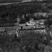
Crathes Castle


Country House (16th Century), Pavilion (Period Unassigned), Tower House (Medieval), Well (Period Unassigned)(Possible)
Site Name Crathes Castle
Classification Country House (16th Century), Pavilion (Period Unassigned), Tower House (Medieval), Well (Period Unassigned)(Possible)
Alternative Name(s) Crathes Castle Policies
Canmore ID 36693
Site Number NO79NW 8
NGR NO 73413 96801
Datum OSGB36 - NGR
Permalink http://canmore.org.uk/site/36693


First 100 images shown. See the Collections panel (below) for a link to all digital images.
- Council Aberdeenshire
- Parish Banchory-ternan
- Former Region Grampian
- Former District Kincardine And Deeside
- Former County Kincardineshire
NO79NW 8.00 73413 96801
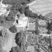
NO79NW 8.01 NO 73478 96784 Crathes Castle, Garden
NO79NW 8.02 NO 73483 96643 Crathes Castle, Doocot
NO79NW 8.03 NO 74263 96344 Crathes Castle, East Lodge Bridge
NO79NW 8.04 NO 7420 9632 Crathes Castle, East Lodge
NO79NW 8.05 NO 7325 9729 Crathes Castle, Sawmill
NO79NW 8.06 NO 7329 9727 Crathes Castle, Keeper's Cottage
NO79NW 8.07 NO 7308 9648 Crathes Castle, House of Crathes
NO79NW 8.08 NO 7321 9643 Crathes Castle, Woodbine Cottage
NO79NW 8.09 NO 7342 9648 Crathes Castle, Burial-ground
NO79NW 8.10 NO 7222 9657 Crathes Castle, West Lodge
NO79NW 8.11 NO 7315 9702 to NO 7334 9702 Crathes Estate, Lade and Ice-pond
NO79NW 8.12 NO 7335 9692 Crathes Castle, Farmsteading
NO79NW 8.13 NO 7413 9674 to NO 7424 9639 Crathes Estate, Pond, Dams and Sluices
NO79NW 8.14 NO 7414 9634 and NO 7416 9633 Crathes Estate, Ice-houses (possible)
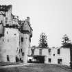
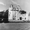
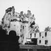
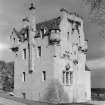
Crathes is an L-plan tower house bearing the dates 1553, 1554, and 1596.
D MacGibbon and T Ross, 1887-92.
Listed.
Scottish Castle Survey 1988; N Bogdan and I B D Bryce 1991.
The removal of a false floor in a recess on the first floor of Crathes Castle revealed a blocked staircase leading down to the kitchen area. Debris had built up at the bottom of the stairs, against the masonry blocking. This material was excavated by hand and was all coarse sieved, leading to the recovery of a small but varied assemblage of material provisionally dated to the beginning of the 19th century. The material is of special value it relates very specifically to the use of the castle which is now open to the public.
Sponsor: NTS.
R Turner 1994.
An assessment was carried out during November 1995 on the implications of raising stone flags in the 'well' room, which is thought by some to have contained the castle well. The work was necessitated by the regular welling up of water through the floor.
A slabs in the SW-quadrant of the room was lifted and a small 0.5m diameter area was exposed to the level of the previous floor. The slabs were found to overlay a surface of very hard sandy mortar-like material (layer 2) some 50mm thick, which possibly represents the floor surface prior to the present levels, or it may have been introduced as bedding for the stone slabs (layer 1). This surface (layer 2), was overlain by a 0.5mm layer of black sooty material containing flecks of whitewash (layer 3), possibly representing accumulated rubbish. Of these deposits, layers 2 and 3 are potentially of archaeological interest, but there was no evidence of their date. As the area is not under threat, further excavation was not proceeded with, and a layer of polythene is to be laid on top of layer 2, and the flags re-laid in concrete.
R Turner 1995.
(Location cited as NO 7341 9680: nominated as Site of Regional Significance). This tower-house is situated on a gentle slope at an altitude of 76m OD.
Built of granite with rounded angles, it rises to four storeys and an attic; it was built as an L-plan tower-house in the mid-16th century, a projecting wing being added later. The lower storeys are plain but above the first-floor level there is a profusion of ornament (corbelling, string-course, angle- and stair-turrets, heraldic decoration, gargoyles and gabling) which is unique to Scottish castellated architecture. The interior is famed for its plasterwork and magnificent wooden painted ceilings.
The castle bears the dates 1553, 1554 and 1596. It was built for the Burnetts of Leys who received the charter for the land from Robert the Bruce in 1323. Within the castle is held a jewelled ivory horn, the Horn of Leys, which is said to have been presented to Alexander Burnett by the Bruce when he received the charter. The Bell family are generally thought to have remodelled the upper parts of the castle. George Bell died in 1575 and I and David Bell were at work in the early 17th century. The castle came into the hands of the National Trust for Scotland in 1951.
[Air photographic imagery and newspaper references listed].
NMRS, MS/712/35.
NO 734 968 A blocked pistol loop was discovered during redecorating works in the S stair tower of Crathes Castle, between the fourth and fifth floors. The feature appears to be integral to the original fabric of the building; its typology fits well with the mid-16th-century construction of this part of the castle. Its field of fire is an arc of approximately 45o, covering the SW corner of the castle.
The internal aperture is rectangular, c 0.95m high by 0.5m wide, narrowing to an external aperture c 0.15m square, blocked with a terracotta brick or tile. The faces of the pistol loop retain much of their original plaster; layers of limewash are likely to be of some antiquity, if not primary coats. Fragments of light green window glass, similar to that found as secondary glazing in other loops in the castle, were found lying on the internal sill.
At some point in the past the pistol loop had been covered with a wooden plank and plastered over, as a redundant and possibly inconvenient feature.
Archaeological recording of the feature was carried out by Addyman & Kay.
Sponsor: National Trust for Scotland.
S M Fraser 2001a
NO 736 968 A watching brief was carried out in March 2005 during topsoil stripping in preparation for a new overflow car park as the site is within 200m of the Warren Field pit alignment and c400m from the Warren Field Neolithic hall. A small number of highly truncated negative features, possibly post-holes, were revealed near the top of a SE-facing slope. Six of these features contained flint or pottery of probable later prehistoric date.
Report to be lodged with Aberdeenshire SMR and NMRS.
Sponsor: NTS.
NO 733 969 An excavation was undertaken between February and August 2005 alongside the N and E ranges of the enclosed courtyard behind the horse mill. Later, a series of watching briefs and small-scale excavations took place in the central area and NW part of the courtyard. These interventions were aimed to record any features revealed during the lowering of the yard surface and building development work associated with the Skytrek project.
The W end of the early 19th-century N range had been demolished c 1945. This was excavated and recorded. A drain led from within the range into the yard, and three stone-lined sockets were excavated which may have held the hind posts of trevises for horse or possibly cattle stalls.
Beneath the modern yard surface was a very fine band of cobbling, c 3m wide, alongside the N and E ranges. A small area of this cobbling was also revealed beside the NE corner of the W range. The cobbling was bordered on the side facing the centre of the yard by an elegantly curved kerb of large stones. This line is shown on the 1864 OS map and can probably be dated to c 1850-64 when the horse mill was constructed. An earlier yard surface, probably early 19th century, was also identified beside the E range. Stone-lined drains were found associated with both phases of yard development.
In the E part of the central area of the courtyard, foundations were recorded which can probably be identified as the support for the saw bench used in the sawmill built during WW2. The shed of the sawmill is shown in this position in an RAF aerial photograph taken in May 1945.
Report to be lodged with Aberdeenshire SMR and NMRS.
Sponsor: NTS.
NO 734 968
A watching brief was carried out in September 2005 during the laying of a cable between Crathes Castle and Crathes
Castle courtyard and stables. To the N side of the restored Queen Anne wing of the castle, wall foundations were revealed which belonged to the 19th-century extension of the wing which had burnt in 1966. Cobbling was exposed to the E of the horse mill. This was a continuation of cobbling recorded in a separate excavation within the courtyard (see below).
See also: North Hirn Steading (NMRS Drawings: KCD/51)
NMRS REFERENCE:
Crathes castle.
Late 16th Century. Small castle unspoilt. Fine ceilings and furniture.
Architect: Walker and Duncan - estate work.
Owner - Sir James Burnett of Leys. National Trust for Scotland (from 1951).
Plans:
NMRS. Measured and drawn by Fenton Wyness, 1932.
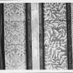
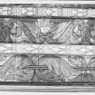
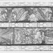
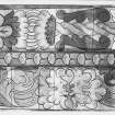
Carved stone panels. Measured and drawn by J. Scott Lawson - 1 sheet elevation.
Ancient monuments, M.O.B.P&W drawings of thesis - 3 sheets by Dr. M. Apted.
Plans:
NMRS. F.A.M. MacDonald Collection. Walker and Duncan - 1 sheet block plan of house and lay-out of garden.
- 1 sheet elevation of railing and gate to burial ground.
Druccam Farm (NMRS Drawings: KCD/25)
Harestone Steading (NMRS Drawings: KCD/40)
Hattonburn Steading (NMRS Drawings: KCD/41)
Quiddies Mill (NMRS Drawings: KCD/55)
REFERENCE:
Three late 19th century photographs in the Inigo Thomas album, purchased by NMR, Swindon in 1997.
NMRS PLANS
I G Lindsay Collection: W/219
Schomberg Scott Plans:
- Queen Anne Wing rebuilt after the fire
- 'The House of Crathes' - separate house built in the grounds for family occupation
- Staff house adjoining restaurant and stables
NMRS PRINTROOM
W Schomberg Scott Photograph Collection Acc No. 1997/39
- Photograph of drawing (another copy in photograph album)
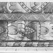
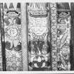
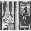
- Photograph and drawing of square carved panel
NMRS PHOTOGRAPHS
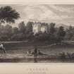
Photographic copy of sketched view, insc: 'Crathes 1837'.
Pencil and watercolour.
5 1/2" x 9"
From a sketchbook of which E Lamont had another framed sheet.
Copied while at E Lamont, Candlemaker Row 1994. Subsequently purchased by the National Trust for Scotland whose permission it is to reproduce.
- print missing at time of upgrade (12.3.1999)
EXTERNAL REFERENCE
National Library: Country Life Jan 23rd 1948 & Mar 11th 1939 - photograph and article
Non-Guardianship Sites Plan Collection, DC23247- DC23250.
Photographic Survey (1956)
Photographic survey by the Scottish National Buildings Record in 1956.
Photographic Survey (1960)
Photographic survey by the Scottish National Buildings Record/Ministry of Work in 1960.
Publication Account (1986)
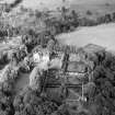
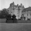
The great L-plan tower-house of Crathes is an excellent example of the changes in fortune which certain families achieved during the 16th century through the appropriation of church lands. The Bumett family had been in the Banchory area since the early 14th century, as hereditary keepers of the Forest of Drum, living in a thoroughly medieval style on the dank crannog or lake dwelling at Leys (north-east ofBanchory). The marriage arranged in 1543 between Janet Hamilton, daughter of Canon Hamilton of the abbey of Arbroath, and Alexander Bumett produced a sizeable dowry of church lands which enabled work to begin on a stylish new tower at Crathes.
The work, which took intermittently from 1553 to 1596, was carried out by one of the great Bell family of masons. Each wall face is different, the creamy pink harling rising to a deep corbel-table and a display of turrets, cannon spouts, gablets and chimneys. The south front is perhaps the least satisfactory, bearing as it does a large tliple window to the great hall inserted in the 1870s and a rather fussy clock, placed on a screen wall between two chimneys. Entry is now by the restored Queen Anne wing, beside the original entrance which still preserves its yett.
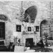
The vaulted ground floor has kitchens, store and small prison. The high hall on the fIrst floor is an imposing vaulted space with three stone bosses carved with Hamilton cinquefoils and Bumett holly leaves crowning the vault, while the famous Horn of the Leys, traditionally presented by Bruce in 1323, hangs over the fireplace.
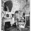
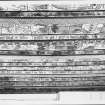
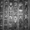
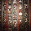
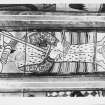
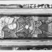
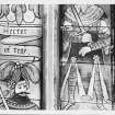
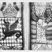
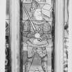
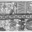
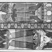
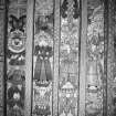
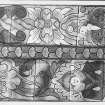
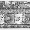
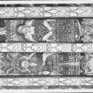
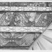
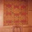
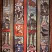
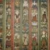
Above the hall are four rooms of particular interest Three retain their original late 16th century painted ceilings which, with wall hangings and the dim light given by cruisie lamps and the shuttered and leaded windows, create a true 16th century ambiance. In the Nine Nobles' Room (1599), heroes of the past (Hector, Caesar, Alexander, King David, Joshua, Judas,Maccabeus, King Arthur, Charlemagne and Godfrey de Bouillon, the crusader) are painted in colourfuL even fanciful versions-an all-blue Julius Caesar with broadsword and mitre-in the narrow spaces between the beams of the ceiling. The Green Lady's Room has grotesques and mottoes to add to its legendary ghost, while in the Muses' Room the colours, essentially green, are particularly sombre yet vibrant.
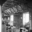
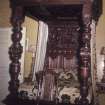
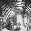
Some excellent furniture characteristic of the late 16th century Aberdeen school of woodworking can also be seen, including two fine chairs in the Nine Nobles' Room and a massive four-poster bed of1594 in the Laird's Bedroom. The wooden ceiling of the spacious Long Gallery at the top of the house is also an important piece of carpentry.
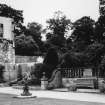
Finally, the eight gardens, set within yew hedges that go back to the early 18th century, are of exceptional appeal.
Information from ‘Exploring Scotland’s Heritage: Grampian’, (1986).
Publication Account (1996)
The great L-pl an tower-house of Crathes is an excellent example of the changes in fortune which certain families achieved during the 16th century through the appropriation of church lands. The Burnett family had been in the Banchory area since the early 14th century, as hereditary keepers of the Forest of Drum, living in a thoroughly medieval style on the dank crannog or lake dwelling at Leys (north-east of Banchory). The marriage arranged in 1543 between Janet Hamilton, daughter of Canon Hamilton of the abbey of Arbroath, and Alexander Burnett produced a sizeable dowry of church lands which enabled work to begin on a stylish new tower at Cradles.
The work, which took intermittently from 1553 to 1596, was carried out by one of the great Bell family of masons. Each wall face is different, the creamy pink harling rising to a deep corbel-table and a display of turrets, cannon spouts, gablets and chimneys. The south front is perhaps the least satisfactory, bearing as it does a large triple window to the great hall inserted in the 1870s and a rather fussy clock, placed on a screen wall between two chimneys. Entry is now by the restored Queen Anne wing, beside the original entrance which still preserves its yett.
The vaulted ground floor has kitchens, store and small prison. The high hall on the first floor is an imposing vaulted space with three stone bosses carved with Hamilton cinquefoils and Burnett holly leaves crowning the vault, while the famous Horn of the Leys, traditionally presented by Bruce in 1323, hangs over the fireplace.
Above the hall are four rooms of particular interest. Three retain their original late 16th century painted ceilings which, with wall hangings and the dim light given by cruisie lamps and the shuttered and leaded windows, create a true 16th-century ambiance. In the Nine Nobles' Room (1599), heroes of the past (Hector, Caesar, Alexander, King David, Joshua, Judas Maccabeus, King Arthur, Charlemagne and Godfrey de Bouillon, the crusader) are painted in colourful, even fanciful versions-an all-blue Julius Caesar with broadsword and mitre-in the narrow spaces between the beams of the ceiling. The Green Lady's Room has grotesques and mottoes to add to its legendary ghost, while in the Muses' Room the colours, essentially green, are particularly sombre yet vibrant.
Some excellent furniture characteristic of the late 16th century Aberdeen school of woodworking can also be seen, including two fine chairs in the Nine Nobles' Room and a massive four-poster bed of 1594 in the Laird's bedroom. The wooden ceiling of the spacious Long Gallery at the top of the house is also an important piece of carpentry.
Finally, the eight gardens, set within yew hedges that go back to the early 18th century, are of exceptional appeal.
Information from ‘Exploring Scotland’s Heritage: Aberdeen and North-East Scotland’, (1996).
Field Visit (April 1997 - April 1997)
B1/B2 Crathes Castle and reconstructed Queen Anne Wing Listed Cat. A
(19thC prints Ap.9.2-6; photographs Ap.13.5, 13.61 and others)
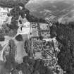
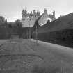
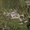
The massive 16th century tower is essentially square in plan with a short projection to the east. Connected to the latter is a two-storey wing added by the 3rd Baronet in the early-18thC, which became known as the Queen Anne Wing. In the second half of the 19thC additions were also made to this wing (the Victorian wing). Both these extensions were destroyed by fire in 1966. Only the Queen Anne section was reconstructed, in 1970-72.
The original tower house comprises four storeys and an attic, built in rough granite with rounded angles, and subsequently harled. The walls slope in 75mm as they rise from 1500mm thick at the base to the slated roofs. As at Castle Fraser and Craigievar Castle the construction of Crathes is believed to have been the work of the Bell family of masons. The lower storeys are plain. Above the first floor, the elevations flourish into corbelling, string-courses, angle- and stair-turrets, heraldic decoration, cannon gargoyles and gabling to create an impressive skyline which epitomises Scottish castellated architecture and the tower houses of the late-16th and early-17th centuries.
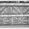
Other external features of note are the squared and gabled turrets, which alternate with circular angular turrets at roof level, and the squared-off stair tower on the south wall terminating in a crenellated look-out platform. This tower has a clock, added in the 19thC. Also in the south wall is the large triple window of the Great Hall, enlarged in the mid- to late-19thC, above which are located three stone panels with coats of arms.
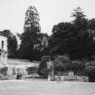
An unidentified building to the north of the castle is shown on the 1838 Estate plan and 1864 1:2,500 OS map. A low building in this position in visible on one of the late-19thC photographs of the upper garden behind a monkey puzzle tree (Ap.9/25).
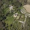
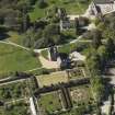
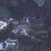
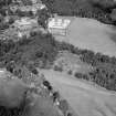
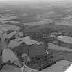
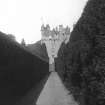
The Castle forms the focus of the landscape composition in all periods, as demonstrated by the historic maps and plans. This is most notable in the formal layout shown in Roy’s map of c.1750, but even then the enclosures on the east side of the Castle prevent extensions of vistas to the east. Pictures such as the anonymous early-19th century painting and Neale’s view (Ap.9.1 and 4), as well as the maps, demonstrate the dominance of the castle in an informal landscape, impressive from a distance as much as from within the policies (Ap.13.1 and 2). In the informal landscape of the later-18th and 19th centuries, the walled garden limits the opportunities of the composition, but creates opportunities in the relationship of the garden design to the castle, resulting in several classic views such as that across the croquet lawn to the castle and that along the yew alley to the castle, which are depicted in several old prints and drawings and in many photographs.
The Castle is well conserved under the quinquennial survey scheme, as approved by Historic Scotland. Only superficial comments on the condition of other buildings are possible within the limitations of this landscape survey.
(CRT97 B1/B2)
Information from NTS (BNMMB) January 2015
Watching Brief (20 February 2012)
NO 73372 96826 A watching brief was undertaken on 20 February 2012 during the excavation of a replacement soakaway pit to the S of the stables buildings. There were no finds or features of archaeological significance.
Archive: RCAHMS (intended). Report: Aberdeenshire Council SMR
and NTS
Funder: The National Trust for Scotland
HK Murray – Murray Archaeological Services Ltd (DES)
Project (11 November 2012 - 16 November 2012)
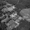
NO 73413 96801 The National Trust for Scotland's Castle Environs Project aims to gain a better understanding of the potential survival of historic garden features and potential structural features to help inform future management plans.
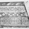
A resistance survey was undertaken, 11–16 November 2012, on the lawns to the N, S and W of the castle with the aim of mapping surviving remains of the inner court and ranges and other possible structures and garden features. Resistance survey was also carried out on the croquet lawn which lies in the walled gardens to the E of the castle. A ground penetrating radar (GPR) survey was undertaken to map possible structures adjacent to the castle in the tarmac/gravel areas that were not suitable for resistance survey.
The resistance surveys detected numerous anomalies across the three survey areas. Within the main lawn to the S of the castle, anomalies indicative of possible structural remains were identified which may relate to earlier pavilions, or similar garden features, referred to in documentary evidence. These appear to be associated with a postulated earlier walled garden in the N half of the main lawn and possible further structural remains in the S half. However, responses from modern features, such as avenues of trees, services and possible earlier drives/paths, introduce a degree of complexity to the data. Survey of the croquet lawn detected a geometric pattern of anomalies indicative of a formal garden, including paths and possible parterres. The data from the GPR surveys are dominated by responses from modern services and foundations of a Victorian wing of the castle.
Archive: Rose Geophysical Consultants
Funder: The National Trust for Scotland
Susan Ovenden, Rose Geophysical Consultants, 2013
(Source: DES)
Earth Resistance Survey (2012)
Resistance survey was undertaken on the lawns to the north, south and west of the Castle with the aim of mapping any surviving remains of the inner court and ranges and other possible structures and garden features. Resistance survey was also carried out on the Croquet Lawn which lies within the walled garden to the east of the Castle.
The resistance surveys have detected numerous anomalies across the three survey areas. Within the main lawn to the south of the Castle anomalies indicative of possible structural remains have been identified which may relate to earlier pavilions or similar garden features, referred to in documentary evidence. These appear to be associated with a postulated earlier walled garden in the northern half of the main lawn and possible further structural remains in the southern half. However, responses from modern features such as existing, and earlier, avenues of trees, services and possible earlier drives/paths introduce a degree of complexity to the data resulting in some caution in interpretation. Survey of the croquet lawn has detected an array of geomatic anomalies indicative of a formal garden layout including possible parterres.
Information from NTS (SCS) March 2014
Ground Penetrating Radar (2012)
GPR survey was undertaken to map possible structures adjacent to the Castle in the tarmac/gravel areas that are not suitable for resistance survey. A small number of radar transects were also collected within the Well Room of the Castle with the aim of confirming whether a well does indeed exist within the room.
The data from the GPR surveys are dominated by responses from modern services and foundations of a former Victorian wing of the Castle. Survey within the well room has proved inconclusive with no suggestions of a well.
Information from NTS (SCS) March 2014
Watching Brief (24 July 2013)
NO 7341 9680 The watching brief on drainage works around the base of the mid-16th-century tower of Crathes Castle was undertaken on 24 July 2013, in the context of a 1798 estate map, which shows a range extending W from the SW corner of the tower. A short section of wall and associated cobbling was revealed and recorded, but it was of very light construction and did not appear to be a convincing structural wall of the W range. It may have been a kerb to a path at this point, possibly associated with the W range or maybe much later.
Archive: RCAHMS (intended). Report: Aberdeenshire Council HER
Funder: The National Trust for Scotland
HK Murray, Murray Archaeological Services Ltd, 2013
(Source: DES)
Excavation (29 September 2014 - 27 October 2014)
NO 7341 9680 An excavation with local schools and community involvement was undertaken, 29 September – 27 October 2014, to target a number of anomalies revealed in a geophysical survey undertaken in 2013 by Rose Geophysical Consultants on the S lawn at Crathes Castle. This revealed part of a previously unknown courtyard which would have formed the approach from the River Dee to the S towards the late 16th-century castle.
Part of the W wall of the courtyard was excavated, this ties in with the geophysics so we are quite confident this extended N towards the tower. Within the W side of the courtyard there were considerable remains of a stone walled building, 3.7m wide internally and in the region of 6–7m long. It had an entrance in the E side with a stone threshold. Just to the S of the entrance there was a lime-mortared internal wall dividing the interior into two rooms. There were traces of white plaster on the inner faces of the walls. The original floor of cobbles set in thick blue clay survived in the N room, but much of the interior of the S room had been dug away by a later stonecovered soak-away. Several pieces of dressed stone were in the
demolition debris (three having rolled mouldings), so possibly the building looked quite impressive. Stone pathways outside the building extended across the courtyard. A number of smaller trenches indicated the probability that this building was mirrored on the E side of the courtyard, the two buildings flanking the access road from the S. The whole courtyard
appears to have been dismantled in the later 18th century, as an estate map of 1798 shows the area to have been landscaped to the lawn it is today.
At the S end of the lawn, although there were no surviving features, it was exciting to have found a handful of flints, emphasising yet again the importance of these ridges beside the River Dee throughout early prehistory.
Archive: The National Trust for Scotland (intended). Report and photographs: Aberdeenshire SMR and the National Trust for Scotland
Funder: The National Trust for Scotland
HK Murray and JC Murray – Murray Archaeological Services Ltd
(Source: DES)
Watching Brief (24 February 2015 - 17 March 2015)
NO 73410 96800 A watching brief was carried out, 24 February – 17 March 2015, over earthworks associated with driveway repairs at Drum Castle. With the exception of a small, undiagnostic sherd of prehistoric pottery found in made up ground, no features or finds were recorded.
Archive: National Record of the Historic Environment (NRHE)
Report: Aberdeenshire SMR and the National Trust for Scotland
Funder: The National Trust for Scotland
Hilary and Charlie Murray - Murray Archaeological Services Ltd
(Source: DES, Volume 16)
Excavation (20 October 2017 - 23 October 2017)
NO 73413 96801 A public dig was carried out, 20–23 October 2017, on the lawn in front of Crathes Castle. The excavation consisted of nineteen 1 x 1m test trenches with the aim of identifying structural remains pertaining to earlier garden design. The excavation included the participation of over
250 members of the public of all ages and uncovered the potential remains of garden pavilion buildings and a large well or sump.
Archive: NRHE
Funder: National Trust for Scotland
Daniel Rhodes – National Trust for Scotland
(Source: DES, Volume 18)
Excavation (3 August 2018 - 6 August 2018)
A public dig was carried out, 3–6 August 2018, on the lawn in
front of Crathes Castle. The excavation consisted of twentyfour
1 x 1m test trenches with the aim of identifying structural
remains pertaining to earlier garden design. The excavation
included the participation of over 250 members of the public
of all ages and uncovered various artefacts dating from the
17th to the 20th century.
Archive: National Trust for Scotland
Funder: National Trust for Scotland
Daniel Rhodes – National Trust for Scotland
(Source: DES, Volume 19)
Watching Brief (22 January 2019)
A watching brief was carried out on 22 January 2019; the weather was sunny and cold. Pits for two groups of signs were excavated in two locations. No archaeological finds or features were recorded.
Information from camerona1-343877 (A Cameron) 2019
Watching Brief (28 September 2021)
NO 73413 96801 A watching brief was carried out, on 28 September 2021, during the excavation of foundations for a new entrance structure in the Crathes Castle Rose Garden. The excavated ground was heavily disturbed by modern drains and no archaeological material was found.
Archive: The National Trust for Scotland Funder: The National Trust for Scotland
Daniel Rhodes – The National Trust for Scotland

