 |
On-line Digital Images |
SC 501426 |
Papers of Professor John R Hume, economic and industrial historian, Glasgow, Scotland |
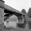
Park Bridge
View from E showing NNE front |
8/6/1976 |
Item Level |
|
 |
On-line Digital Images |
SC 501428 |
Papers of Professor John R Hume, economic and industrial historian, Glasgow, Scotland |
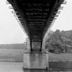
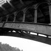
Park Bridge
View looking WNW showing underside |
8/6/1976 |
Item Level |
|
 |
On-line Digital Images |
SC 501429 |
Papers of Professor John R Hume, economic and industrial historian, Glasgow, Scotland |
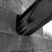
Park Bridge
View from N showing cast-iron arch rib going into masonry pier |
8/6/1976 |
Item Level |
|
 |
On-line Digital Images |
SC 501431 |
Papers of Professor John R Hume, economic and industrial historian, Glasgow, Scotland |
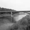
Park Bridge
View from S showing SSW front |
8/6/1976 |
Item Level |
|
 |
On-line Digital Images |
SC 501432 |
Papers of Professor John R Hume, economic and industrial historian, Glasgow, Scotland |
Park Bridge
View from S showing name plate |
8/6/1976 |
Item Level |
|
 |
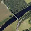
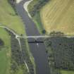
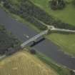
On-line Digital Images |
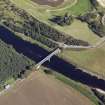
DP 020755 |
RCAHMS Aerial Photography Digital |
Oblique aerial view centred on the road bridge and tollhouse with the remains of the tower adjacent, taken from the W. |
8/9/2006 |
Item Level |
|
 |
On-line Digital Images |
DP 020756 |
RCAHMS Aerial Photography Digital |
Oblique aerial view centred on the road bridge and tollhouse with the remains of the tower adjacent, taken from the SW. |
8/9/2006 |
Item Level |
|
 |
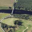
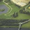
On-line Digital Images |
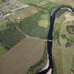
DP 020757 |
RCAHMS Aerial Photography Digital |
General oblique aerial view centred on the road bridge and tollhouse with the remains of the tower adjacent and the village in the distance, taken from the SSW. |
8/9/2006 |
Item Level |
|
 |
On-line Digital Images |
DP 020758 |
RCAHMS Aerial Photography Digital |
Oblique aerial view centred on the road bridge and tollhouse with the remains of the tower adjacent, taken from the SSE. |
8/9/2006 |
Item Level |
|
 |
On-line Digital Images |
DP 020759 |
RCAHMS Aerial Photography Digital |
Oblique aerial view centred on the road bridge and tollhouse with the remains of the tower adjacent, taken from the ESE. |
8/9/2006 |
Item Level |
|
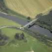 |
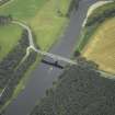
On-line Digital Images |
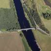
DP 036212 |
RCAHMS Aerial Photography Digital |
Oblique aerial view centred on the bridge with the remains of the tower adjacent, taken from the E. |
11/9/2007 |
Item Level |
|
 |
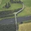
On-line Digital Images |
DP 036213 |
RCAHMS Aerial Photography Digital |
Oblique aerial view centred on the bridge, taken from the NE. |
11/9/2007 |
Item Level |
|
 |
On-line Digital Images |
DP 036214 |
RCAHMS Aerial Photography Digital |
Oblique aerial view centred on the bridge with the remains of the tower adjacent, taken from the NNE. |
11/9/2007 |
Item Level |
|
 |
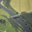
On-line Digital Images |
DP 036215 |
RCAHMS Aerial Photography Digital |
Oblique aerial view centred on the bridge with the remains of the tower adjacent, taken from the N. |
11/9/2007 |
Item Level |
|
 |
On-line Digital Images |
DP 036216 |
RCAHMS Aerial Photography Digital |
Oblique aerial view centred on the bridge with the remains of the tower adjacent, taken from the NW. |
11/9/2007 |
Item Level |
|
 |
On-line Digital Images |
DP 036217 |
RCAHMS Aerial Photography Digital |
Oblique aerial view centred on the bridge with the remains of the tower adjacent, taken from the WNW. |
11/9/2007 |
Item Level |
|
 |
On-line Digital Images |
DP 036218 |
RCAHMS Aerial Photography Digital |
Oblique aerial view centred on the bridge with the remains of the tower adjacent, taken from the SW. |
11/9/2007 |
Item Level |
|
 |
On-line Digital Images |
SC 2412218 |
Records of the Ordnance Survey, Southampton, Hampshire, England |
Park Bridge, NO79NE 41, Ordnance Survey index card, Recto |
c. 1958 |
Item Level |
|


