
Jacksbank


Enclosure(S) (Prehistoric), Field System (Prehistoric)
Site Name Jacksbank
Classification Enclosure(S) (Prehistoric), Field System (Prehistoric)
Canmore ID 36591
Site Number NO78SE 22
NGR NO 7693 8267
NGR Description Centred at NO 7693 8267
Datum OSGB36 - NGR
Permalink http://canmore.org.uk/site/36591


- Council Aberdeenshire
- Parish Glenbervie
- Former Region Grampian
- Former District Kincardine And Deeside
- Former County Kincardineshire
Classified by GRC/AAS as field system. Air photographs: AAS/94/05/G10/25-7 and AAS/94/05/G11/5-8.
NMRS, MS/712/21.
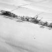
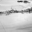
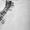
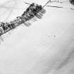
(Location cited as NO 7690 8260: nominated as Site of Regional Significance). Air photography and field survey have recorded a field-system and stone clearance-heaps on the summit of a hill at an altitude of 220m OD.
[Air photographic imagery listed].
NMRS, MS/712/35.
Field Visit (March 1982)
Jacksbank NO 769 826 NO78SE
On the S slope of the broad ridge 600m SSE of Jacksbank farmhouse there are the remains of a field-system and numerous small cairns. The roughly rectilinear fields, which are bounded by stony banks 2m thick and up to 0.4m high, measure at least 60m by 30m, but only one is complete (measuring 32m by 27m). The cairns (at least twenty-five) are up to 5m in diameter by 0.4m in height. In the adjacent field to the E there is a stretch of bank flanking the W fence-line, which may form part of the same field-system.
RCAHMS 1982, visited March 1982

