Accessibility

Font Size

100% 150% 200%

Background Colour

Default Contrast
Close Reset

Myreside, Auchenblae

Enclosure (Period Unknown)(Possible)

Site Name Myreside, Auchenblae

Classification Enclosure (Period Unknown)(Possible)

Canmore ID 36452

Site Number NO77NW 26

NGR NO 7351 7948

Datum OSGB36 - NGR

Permalink http://canmore.org.uk/site/36452

Ordnance Survey licence number AC0000807262. All rights reserved.
Canmore Disclaimer. © Bluesky International Limited 2025. Public Sector Viewing Terms

Toggle Aerial | View on large map

Digital Images

Myreside, Auchenblae, NO77NW 26, Ordnance Survey index card, page number 1, Recto
Myreside, Auchenblae, NO77NW 26, Ordnance Survey index card, page number 1, RectoOblique aerial view centred on the cropmarks of a circular enclosure at Myreside with the farmstead adjacent, looking to the ENE.Oblique aerial view centred on the cropmarks of a circular enclosure at Myreside with the farmstead adjacent, looking to the S.Oblique aerial view centred on the cropmarks of a circular enclosure at Myreside with the farmstead adjacent, looking to the ESE.Oblique aerial view centred on the cropmarks of a circular enclosure at Myreside with the farmstead adjacent, looking to the NNE.Myreside, Auchenblae, NO77NW 26, Ordnance Survey index card, RectoOblique aerial view centred on the cropmarks of a circular enclosure at Myreside with the farmstead adjacent, looking to the ENE.Oblique aerial view centred on the cropmarks of a circular enclosure at Myreside with the farmstead adjacent, looking to the ENE.Oblique aerial view centred on the cropmarks of a circular enclosure at Myreside with the farmstead adjacent, looking to the S.Oblique aerial view centred on the cropmarks of a circular enclosure at Myreside with the farmstead adjacent, looking to the SSE.

Administrative Areas

  • Council Aberdeenshire
  • Parish Fordoun
  • Former Region Grampian
  • Former District Kincardine And Deeside
  • Former County Kincardineshire

Activities

Field Visit (October 1981)

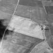
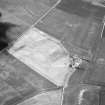
Myreside, Auchenblae + NO 735 794 NO77NW

The cropmark of what may be an oval enclosure, measuring 100m from E to W, is revealed around the N and W sides of a knoll immediately NW of Myreside farmhouse. Nothing is visible on the ground.

RCAHMS 1982, visible October 1981

References

MyCanmore Image Contributions


Contribute an Image

MyCanmore Text Contributions