
East Cairnbeg


Palisaded Enclosure (Prehistoric)
Site Name East Cairnbeg
Classification Palisaded Enclosure (Prehistoric)
Canmore ID 36451
Site Number NO77NW 25
NGR NO 7109 7672
Datum OSGB36 - NGR
Permalink http://canmore.org.uk/site/36451


- Council Aberdeenshire
- Parish Fordoun
- Former Region Grampian
- Former District Kincardine And Deeside
- Former County Kincardineshire
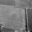
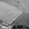
(Location cited as NO 7107 7675). East Cairnbeg. Air photography (AAS/78/8/R7/1-5, AAS/78/8/R10/6-8 and AAS/84/8-10/R20/8-12) has recorded the cropmarks of a double-palisaded oval enclosure in an area of disturbed arable ground at an altitude of 84m OD. It measures about 25m in diameter and the area of disturbed ground measures about 60m in diameter.
There is a possible circular enclosure about 20m to the NW.
NMRS, MS/712/36.
Field Visit (October 1981)
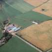
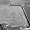
East Cairnbeg NO 710 767 NO77NW
Cropmarks reveal an oval enclosure 180m E of East Cairnbeg farmhouse; it measures about 19m by 13m within double grooves. Nothing is visible on the ground
RCAHMS 1982, visited October 1981

