Accessibility

Font Size

100% 150% 200%

Background Colour

Default Contrast
Close Reset

Fisherhills

Palisaded Enclosure (Prehistoric)

Site Name Fisherhills

Classification Palisaded Enclosure (Prehistoric)

Alternative Name(s) Little Kinnaber; River North Esk

Canmore ID 36342

Site Number NO76SW 10

NGR NO 7258 6210

Datum OSGB36 - NGR

Permalink http://canmore.org.uk/site/36342

Ordnance Survey licence number AC0000807262. All rights reserved.
Canmore Disclaimer. © Bluesky International Limited 2025. Public Sector Viewing Terms

Toggle Aerial | View on large map

Digital Images

Oblique aerial view centred on the cropmarks of the palisaded enclosure, square and round barrows at Fisherhills, looking to the NNE.
Oblique aerial view centred on the cropmarks of the palisaded enclosure, square and round barrows at Fisherhills, looking to the NNE.Oblique aerial view centred on the cropmarks of the palisaded enclosure, square and round barrows at Fisherhills with the North Water viaduct adjacent, looking to the NNE.Oblique aerial view centred on the cropmarks of the palisaded enclosure, square and round barrows at Fisherhills with the North Water viaduct adjacent, looking to the NNW.Oblique aerial view centred on the cropmarks of the palisaded enclosure, square and round barrows at Fisherhills, looking to the WNW.Fisherhills, NO76SW 10, Ordnance Survey index card, RectoOblique aerial view of the cropmarks of the palisaded enclosure with the House of Kinnaber and policies adjacent, taken from the NE.Oblique aerial view of cropmarks of the palisaded enclosure and the North Water Bridge and Viaduct, taken from the WSW.Oblique aerial view of cropmarks of the palisaded enclosure and the North Water Bridge and Viaduct, taken from the SSE.Aerial view.Oblique aerial view centred on the cropmarks of the palisaded enclosure, square and round barrows at Fisherhills with the North Water viaduct adjacent, looking to the NNW.Oblique aerial view centred on the cropmarks of the palisaded enclosure, square and round barrows at Fisherhills, looking to the WNW.Oblique aerial view of the cropmarks of the palisaded enclosure with the House of Kinnaber and policies adjacent, taken from the W.Oblique aerial view of cropmarks of the palisaded enclosure and the North Water Bridge and Viaduct, taken from the S.Oblique aerial view centred on the cropmarks of the palisaded enclosure, square and round barrows at Fisherhills with the North Water viaduct adjacent, looking to the NNE.Oblique aerial view centred on the cropmarks of the palisaded enclosure, square and round barrows at Fisherhills with the North Water viaduct adjacent, looking to the WNW.Oblique aerial view of cropmarks of the palisaded enclosure and the North Water Bridge and Viaduct, taken from the SW.Oblique aerial view centred on the cropmarks of the palisaded enclosure, square and round barrows at Fisherhills with the North Water viaduct adjacent, looking to the NNE.Oblique aerial view centred on the cropmarks of the palisaded enclosure, square and round barrows at Fisherhills, looking to the W.Oblique aerial view centred on the cropmarks of the palisaded enclosure, square and round barrows at Fisherhills, looking to the NNW.Fisherhills, NO76SW 10, Ordnance Survey index card, page number 1, RectoOblique aerial view centred on the cropmarks of the palisaded enclosure at Fisherhills with the North Water viaduct adjacent, looking to the WNW.Oblique aerial view centred on the cropmarks of the palisaded enclosure, square and round barrows at Fisherhills with the North Water viaduct adjacent, looking to the NNW.

Administrative Areas

  • Council Angus
  • Parish Montrose
  • Former Region Tayside
  • Former District Angus
  • Former County Angus

Activities

Field Visit (April 1978)

Fisherhills NO 725 620 NO76SW

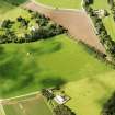
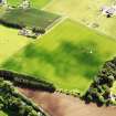
The crop-marks of a large circular enclosure have been recorded W of Little Kinnaber, at the top of the steep scarp that drops down to the bridges across the River North Esk. Two concentric ditches, which lie about 20m apart, describe the S half of the enclosure, which may measure up to 100m in diameter over all.

RCAHMS 1978, visited April 1978

Note (8 June 2015 - 15 August 2016)

Cropmarks have revealed a large palisaded fortification on the crest of the hill on the S side of the River North Esk overlooking the bridges that carry the railway and the A92 public road north from Montrose. It has been photographed on numerous occasions, but while the SW half of the perimeter is clearly defined in successive photography, and presumably heavily eroded, only the inner of the two concentric circuits is known on the NE. Circular on plan, this measures about 55m in diameter (0.24ha), while the outer, lying a little over 20m outside it is about 100m in maximum diameter (0.78ha). No entrances are visible and no structures are discernible amongst the irregular maculae within the interior.

Information from An Atlas of Hillforts of Great Britain and Ireland – 15 August 2016. Atlas of Hillforts SC3106

References

MyCanmore Image Contributions


Contribute an Image

MyCanmore Text Contributions