
Traprain Law


Reservoir (Period Unknown)(Possible)
Site Name Traprain Law
Classification Reservoir (Period Unknown)(Possible)
Canmore ID 361416
Site Number NT57SE 203
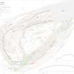
NGR NT 58185 74641
Datum OSGB36 - NGR
Permalink http://canmore.org.uk/site/361416


- Council East Lothian
- Parish Haddington
- Former Region Lothian
- Former District East Lothian
- Former County East Lothian
Field Visit (16 May 2018)
An oval pool of muddy water, possibly originally a small reservoir, stands 25m SE of the triangulation pillar on the summit of Traprain Law. On the date of survey, it measured 11m from NE to SW by 7m transversely. About two thirds of the pool was excavated by J H Cree in 1922 (1923, 221-2), who recovered a small number of artefacts, both prehistoric and of more recent date. The pool was also investigated in 1999 during the Traprain Law Summit Project (HES Archive: MS 726/177, Trench 3), when a similar range of artefacts was discovered.
A wall that follows the NW edge of the pool is recorded under NT57SE 201.
Visited by HES Survey and Recording (GFG, AM) 16 May 2018
(TPR78)
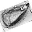
Borehole Survey (24 November 2022)
NT 58174 74633 Two transects were cored: (A) north to south on the short axis of the pond at its widest part and (B) east-west along its long axis. Boreholes were made with a 1.0m long, 3.0cm diameter Eijelkamp peat gouge. Because visibility was limited through water, much stabbing with the gouge was necessary at all boreholes to find narrow gaps between the very many stones/boulders.
Similar sediments are recorded along both transects. The sediment appears to be lacustrine, with Units A and B separated by a consistently observed sharp boundary, although both units are internally unstratified. Unit B is generally less organic than the overlying Unit A. The organic content of the sediments is assumed to be derived from contemporary lacustrine biological activity.
Information from OASIS Id: richardt1-516524 (R Tipping) 2022

