
Traprain Law


Enclosure (Period Unknown), Quarry (Post Medieval)
Site Name Traprain Law
Classification Enclosure (Period Unknown), Quarry (Post Medieval)
Canmore ID 361396
Site Number NT57SE 199
NGR NT 57873 74381
Datum OSGB36 - NGR
Permalink http://canmore.org.uk/site/361396


- Council East Lothian
- Parish Haddington
- Former Region Lothian
- Former District East Lothian
- Former County East Lothian
Field Visit (10 November 2017)
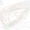
Close to the foot of the SW flank of Traprain Law there is an overgrown length of stone wall that appears to define the S and SW sides of an area, a rhomboid on plan, which is otherwise defined on the N and E by the foot of natural slopes. The wall measures 4m in thickness by 1.5m in height on its downhill side and on the SW it is broken by a (probably) later gap and short length of hollow track. The area defined measures about 36m from E to W by 30m internally and there is no trace of any internal features other than a second track (recorded under NT57SE 198) which runs along the foot of the slope on the N. This is probably of comparatively recent date and may well have led to quarries that are situated on the steeper slopes to the N (TPR56).
The date and function of this wall are unknown, but it is possible that, like a very similar feature on the N side of the hill (at NT 5787 7479), it represents an outwork, or part of an outwork, of the fort, the outer wall of which lies about 60m upslope to the NE (NT57SE 1.00).
Visited by HES Survey and Recording (GFG, AM) 10 November 2017.
(TPR75)

