
Traprain Law


Quarry (Period Unassigned)
Site Name Traprain Law
Classification Quarry (Period Unassigned)
Canmore ID 361395
Site Number NT57NE 278
NGR NT 58549 75013
Datum OSGB36 - NGR
Permalink http://canmore.org.uk/site/361395


- Council East Lothian
- Parish Haddington
- Former Region Lothian
- Former District East Lothian
- Former County East Lothian
Field Visit (13 February 2018)
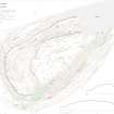
A narrow quarry is situated on the NE flank of Traprain Law, about 30m E of a boundary fence and 45m S of the public road. It measures about 11m from N to S by up to 4m transversely and is at least 2m in depth. It is open to the N where there is a spoil tip measuring at least 8m in diameter.
Visited by HES (GFG, AM) 13 February 2018.
(TRP29)

