
Pricing Change
New pricing for orders of material from this site will come into place shortly. Charges for supply of digital images, digitisation on demand, prints and licensing will be altered.
Upcoming Maintenance
Please be advised that this website will undergo scheduled maintenance on the following dates:
Thursday, 30 January: 11:00 AM - 3:00 PM
During these times, some functionality such as image purchasing may be temporarily unavailable. We apologise for any inconvenience this may cause.
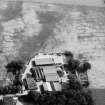
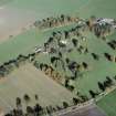
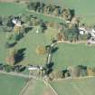
Mains Of Balbegno


Ring Ditch (Prehistoric), Souterrain (Prehistoric)
Site Name Mains Of Balbegno
Classification Ring Ditch (Prehistoric), Souterrain (Prehistoric)
Canmore ID 36136
Site Number NO67SW 6
NGR NO 6420 7320
Datum OSGB36 - NGR
Permalink http://canmore.org.uk/site/36136


- Council Aberdeenshire
- Parish Fettercairn
- Former Region Grampian
- Former District Kincardine And Deeside
- Former County Kincardineshire
NO67SW 6 642 732.
(Location cited as NO 6420 7322: nominated as Site of Regional Significance).
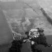
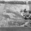
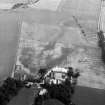
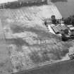
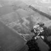
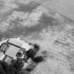
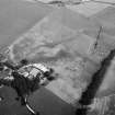
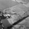
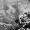
Air photography has recorded the cropmarks on a gentle slope at an altitude of 75m OD. They comprise: a ring-ditch with a Z-shaped cropmark in the entrance, a possible ring-ditch (to the NE), and other cropmarks (one of them an X-mark) in the same field.
[Air photographic imagery listed].
NMRS, MS/712/35.
Field Visit (October 1981)
Mains of Balbegno NO 642 732 NO67SW 6
The cropmark of a penannular enclosure, measuring about 23m in diameter within its ditch, is revealed 80m NE of Mains of Balbegno farmsteading.
RCAHMS 1982, visited October 1981
(DES 1977, 19)

