
Traprain Law


Quarry (Post Medieval), Track (Post Medieval)
Site Name Traprain Law
Classification Quarry (Post Medieval), Track (Post Medieval)
Canmore ID 360893
Site Number NT57SE 193
NGR NT 5782 7447
Datum OSGB36 - NGR
Permalink http://canmore.org.uk/site/360893


- Council East Lothian
- Parish Haddington
- Former Region Lothian
- Former District East Lothian
- Former County East Lothian
Field Visit (13 February 2018)
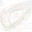
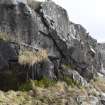
A quarry face extends in discontinuous stretches across the WSW flank of Traprain Law close to its foot. It measures at least 80m from NW to SE and may have been accessed by a length of trackway, measuring some 35m in length and 3m in breadth, that traverses the slope just below it. A drill-hole for explosives at NT 57825 74473 provides evidence that at least some the quarry is probably no earlier than 19th century in date.
Visited by HES (GFG, AM) 13 February 2018.
(TPR21)

